Forest Hill Historic District (Richmond, Virginia)
|
Forest Hill Historic District | |
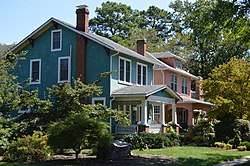 Scene on Springhill Avenue | |
  | |
| Location | Roughly bounded by Riverside Dr., Forest Hill Park, Reedy Cr., Bassett Ave., Southcliff Rd., Cedar Ln.,, Richmond, Virginia |
|---|---|
| Coordinates | 37°31′12″N 77°28′28″W / 37.52000°N 77.47444°WCoordinates: 37°31′12″N 77°28′28″W / 37.52000°N 77.47444°W |
| Area | 140 acres (57 ha) |
| Built | c. 1895 |
| Architect | Frederick Hyland, George Matsumoto, et al. |
| Architectural style | Late 19th And 20th Century Revivals, Late 19th And Early 20th Century American Movements, et al. |
| NRHP reference # | 12000851[1] |
| VLR # | 127-6069 |
| Significant dates | |
| Added to NRHP | October 3, 2012 |
| Designated VLR | June 21, 2012[2] |
The Forest Hill Historic District is a national historic district located at Richmond, Virginia. The district encompasses 1,106 contributing buildings and 5 contributing structures located south of downtown Richmond. The primarily residential area developed starting in the early-20th century as one of the city's early "streetcar suburbs." The buildings are in a variety of popular late-19th and early-20th century architectural styles including frame bungalows, Colonial Revival, Tudor Revival, and Mission Revival. The buildings in Forest Hill exemplify a high quality of materials in their construction. Brick is the dominant building material. Notable non-residential buildings include Forest Hill Presbyterian Church; Good Shepherd Episcopal Church; and Forest Hill Church of Christ.[3]
It was added to the National Register of Historic Places in 2012.[1]
References
- 1 2 "National Register of Historic Places Listings". Weekly List of Actions Taken on Properties. National Park Service. 2012-10-12.
- ↑ "Virginia Landmarks Register". Virginia Department of Historic Resources. Retrieved 19 March 2013.
- ↑ Nancy. W. Kraus (November 2011). "National Register of Historic Places Inventory/Nomination: Forest Hill Historic District" (PDF). Virginia Department of Historic Resources. and Accompanying six photos and Accompanying map

