Farmingdale, New Jersey
| Farmingdale, New Jersey | |
|---|---|
| Borough | |
| Borough of Farmingdale | |
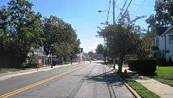 Downtown Farmingdale | |
| Motto(s): Today's Town with Yesterday's Touch | |
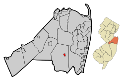 Map of Farmingdale in Monmouth County. Inset: Location of Monmouth County highlighted in the State of New Jersey. | |
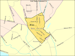 Census Bureau map of Farmingdale, New Jersey | |
| Coordinates: 40°12′05″N 74°10′04″W / 40.201391°N 74.167839°WCoordinates: 40°12′05″N 74°10′04″W / 40.201391°N 74.167839°W[1][2] | |
| Country |
|
| State |
|
| County | Monmouth |
| Incorporated | April 8, 1903 |
| Government[3] | |
| • Type | Borough |
| • Body | Borough Council |
| • Mayor | James A. Daly (R, term ends December 31, 2019; elected to serve an unexpired term)[4][5] |
| • Municipal clerk | Corinne DiCorcia[6] |
| Area[1] | |
| • Total | 0.523 sq mi (1.354 km2) |
| • Land | 0.522 sq mi (1.351 km2) |
| • Water | 0.001 sq mi (0.002 km2) 0.18% |
| Area rank |
547th of 566 in state 48th of 53 in county[1] |
| Elevation[7] | 75 ft (23 m) |
| Population (2010 Census)[8][9][10] | |
| • Total | 1,329 |
| • Estimate (2016)[11] | 1,293 |
| • Rank |
524th of 566 in state 47th of 53 in county[12] |
| • Density | 2,547.7/sq mi (983.7/km2) |
| • Density rank |
243rd of 566 in state 28th of 53 in county[12] |
| Time zone | UTC-5 (Eastern (EST)) |
| • Summer (DST) | UTC-4 (Eastern (EDT)) |
| ZIP code | 07727[13][14] |
| Area code(s) | 732 exchanges: 751, 919, 938[15] |
| FIPS code | 3402522950[1][16][17] |
| GNIS feature ID | 0885218[1][18] |
| Website |
farmingdaleborough |
Farmingdale is a borough in Monmouth County, New Jersey, United States. As of the 2010 United States Census, the borough's population was 1,329,[8][9][10] reflecting a decline of 258 (-16.3%) from the 1,587 counted in the 2000 Census, which had in turn increased by 125 (+8.5%) from the 1,462 counted in the 1990 Census.[19]
Farmingdale was incorporated as a borough by an act of the New Jersey Legislature on April 8, 1903, from portions of Howell Township.[20] The borough is named for its location at the center of an agricultural area.[21]
Geography
According to the United States Census Bureau, the borough had a total area of 0.523 square miles (1.354 km2), including 0.522 square miles (1.351 km2) of land and 0.001 square miles (0.002 km2) of water (0.18%).[1][2]
The borough is completely surrounded by Howell Township,[22] making it part of 21 pairs of "doughnut towns" in the state, where one municipality entirely surrounds another.[23]
Demographics
| Historical population | |||
|---|---|---|---|
| Census | Pop. | %± | |
| 1910 | 416 | — | |
| 1920 | 474 | 13.9% | |
| 1930 | 629 | 32.7% | |
| 1940 | 609 | −3.2% | |
| 1950 | 755 | 24.0% | |
| 1960 | 959 | 27.0% | |
| 1970 | 1,148 | 19.7% | |
| 1980 | 1,348 | 17.4% | |
| 1990 | 1,462 | 8.5% | |
| 2000 | 1,587 | 8.5% | |
| 2010 | 1,329 | −16.3% | |
| Est. 2016 | 1,293 | [11][24] | −2.7% |
| Population sources: 1910-1920[25] 1910[26] 1910-1930[27] 1930-1990[28] 2000[29][30] 2010[8][9][10] | |||
Census 2010
As of the 2010 United States Census, there were 1,329 people, 547 households, and 341.9 families residing in the borough. The population density was 2,547.7 per square mile (983.7/km2). There were 578 housing units at an average density of 1,108.0 per square mile (427.8/km2). The racial makeup of the borough was 89.62% (1,191) White, 2.86% (38) Black or African American, 0.45% (6) Native American, 3.16% (42) Asian, 0.00% (0) Pacific Islander, 1.73% (23) from other races, and 2.18% (29) from two or more races. Hispanic or Latino of any race were 6.92% (92) of the population.[8]
There were 547 households out of which 28.9% had children under the age of 18 living with them, 45.2% were married couples living together, 12.1% had a female householder with no husband present, and 37.5% were non-families. 28.2% of all households were made up of individuals, and 6.8% had someone living alone who was 65 years of age or older. The average household size was 2.43 and the average family size was 3.05.[8]
In the borough, the population was spread out with 21.5% under the age of 18, 8.2% from 18 to 24, 28.3% from 25 to 44, 31.6% from 45 to 64, and 10.4% who were 65 years of age or older. The median age was 39.8 years. For every 100 females there were 103.8 males. For every 100 females ages 18 and older there were 97.9 males.[8]
The Census Bureau's 2006-2010 American Community Survey showed that (in 2010 inflation-adjusted dollars) median household income was $63,191 (with a margin of error of +/- $2,838) and the median family income was $69,688 (+/- $10,093). Males had a median income of $56,518 (+/- $4,270) versus $36,625 (+/- $5,921) for females. The per capita income for the borough was $31,425 (+/- $2,251). About 2.6% of families and 4.0% of the population were below the poverty line, including 5.6% of those under age 18 and 9.6% of those age 65 or over.[31]
Census 2000
As of the 2000 United States Census[16] there were 1,587 people, 625 households, and 406 families residing in the borough. The population density was 2,972.2 people per square mile (1,156.1/km²). There were 638 housing units at an average density of 1,194.9 per square mile (464.8/km²). The racial makeup of the borough was 93.64% White, 1.13% African American, 2.33% Asian, 2.08% from other races, and 0.82% from two or more races. Hispanic or Latino of any race were 3.84% of the population.[29][30]
There were 625 households out of which 37.3% had children under the age of 18 living with them, 51.5% were married couples living together, 8.8% had a female householder with no husband present, and 35.0% were non-families. 29.0% of all households were made up of individuals and 6.6% had someone living alone who was 65 years of age or older. The average household size was 2.54 and the average family size was 3.21.[29][30]
In the borough the population was spread out with 27.0% under the age of 18, 7.4% from 18 to 24, 35.5% from 25 to 44, 21.1% from 45 to 64, and 9.0% who were 65 years of age or older. The median age was 35 years. For every 100 females, there were 102.2 males. For every 100 females age 18 and over, there were 107.0 males.[29][30]
The median income for a household in the borough was $48,889, and the median income for a family was $59,625. Males had a median income of $40,000 versus $27,375 for females. The per capita income for the borough was $21,667. About 5.6% of families and 5.7% of the population were below the poverty line, including 7.0% of those under age 18 and 6.3% of those age 65 or over.[29][30]
Government
Local government
Farmingdale is governed under the Borough form of New Jersey municipal government. The governing body consists of a Mayor and a Borough Council comprising six council members, with all positions elected at-large on a partisan basis as part of the November general election. A Mayor is elected directly by the voters to a four-year term of office. The Borough Council consists of six members elected to serve three-year terms on a staggered basis, with two seats coming up for election each year in a three-year cycle.[3] The Borough form of government used by Farmingdale, the most common system used in the state, is a "weak mayor / strong council" government in which council members act as the legislative body with the mayor presiding at meetings and voting only in the event of a tie. The mayor can veto ordinances subject to an override by a two-thirds majority vote of the council. The mayor makes committee and liaison assignments for council members, and most appointments are made by the mayor with the advice and consent of the council.[32][33]
As of 2018, the mayor of Farmingdale is Republican James A. Daly, whose term of office ends December 31, 2019; Daly had been named as acting mayor following the March 2016 death of John P. "Jay" Morgan.[34] Members of the Borough Council are Council President Michael J. Romano (R, 2019), Erich Brandl (R, 2020), Kaaren Corallo (R, 2018; elected to serve an unexpired term), George Dyevoich (R, 2019), Patricia A. Linszky (R, 2018) and Dr. Don H. Steinfeld (R, 2020).[4][35][36][37][38][39]
The 2012 elections included the election of all six council seats in the wake of the resignation of all six council members during the previous year.[40]
Federal, state and county representation
Farmingdale is located in the 4th Congressional District[41] and is part of New Jersey's 30th state legislative district.[9][42][43]
New Jersey's Fourth Congressional District is represented by Christopher Smith (R).[44] New Jersey is represented in the United States Senate by Democrats Cory Booker (Newark, term ends 2021)[45] and Bob Menendez (Paramus, 2019).[46][47]
For the 2018–2019 session (Senate, General Assembly), the 30th Legislative District of the New Jersey Legislature is represented in the State Senate by Robert Singer (R, Lakewood Township) and in the General Assembly by Sean T. Kean (R, Wall Township) and Ned Thomson (R, Wall Township).[48][49] The Governor of New Jersey is Phil Murphy (D, Middletown Township).[50] The Lieutenant Governor of New Jersey is Sheila Oliver (D, East Orange).[51]
Monmouth County is governed by a Board of Chosen Freeholders consisting of five members who are elected at-large to serve three year terms of office on a staggered basis, with either one or two seats up for election each year as part of the November general election. At an annual reorganization meeting held in the beginning of January, the board selects one of its members to serve as Director and another as Deputy Director.[52] As of 2018, Monmouth County's Freeholders are Freeholder Director Thomas A. Arnone (R, Neptune City, term as freeholder ends December 31, 2019; term as freeholder director ends 2018),[53] Freeholder Deputy Director Lillian G. Burry (R, Colts Neck Township, term as freeholder ends 2020; term as deputy director ends 2018),[54] John P. Curley (R, Middletown Township, 2018),[55] Patrick G. Impreveduto (R, Holmdel Township, 2020)[56] and Dr. Gerry P. Scharfenberger (R, Middletown Township, 2019; appointed to serve an unexpired term).[57][58] Constitutional officers elected on a countywide basis are County clerk Christine Giordano Hanlon (R, 2020; Ocean Township),[59][60] Sheriff Shaun Golden (R, 2019; Howell Township)[61][62] and Surrogate Rosemarie D. Peters (R, 2021; Middletown Township).[63]
Politics
As of March 23, 2011, there were a total of 929 registered voters in Farmingdale, of which 166 (17.9%) were registered as Democrats, 325 (35.0%) were registered as Republicans and 436 (46.9%) were registered as Unaffiliated. There were 2 voters registered to other parties.[64]
In the 2012 presidential election, Republican Mitt Romney received 51.9% of the vote (364 cast), ahead of Democrat Barack Obama with 47.1% (330 votes), and other candidates with 1.0% (7 votes), among the 709 ballots cast by the borough's 966 registered voters (8 ballots were spoiled), for a turnout of 73.4%.[65][66] In the 2008 presidential election, Republican John McCain received 50.1% of the vote (360 cast), ahead of Democrat Barack Obama with 47.1% (338 votes) and other candidates with 1.5% (11 votes), among the 718 ballots cast by the borough's 967 registered voters, for a turnout of 74.3%.[67] In the 2004 presidential election, Republican George W. Bush received 61.0% of the vote (424 ballots cast), outpolling Democrat John Kerry with 38.0% (264 votes) and other candidates with 0.7% (7 votes), among the 695 ballots cast by the borough's 934 registered voters, for a turnout percentage of 74.4.[68]
In the 2013 gubernatorial election, Republican Chris Christie received 75.5% of the vote (379 cast), ahead of Democrat Barbara Buono with 22.1% (111 votes), and other candidates with 2.4% (12 votes), among the 514 ballots cast by the borough's 991 registered voters (12 ballots were spoiled), for a turnout of 51.9%.[69][70] In the 2009 gubernatorial election, Republican Chris Christie received 66.7% of the vote (320 ballots cast), ahead of Democrat Jon Corzine with 24.4% (117 votes), Independent Chris Daggett with 8.1% (39 votes) and other candidates with 0.6% (3 votes), among the 480 ballots cast by the borough's 939 registered voters, yielding a 51.1% turnout.[71]
Education
The Farmingdale School District serves public school students in pre-kindergarten through eighth grade at Farmingdale Elementary School.[72] As of the 2014-15 school year, the district and its one school had an enrollment of 212 students and 19.2 classroom teachers (on an FTE basis), for a student–teacher ratio of 11.0:1.[73]
Public school students in ninth through twelfth grades attend Howell High School, as part of the Freehold Regional High School District.[74] The district also serves students from Colts Neck Township, Englishtown, Freehold Borough, Freehold Township, Howell Township, Manalapan Township and Marlboro.[75] As of the 2014-15 school year, the high school had an enrollment of 2,290 students and 150.0 classroom teachers (on an FTE basis), for a student–teacher ratio of 15.3:1.[76]
Transportation
Roads and highways
As of May 2010, the borough had a total of 6.89 miles (11.09 km) of roadways, of which 5.30 miles (8.53 km) were maintained by the municipality and 1.59 miles (2.56 km) by Monmouth County.[77]
County Route 547 and County Route 524 pass through the borough. In addition, Route 33 and Route 34 pass near the borough, and are concurrent for a mile between the Collingwood Circle and Naval Weapons Station Earle.
Airport
Monmouth Executive Airport is a public-use airport located east of Farmingdale.[78]
Notable people
People who were born in, residents of, or otherwise closely associated with Farmingdale include:
- Arthur Brisbane (1864-1936), the virtual executive director of the estate of William Randolph Hearst's newspaper and media empire. Per TIME magazine he was by 1920 the highest paid newspaper editor in the United States. He built a palatial residence within what is now Allaire State Park that he and his family made their final abode. They would leave his private rail car on a siding in Farmingdale (on the Jersey Central RR), commuting to and from NYC on nearly a daily basis for many years. Upon his death the Will provided for the gifting of over 1,200 acres, including the family home, which would form the heart of Allaire State Park and include the Historic Village at Allaire: "to be a known as Allaire State Park and given as memorial by Arthur Brisbane."
- George Fischbeck (1922-2015), television weatherman.[79]
- Jim Gary (1939–2006), sculptor popularly known for his large, colorful creations of dinosaurs made from discarded automobile parts.[80]
- Shaun Golden (born c. 1967), Monmouth County Sheriff.[81]
- Chris Hill (born 1994), soccer defender who currently plays for Harrisburg City Islanders in the USL.[82]
- Denny Walling (born 1954), Major League Baseball player in the 1980s who played predominantly for the Houston Astros.[83]
References
- 1 2 3 4 5 6 2010 Census Gazetteer Files: New Jersey County Subdivisions, United States Census Bureau. Accessed May 21, 2015.
- 1 2 US Gazetteer files: 2010, 2000, and 1990, United States Census Bureau. Accessed September 4, 2014.
- 1 2 2012 New Jersey Legislative District Data Book, Rutgers University Edward J. Bloustein School of Planning and Public Policy, March 2013, p. 135.
- 1 2 Governing Body, Borough of Farmingdale. Accessed January 28, 2018.
- ↑ 2017 New Jersey Mayors Directory, New Jersey Department of Community Affairs. Accessed May 30, 2017. As of date accessed, Daly was listed as mayor with a term-end year of 2020.
- ↑ Administration, Borough of Farmingdale. Accessed January 28, 2018.
- ↑ U.S. Geological Survey Geographic Names Information System: Borough of Farmingdale, Geographic Names Information System. Accessed March 5, 2013.
- 1 2 3 4 5 6 DP-1 - Profile of General Population and Housing Characteristics: 2010 for Farmingdale borough, Monmouth County, New Jersey, United States Census Bureau. Accessed July 29, 2012.
- 1 2 3 4 Municipalities Grouped by 2011-2020 Legislative Districts, New Jersey Department of State, p. 13. Accessed January 6, 2013.
- 1 2 3 Profile of General Demographic Characteristics: 2010 for Farmingdale borough, New Jersey Department of Labor and Workforce Development. Accessed July 29, 2012.
- 1 2 PEPANNRES - Annual Estimates of the Resident Population: April 1, 2010 to July 1, 2016 - 2016 Population Estimates for New Jersey municipalities, United States Census Bureau. Accessed June 16, 2017.
- 1 2 GCT-PH1 Population, Housing Units, Area, and Density: 2010 - State -- County Subdivision from the 2010 Census Summary File 1 for New Jersey, United States Census Bureau. Accessed December 3, 2012.
- ↑ Look Up a ZIP Code for Farmingdale, NJ, United States Postal Service. Accessed July 29, 2012.
- ↑ Zip Codes, State of New Jersey. Accessed August 28, 2013.
- ↑ Area Code Lookup - NPA NXX for Farmingdale, NJ, Area-Codes.com. Accessed October 12, 2013.
- 1 2 American FactFinder, United States Census Bureau. Accessed September 4, 2014.
- ↑ A Cure for the Common Codes: New Jersey, Missouri Census Data Center. Accessed July 29, 2012.
- ↑ US Board on Geographic Names, United States Geological Survey. Accessed September 4, 2014.
- ↑ Table 7. Population for the Counties and Municipalities in New Jersey: 1990, 2000 and 2010, New Jersey Department of Labor and Workforce Development, February 2011. Accessed July 29, 2012.
- ↑ Snyder, John P. The Story of New Jersey's Civil Boundaries: 1606-1968, Bureau of Geology and Topography; Trenton, New Jersey; 1969. p. 179. Accessed October 25, 2012.
- ↑ Hutchinson, Viola L. The Origin of New Jersey Place Names, New Jersey Public Library Commission, May 1945. Accessed August 30, 2015.
- ↑ Areas touching Farmingdale, MapIt. Accessed July 13, 2015.
- ↑ DeMarco, Megan. "Voters to decide whether to merge two Princetons into one", The Star-Ledger, November 3, 2011. Accessed January 8, 2017. "There are 22 sets of 'doughnut towns' in New Jersey, those where one town wraps around the other town". Note that following voter approval of the Princeton merger, 21 pairs of "doughnut towns" remain.
- ↑ Census Estimates for New Jersey April 1, 2010 to July 1, 2016, United States Census Bureau. Accessed June 16, 2017.
- ↑ Compendium of censuses 1726-1905: together with the tabulated returns of 1905, New Jersey Department of State, 1906. Accessed October 12, 2013.
- ↑ Thirteenth Census of the United States, 1910: Population by Counties and Minor Civil Divisions, 1910, 1900, 1890, United States Census Bureau, p. 337. Accessed August 5, 2012.
- ↑ Fifteenth Census of the United States : 1930 - Population Volume I, United States Census Bureau, p. 717. Accessed July 30, 2012.
- ↑ New Jersey Resident Population by Municipality: 1930 - 1990, Workforce New Jersey Public Information Network. Accessed June 28, 2015.
- 1 2 3 4 5 Census 2000 Profiles of Demographic / Social / Economic / Housing Characteristics for Farmingdale borough, New Jersey, United States Census Bureau. Accessed July 29, 2012.
- 1 2 3 4 5 DP-1: Profile of General Demographic Characteristics: 2000 - Census 2000 Summary File 1 (SF 1) 100-Percent Data for Farmingdale borough, Monmouth County, New Jersey, United States Census Bureau. Accessed July 29, 2012.
- ↑ DP03: Selected Economic Characteristics from the 2006-2010 American Community Survey 5-Year Estimates for Farmingdale borough, Monmouth County, New Jersey, United States Census Bureau. Accessed June 21, 2012.
- ↑ Cerra, Michael F. "Forms of Government: Everything You've Always Wanted to Know, But Were Afraid to Ask", New Jersey State League of Municipalities. Accessed November 30, 2014.
- ↑ "Forms of Municipal Government in New Jersey", p. 6. Rutgers University Center for Government Studies. Accessed June 3, 2015.
- ↑ Ortiz, Jennifer. "Mayor was dedicated to borough", Tri-Town News, March 31, 2016. Accessed July 14, 2016. "Mayor John P. 'Jay' Morgan, 53, who became Farmingdale's mayor in 2004, died on March 27 after a battle with cancer. Morgan had served as an elected official since 1992, when he joined the Borough Council.... Daly has been named as acting mayor, but will retain his seat on council. The remaining years of Morgan's term as mayor are expected to be on the November election ballot."
- ↑ 2017 Municipal User Friendly Budget, Borough of Farmingdale. Accessed July 14, 2016.
- ↑ Monmouth County Directory 2016, Monmouth County, New Jersey. Accessed July 14, 2016.
- ↑ General Election November 7, 2017 Official Results, Monmouth County, New Jersey Clerk, updated November 17, 2017. Accessed January 1, 2018.
- ↑ General Election November 8, 2016 Official Results, Monmouth County, New Jersey Clerk, updated December 8, 2016. Accessed January 30, 2017.
- ↑ November 3, 2015 General Election Official Results, Monmouth County, New Jersey, updated January 27, 2016. Accessed July 14, 2016.
- ↑ Hochron, Adam. "Election Day Brings Close Results to Farmingdale; Official results not finished", HowellPatch, November 7, 2012. Accessed October 12, 2013. "In a year when the entire borough council resigned with the exception of Mayor Jay Morgan, the residents of Farmingdale will have to wait a little while longer to see who will sit at the dais in January with some of the slots separated by only a few votes."
- ↑ Plan Components Report, New Jersey Redistricting Commission, December 23, 2011. Accessed January 6, 2013.
- ↑ 2017 New Jersey Citizen's Guide to Government, p. 57, New Jersey League of Women Voters. Accessed May 30, 2017.
- ↑ Districts by Number for 2011-2020, New Jersey Legislature. Accessed January 6, 2013.
- ↑ Directory of Representatives: New Jersey, United States House of Representatives. Accessed January 5, 2012.
- ↑ About Cory Booker, United States Senate. Accessed January 26, 2015. "He now owns a home and lives in Newark's Central Ward community."
- ↑ Biography of Bob Menendez, United States Senate, January 26, 2015. "He currently lives in Paramus and has two children, Alicia and Robert."
- ↑ Senators of the 114th Congress from New Jersey. United States Senate. Accessed January 26, 2015. "Booker, Cory A. - (D - NJ) Class II; Menendez, Robert - (D - NJ) Class I"
- ↑ Legislative Roster 2018-2019 Session, New Jersey Legislature. Accessed January 22, 2018.
- ↑ District 30 Legislators, New Jersey Legislature. Accessed January 22, 2018.
- ↑ Governor Phil Murphy, State of New Jersey. Accessed January 16, 2018.
- ↑ Lieutenant Governor Oliver, State of New Jersey. Accessed January 16, 2018. "Assemblywoman Oliver has resided in the City of East Orange for over 40 years."
- ↑ Monmouth County Government, Monmouth County, New Jersey. Accessed February 18, 2018.
- ↑ Freeholder Thomas A. Arnone, Monmouth County, New Jersey. Accessed February 18, 2018.
- ↑ Freeholder Lillian G. Burry, Monmouth County, New Jersey. Accessed February 18, 2018.
- ↑ Freeholder John P. Curley, Monmouth County, New Jersey. Accessed February 18, 2018.
- ↑ Freeholder Patrick Impreveduto, Monmouth County, New Jersey. Accessed February 18, 2018.
- ↑ Freeholder Gerry P. Scharfenberger, Ph.D., Monmouth County, New Jersey. Accessed February 18, 2018.
- ↑ Freeholder Gary J. Rich Sr., Monmouth County, New Jersey. Accessed February 4, 2014.
- ↑ The Monmouth County Clerk, Monmouth County, New Jersey. Accessed February 18, 2018.
- ↑ Members List: Clerks, Constitutional Officers Association of New Jersey. Accessed February 18, 2018.
- ↑ About Sheriff Shaun Golden, Monmouth County Sheriff's Office. Accessed February 18, 2018.
- ↑ Members List: Sheriffs, Constitutional Officers Association of New Jersey. Accessed February 18, 2018.
- ↑ Monmouth County Surrogate, Monmouth County, New Jersey. Accessed February 18, 2018.
- ↑ Voter Registration Summary - Monmouth, New Jersey Department of State Division of Elections, March 23, 2011. Accessed December 3, 2012.
- ↑ "Presidential General Election Results - November 6, 2012 - Monmouth County" (PDF). New Jersey Department of Elections. March 15, 2013. Retrieved December 24, 2014.
- ↑ "Number of Registered Voters and Ballots Cast - November 6, 2012 - General Election Results - Monmouth County" (PDF). New Jersey Department of Elections. March 15, 2013. Retrieved December 24, 2014.
- ↑ 2008 Presidential General Election Results: Monmouth County, New Jersey Department of State Division of Elections, December 23, 2008. Accessed December 3, 2012.
- ↑ 2004 Presidential Election: Monmouth County, New Jersey Department of State Division of Elections, December 13, 2004. Accessed December 3, 2012.
- ↑ "Governor - Monmouth County" (PDF). New Jersey Department of Elections. January 29, 2014. Retrieved December 24, 2014.
- ↑ "Number of Registered Voters and Ballots Cast - November 5, 2013 - General Election Results - Monmouth County" (PDF). New Jersey Department of Elections. January 29, 2014. Retrieved December 24, 2014.
- ↑ 2009 Governor: Monmouth County, New Jersey Department of State Division of Elections, December 31, 2009. Accessed December 3, 2012.
- ↑ County School List E-G, Monmouth County, New Jersey. Accessed January 30, 2017.
- ↑ District information for Farmingdale Public School District, National Center for Education Statistics. Accessed December 7, 2016.
- ↑ FRHSD Attendance Boundaries; Which High School Will My Child Attend?, Freehold Regional High School District. Accessed February 3, 3017.
- ↑ Freehold Regional High School District 2016 Report Card Narrative, New Jersey Department of Education. Accessed December 9, 2017. "The Freehold Regional High School District, the largest regional high school District in New Jersey, has six high schools with over 11,000 students and over 1,500 employees and spans 200 square miles. District members include the townships of Colts Neck, Freehold, Howell, Manalapan, and Marlboro, and the boroughs of Englishtown, Farmingdale, and Freehold."
- ↑ School data for Howell High School, National Center for Education Statistics. Accessed December 12, 2016.
- ↑ Monmouth County Mileage by Municipality and Jurisdiction, New Jersey Department of Transportation, May 2010. Accessed July 18, 2014.
- ↑ Monmouth Executive, Federal Aviation Administration. Accessed October 12, 2013.
- ↑ Wilcox, Gregory J. "Dr. George Fischbeck, KABC-TV weatherman and Woodland Hills resident, dies at 92", Los Angeles Daily News, March 25, 2015. Accessed October 20, 2015. "Fischbeck was born July 1, 1922, in Wallington, N.J., the eldest of four children. He grew up on a farm in Farmingdale, N.J., and served in the Air Force in World War II and the Korean War."
- ↑ Fox, Margalit. "Jim Gary, Sculptor Inspired by Junk, Dies at 66", The New York Times, January 19, 2006. Accessed November 27, 2007. "He was 66 and lived in Farmingdale, N.J.... James Gary was born in Sebastian, Fla., on March 17, 1939, and grew up in Colts Neck."
- ↑ Biese, Alex. "GOP panel winnows field of sheriff hopefuls to 2", Asbury Park Press, March 18, 2007. Accessed August 10, 2012. "At its meeting Saturday at Republican headquarters in Freehold, the committee selected Shaun E. Golden of Farmingdale and Kimberly Guadagno of Monmouth Beach as the names to be forwarded on to the Republican convention to be held 9 a.m. March 24 at Brookdale Community College."
- ↑ Chris Hill, Villanova Wildcats men's soccer. Accessed June 13, 2016. "Hometown: Farmingdale, N.J.; High School: Howell"
- ↑ Staff. "Signs A's Contract; Clemson Loses Denny Walling", The Index-Journal (Greenwood, South Carolina), September 6, 1975. Accessed August 12, 2016. "A native of Farmingdale, N.J., Walling led the Atlantic Coast Conference in home runs and runs batted in and was ranked nationally in both categories."
External links

- Farmingdale Borough website
- Farmingdale Elementary School
- Farmingdale Elementary School's 2015–16 School Report Card from the New Jersey Department of Education
- School Data for the Farmingdale School District, National Center for Education Statistics
- Howell High School
- Freehold Regional High School District
- Freehold Regional High School District's 2015–16 School Report Card from the New Jersey Department of Education
- School Data for the Freehold Regional High School District, National Center for Education Statistics
