Falling Creek UDC Jefferson Davis Highway Marker
|
Falling Creek UDC Jefferson Davis Highway Marker | |
 | |
  | |
| Location | US 1 at Falling Creek Wayside, near Richmond, Virginia |
|---|---|
| Coordinates | 37°26′21″N 77°26′21″W / 37.43917°N 77.43917°WCoordinates: 37°26′21″N 77°26′21″W / 37.43917°N 77.43917°W |
| Area | less than one acre |
| Built | 1931 |
| MPS | UDC Commemorative Highway Markers along the Jefferson Davis Highway in Virginia |
| NRHP reference # | 12001220[1] |
| VLR # | 127-6150-0003 |
| Significant dates | |
| Added to NRHP | January 23, 2013 |
| Designated VLR | September 30, 2010[2] |
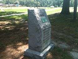
Falling Creek UDC Jefferson Davis Highway Marker is a historic stone highway marker located near Richmond, in Chesterfield County, Virginia. It was erected in 1933, and is one of sixteen erected by the United Daughters of the Confederacy in Virginia along the Jefferson Davis Highway between 1927 and 1946. The marker is a gray granite boulder with rough-cut edges. The stone is engraved with the text “ERECTED BY THE FIRST DISTRICT VIRGINIA DIVISION UNITED DAUGHTERS OF THE CONFEDERACY 1933.” It is located in a wayside established in 1934, that provides access to the Bridge at Falling Creek. It was the first highway wayside park in Virginia.[3]
It was listed on the National Register of Historic Places in 2013.[1]
References
- 1 2 "National Register of Historic Places Listings". Weekly List of Actions Taken on Properties: 1/22/13 through 1/25/13. National Park Service. 2011-06-17.
- ↑ "Virginia Landmarks Register". Virginia Department of Historic Resources. Retrieved 5 June 2013.
- ↑ Ruth D. Snead (May 2010). "National Register of Historic Places Inventory/Nomination: Falling Creek UDC Jefferson Davis Highway Marker" (PDF). Virginia Historic Landmarks Commission.


This article is issued from
Wikipedia.
The text is licensed under Creative Commons - Attribution - Sharealike.
Additional terms may apply for the media files.