Doddabetta
| Doddabetta | |
|---|---|
 Telescope House at the summit of Dodda Betta | |
| Highest point | |
| Elevation | 2,637 m (8,652 ft) [1] |
| Prominence | 2,256 m (7,402 ft) [1] |
| Listing |
Ultra List of Indian states and territories by highest point |
| Coordinates | 11°24′08.7″N 76°44′12.2″E / 11.402417°N 76.736722°ECoordinates: 11°24′08.7″N 76°44′12.2″E / 11.402417°N 76.736722°E [1] |
| Geography | |
 Doddabetta Location of Doddabetta within Tamil Nadu, India | |
| Location | Udagamandalam, Nilgiri District, Tamil Nadu, India |
| Parent range | Nilgiri Hills |
| Climbing | |
| Easiest route | Doddabetta Road |
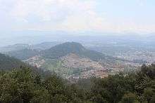
Doddabetta (தொட்டபெட்டா) is the highest mountain in the Nilgiri Mountains at 2,637 metres (8,650 feet). There is a reserved forest area around the peak. It is 9 km from Ooty, on the Ooty-Kotagiri Road in the Nilgiris District of Tamil Nadu, India. It is a popular tourist attraction with road access to the summit. It is the fourth highest peak in South India next to Anamudi, Mannamalai and Meesapulimala. The peaks Hecuba (2375 m), Kattadadu (2418 m) and Kulkudi (2439 m) are the three closely linked summits in the west of the Doddabetta range near to Udagamandalam.
Flora
The area surrounding Doddabetta is mostly forested. Sholas cover the hollows of its slopes. Slightly stunted, rhododendron trees, in the midst of thick coarse grass, flowering sub-alpine shrubs and herbs are common, even very near the peak.[2][3]
Telescope House
There is an observatory at the top of Doddabetta with two telescopes available for the public. It was opened on 18 June 1983 and is run by the Tamil Nadu Tourism Development Corporation (TTDC). The average number of viewers in 2001-2002 was 3500 per day in season and 700 per day in the off season.[4]
References
| Wikimedia Commons has media related to Doddabetta. |
- 1 2 3 "Southern Indian Subcontinent: 4 Mountain Summits with Prominence of 1,500 meters or greater". Peaklist.org. Retrieved 24 November 2011.
- ↑ "Places of Interest:Doddabetta". Archived from the original on 29 September 2007. Retrieved 31 August 2007.
- ↑ "Hills and Peaks". National Informatics Centre, Nilgiris. Retrieved 31 August 2007.
- ↑ "Ooty, Nilgiris". National Informatics Centre, Nilgiris. 20 August 2007. Archived from the original on 2011-01-14.
External links
| State symbols |
|
|---|---|
| Governance |
|
| Topics | |
| Districts |
|
| Major cities | |
Tourism in The Nilgiris | ||
|---|---|---|
Gardens and parks
.jpg) | 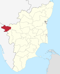 | |
Viewpoint
 | ||
Lake and waterfalls
 | ||
Other tourist spots
 | ||
Events
 | ||