Ooty
| Udagamandalam Ooty | |
|---|---|
| Hill station | |
 | |
| Nickname(s): Queen of Hill Stations | |
 Udagamandalam | |
| Coordinates: 11°25′N 76°42′E / 11.41°N 76.70°ECoordinates: 11°25′N 76°42′E / 11.41°N 76.70°E | |
| Country | India |
| State | Tamil Nadu |
| District | The Nilgiris |
| Government | |
| • Type | Special Grade Municipality |
| • Body | Udagamandalam Municipality |
| Elevation[1] | 2,240 m (7,350 ft) |
| Population (2011)[2] | |
| • Total | 88,430 |
| Languages | |
| • Official | Tamil |
| Time zone | UTC+5:30 (IST) |
| PIN | 643 001 |
| Tele | 91423 |
| Vehicle registration | TN-43 |
| Civic agency ooty homes | Udagamandalam Municipality |
| Climate | Subtropical Highland (Köppen) |
| Precipitation | 1,238 mm (49 in) |
| Avg. annual temperature | 14.4 °C (58 °F) |
| Temperature from Batchmates.com[3] | |
Udagamandalam (also known as Ootacamund (![]()
![]()
Originally occupied by the Toda people, the area came under the rule of the East India Company at the end of the 18th century. The economy is based on tourism and agriculture, along with the manufacture of medicines and photographic film. The town is connected by the Nilgiri ghat roads and Nilgiri Mountain Railway. Its natural environment attracts tourists and it is a popular summer destination.[4] In 2011, the town had a population of 88,430.[2]
Etymology
The origin of the name is obscure. The first known written mention of the place is given as Wotokymund in a letter of March 1821 to the Madras Gazette from an unknown correspondent.[5] In early times it was called OttakalMandu. "Mund" is the Anglicised form of the Toda word for a village, Mandu.[6] The first part of the name is probably a corruption of the local name for the central region of the Nilgiri Plateau.[7]
The stem of the name (Ootaca) comes from the local language in which Otha-Cal literally means "single stone". This is perhaps a reference to a sacred stone revered by the local Toda people. The name probably changed under British rules from Udagamandalam to Ootacamund, and later was shortened to Ooty.[8]
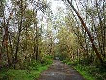
Ooty is in the Nilgiri hills, meaning the "blue mountains", so named due to the Kurunji flower which blooms every twelve years giving the slopes a bluish tinge.[5][9] Because of the mountains and green valleys, Ooty is known as the Queen of Hill Stations.[10]
History
Udagamandalam was originally a tribal land occupied by the Toda and Badagas along with other hill tribes who coexisted through specialisation and trade. The major tribes of Nilgiris area are the Toda, Kota, Irula and Kurumba.The Baduga langague is a dilect of Kannada.
The Toda in the Nilgiris are first referenced in a record belonging to Hoysala king Vishnuvardhana and his general Punisa, dated 1117 CE.[9] The Toda people were known for raising water buffalo. The Badaga people known for farming activities.[10] Nilgiris was ruled by various dynasties like Satavahanas, Gangas, Kadambas, Rashtrakutas, Hoysalas, the Vijayanagara empire and the Rajas of Ummattur (on behalf of Wodeyars of Mysuru).[9][11][12][13][14] Tipu Sultan captured Nilgiris in the eighteenth century and extended the border by constructing a hideout cave-like structure.[10] The Nilgiris came into possession of British East India Company as part of the ceded lands, held by Tipu Sultan, by the treaty of Srirangapatnam in 1799.
In 1818, J. C. Whish and N. W. Kindersley, assistants to John Sullivan, then Collector of Coimbatore, visited Ooty and submitted a report to him. Sullivan camped at Dimbhatti, north of Kotagiri in January 1819 and was enthralled by the beauty of the place. He wrote to Thomas Munro, " ... it resembles Switzerland, more than any country of Europe... the hills beautifully wooded and fine strong spring with running water in every valley."[15] The Toda ceded that part of the town to Sullivan and in May 1819, he began to build his bungalow at Dimbhatti. He also started work on a road from Sirumugai to Dimbhatti that year. The road was completed in May 1823, and extended up to Coonoor by 1830-32.[5]
Ooty served as the summer capital of the Madras Presidency; it was visited by British officials during the colonial days as a popular summer resort.[16] Soldiers were sent to nearby Wellington to recuperate. Wellington is the home of the Madras Regiment of the Indian Army.[17][18] After Independence, it developed into a popular hill resort.
Geography
Climate
Ooty features a subtropical highland climate (Cwb) under Köppen climate classification.[19] Despite its location in the tropics, in contrast with most of South India, Ooty generally features mild conditions throughout the year. However, night time in the months of January and February is typically cold. Generally, the town appears to be eternally stuck in the spring season. Temperatures are relatively consistent throughout the year; with average high temperatures ranging from about 17–20 °C (63–68 °F) and average low temperatures between approximately 5–12 °C (41–54 °F).
The highest temperature ever recorded in Ooty was 25 °C (77 °F), which by South Asian standards is uncharacteristically low for an all-time record high temperature. The rainy season in Ooty is generally cool and windy with high humidity. The wind chill may fall to as low as 5 °C (41 °F) during the day time. Wind is always high throughout the year. The lowest temperature was −2 °C (28 °F).[20] The city sees on average about 125 cm (49 in) of precipitation annually, with a marked drier season from December through March.
| Climate data for Ooty (Udagamandalam) | |||||||||||||
|---|---|---|---|---|---|---|---|---|---|---|---|---|---|
| Month | Jan | Feb | Mar | Apr | May | Jun | Jul | Aug | Sep | Oct | Nov | Dec | Year |
| Average high °C (°F) | 20.3 (68.5) |
20.9 (69.6) |
22.2 (72) |
22.6 (72.7) |
22.0 (71.6) |
18.3 (64.9) |
16.9 (62.4) |
17.4 (63.3) |
18.4 (65.1) |
18.8 (65.8) |
18.7 (65.7) |
19.7 (67.5) |
19.7 (67.4) |
| Daily mean °C (°F) | 12.4 (54.3) |
13.6 (56.5) |
15.2 (59.4) |
16.3 (61.3) |
16.6 (61.9) |
14.8 (58.6) |
14.1 (57.4) |
14.4 (57.9) |
14.4 (57.9) |
14.6 (58.3) |
13.7 (56.7) |
12.9 (55.2) |
14.4 (58) |
| Average low °C (°F) | 5.6 (42.1) |
6.5 (43.7) |
8.8 (47.8) |
10.7 (51.3) |
11.4 (52.5) |
11.2 (52.2) |
11.0 (51.8) |
10.9 (51.6) |
10.4 (50.7) |
10.1 (50.2) |
8.6 (47.5) |
6.7 (44.1) |
9.3 (48.8) |
| Average precipitation mm (inches) | 20.5 (0.807) |
10.2 (0.402) |
25.8 (1.016) |
75.4 (2.969) |
147.5 (5.807) |
136.7 (5.382) |
181.1 (7.13) |
123.7 (4.87) |
134.9 (5.311) |
189.2 (7.449) |
139.9 (5.508) |
52.8 (2.079) |
1,237.7 (48.73) |
| Average rainy days | 1 | 1 | 2 | 5 | 8 | 8 | 10 | 9 | 9 | 11 | 7 | 4 | 75 |
| Mean daily sunshine hours | 8 | 8 | 8 | 8 | 7 | 4 | 4 | 4 | 5 | 5 | 6 | 7 | 6 |
| Source #1: Indian Meteorological Department (1901-2000)[21] | |||||||||||||
| Source #2: Climate-Data.org for mean temperatures, altitude: 2214m,[19] Weather2Travel for sunshine and rainy days[22] | |||||||||||||
Places of interest
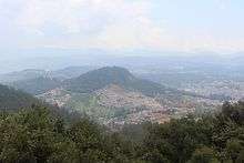
Ooty is situated in the Nilgiri Biosphere Reserve. Many of the forested areas and water bodies are off-limits to most visitors to protect this fragile ecosystem. Some areas of the Biosphere Reserve have been earmarked for tourism development, and steps are being undertaken to open these areas to visitors whilst conserving the area.[23] It is situated at an altitude of 2,240 metres (7,350 feet) above sea level.[1]
Gardens and parks

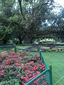
The Government Rose Garden (formerly Centenary Rose Park)[24][25] is the largest rose garden in India.[26] It is situated on the slopes of the Elk Hill in Vijayanagaram of Ooty town.[27] at an altitude of 2200 meters. Today this garden has one of the largest collection of roses in the country with more than 20,000 varieties of roses of 2,800 cultivars.[28] The collection includes hybrid tea roses, Miniature Roses, Polyanthas, Papagena, Floribunda, Ramblers, Yakimour and roses of unusual colours like black and green.

The 22-acre (89,000 m2) Ooty Botanical Gardens was laid out in 1847[29] and is maintained by the Government of Tamil Nadu. The Botanical Garden is lush, green, and well-maintained. A flower show along with an exhibition of rare plant species is held every May. The gardens have around a thousand species, both exotic and indigenous, of plants, shrubs, ferns, trees, herbal and bonsai plants.[30] The garden has a 20-million-year-old fossilised tree.[31][32]
Deer Park is located on the edge of Ooty Lake. It is the highest altitude zoo in India aside from the zoo in Nainital, Uttarakhand. This park was formed to house a number of species of deer and other animals.[33]
Lakes and dams
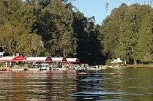
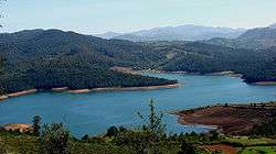
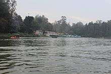
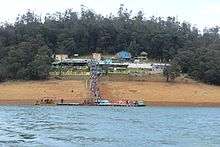
Ooty lake covers an area of 65 acres.[34] The boat house established alongside the lake, which offers boating facilities to tourists, is a major tourist attraction in Ooty. It was constructed in 1824 by John Sullivan, the first collector of Ooty. The lake was formed by damming the mountain streams flowing down Ooty valley.[34] The lake is set among groves of Eucalyptus trees with a railway line running along one bank. During the summer season in May, boat races and boat pageantry are organised for two days at the lake.[35][36]
Pykara is a river located 19 km from Ooty.[37] The Pykara is considered very sacred by the Todas.[38] The Pykara river rises at Mukurthi peak and passes through a hilly tract, generally keeping to the north and turns to the west after reaching the plateau's edge.[38] The river flows through a series of cascades; and the last two falls of 55 meters and 61 meters are known as Pykara falls.[38] The falls are approximately 6 km from the bridge on the main road. A boat house by the Pykara falls and dam is an added attraction to tourists.[37][39] Kamaraj Sagar Dam (also known as Sandynalla reservoir)[40] is located 10 km from the Ooty bus stand.[41][42] It is a picnic spot and a film shoot location on the slopes of the Wenlock Downs.[43] The various tourist activities at the dam include fishing and studying nature and the environment.[44] Parsons Valley Reservoir is the primary water source for the town and is mainly in a reserved forest and thus largely off-limits to visitors. Emerald Lake, Avalanche Lake and Porthimund Lake are other lakes in the region.
Reserve forests

Doddabetta is the highest peak (2,623 m) in the Nilgiris, about 10 km from Ooty. It lies at the junction of the Western and Eastern Ghats surrounded by dense Sholas. The pine forest situated between Ooty and Thalakunda is a small downhill region where pine trees are arranged in an orderly fashion. Wenlock Downs is a grassland area typical of the original bioscape of the Nilgiris with gently undulating hills. Mudumalai National Park and tiger reserve lies on the north western side of the Nilgiri Hills.[45][46] The sanctuary is divided into 5 ranges - Masinagudi, Thepakadu, Mudumalai, Kargudi and Nellakota. Here one can often spot herds of endangered Indian elephants, vulnerable gaur, and chital. The sanctuary is a haven for Bengal tigers[47], Indian leopards and other threatened species.[48] There are at least 266 species of birds in the sanctuary, including critically endangered species like the Indian white-rumped vulture and the long-billed vulture.[49] Mukurthi National Park is a 78.46 km2 protected area located in the south-eastern corner of the Nilgiris Plateau west of Ooty. The park was created to protect its keystone species, the Nilgiri tahr.[50] The Western Ghats, Nilgiri Sub-Cluster (6,000 km2 (2,300 sq mi)), including all of Mudumalai National Park, is under consideration by the UNESCO World Heritage Committee for selection as a World Heritage Site.[51]
Tribal huts and museum
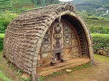
There are a few Toda huts on the hills above the Botanical Garden, where Todas still dwell. There are other Toda settlements in the area, notably Kandal Mund near Old Ooty. Although many Toda have abandoned their traditional distinctive huts for concrete houses,[52] a movement is now afoot to build tradition barrel-vaulted huts, and during the last decade forty new huts have been built and many Toda sacred dairies renovated.[53]
The Tribal Museum is part of the campus of Tribal Research Centre which is in Muthorai Palada (10 km from Ooty town). It is home to rare artefacts and photographs of tribal groups of Tamil Nadu as well as the Andaman and Nicobar Islands, and anthropological and archaeological primitive human culture and heritage. The Tribal Museum also displays houses belonging to Toda, Kota, Paniya, Kurumba and Kanikarans.
Nilgiri Mountain Railway
The Nilgiri Mountain Railway was built by the British in 1908,[54] and was initially operated by the Madras Railway Company. The railway still relies on its fleet of steam locomotives.[55] NMR comes under the jurisdiction of the newly formed Salem Division. In July 2005, UNESCO added the Nilgiri Mountain Railway as an extension to the World Heritage Site of Darjeeling Himalayan Railway, the site then became known as "Mountain Railways of India."[56] after it satisfied the necessary criteria, thus forcing abandonment of the modernisation plans. For the past several years diesel locomotives have taken over from steam on the section between Coonoor and Udagamandalam. Local people and tourists have led a demand for steam locos to once again haul this section.[55]
Historical buildings

Stone House is the first bungalow constructed in Ooty. It was built by John Sullivan and was called Kal Bangala by the tribals (Kal means stone in local tribal language). John Sullivan started building Stone House in 1822, acquiring land from the Todas at one rupee an acre.[15] Today, it is the official residence for the principal of the Government Arts College, Ooty[57][58]
St Stephen's Church is located on the road to Mysore in Ooty,[59] in the state of Tamil Nadu, India. It is one of the oldest churches in the Nilgiris district.[60][61] The church dates back to the 19th century. Stephen Rumbold Lushington, the then governor of Madras, who keenly felt the need for a cathedral in Ooty which was exclusively for the British, laid the foundation stone for the church on 23 April 1829, to coincide with the birthday of King George IV. St Stephen's Church was consecrated by John Matthias Turner, Bishop of Calcutta, on 5 November 1830. It was thrown open to public communion on Easter Sunday 3 April 1831. It came under the Church of South India in 1947.[35] The architect in charge was John James Underwood, Captain, Madras Regiment.[62]
In 1882, the rules and game of snooker were first drafted and codified in the "Ooty Club". The club still houses the billiards table that was used.
Demographics
According to the 2011 census, Udagamandalam had a population of 88,430 with a sex-ratio of 1,053 females for every 1,000 males, much above the national average of 929.[2][63] A total of 7,781 were under the age of six, constituting 3,915 males and 3,866 females. Scheduled Castes and Scheduled Tribes accounted for 28.98% and 0.3% of the population respectively. The average literacy of the city in 2011 was 90.2%,[64] compared to the national average of 72.99%.[63] The city had a total of 23,235 households. There were a total of 35,981 workers, comprising 636 cultivators, 5,194 agricultural labourers, 292 in household industries, 26,411 other workers, 3,448 marginal workers, 65 marginal cultivators, 828 marginal agricultural labourers, 56 marginal workers in household industries and 2,499 other marginal workers.[65] As per the religious census of 2011, Udagamandalam had 64.36% Hindus, 21.25% Christians, 13.37% Muslims, 0.03% Sikhs, 0.3% Buddhists, 0.4% Jains, 0.28% following other religions and 0.02% following no religion or did not indicate any religious preference.[66]
Tamil is the official language of Udagamandalam. Languages native to the Nilgiris including Badaga, Paniya and Kurumba.[67] Due to its proximity to the neighbouring state of Karnataka and being a tourist destination, English, Kannada also spoken and understood to an extent.[68] According to the 2001 census, the most widely spoken languages were Baduga followed Tamil, spoken by 15,477, followed by Kannada with 15,404 speakers.[69]
Administration and politics
Ooty is the district headquarters of the Nilgiris district.[70] The Ootacamund assembly constituency is part of the Nilgiris Lok Sabha constituency.[71]
Culture
Recreation
Snooker originated on the billiard tables of the Ootacamund Club, invented by an army officer Neville Francis Fitzgerald Chamberlain.[72] There was also a cricket ground with regular matches played between teams from the Army, the Indian Civil Service and the business sector. Visiting teams would come from various parts of India as well as from the island of Ceylon.
There were riding stables and kennels at Ooty and the Ootacamund Hounds hunted across the surrounding countryside and the open grasslands of the Wenlock Downs, named after Beilby Lawley, 3rd Baron Wenlock. Horse races are held at Ooty Racecourse.[73][74][75][76][77][78][79]
Karan Johar's Kuch Kuch Hota Hai was filmed in Ooty. The diverse landscape of Ooty offers an opportunity to explore a number of adventure sports and recreational activities, including hang gliding. Located around 20 km from Ooty, Kalhatty in the mountain ranges of Nilgiris is a site for hang gliding. Kalhatty has a launch area that can be reached by jeep. Ooty Golf Course is located in Ooty town.[80][81] The golf course is at an altitude of 7600 feet.[82] It is owned by the Gymkhana club in Ooty. The course extends over 193.56 acres[83] and comprises 18 holes.[82] The England cricket captain Colin Cowdrey was born in Ooty.[84]
Economy and infrastructure
Contrary to the thought that much of the local economy is now dominated by tourism, Ooty is still a supply base and market town for the surrounding area which is still largely dependent on agriculture, including the cultivation of "English vegetables" and "English fruits" grown locally. This primarily consists of potato, carrot, cabbage and cauliflower and the fruits being peaches, plums, pears and strawberries.[85] There is a daily wholesale auction of these products at the Ooty Municipal Market. Dairy farming has long been present in the area and there is a cooperative dairy manufacturing cheese and skimmed milk powder. As a result of the local agricultural industry, certain research institutes are based in Ooty. These include a soil conservation centre, livestock farm and a potato research farm. Efforts are being made to diversify the range of local crops with Floriculture and Sericulture being introduced in the local area, as well as the cultivation of mushrooms.[85]
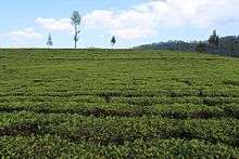
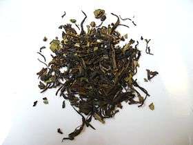
Hindustan Photo Films manufactures photo films in Ooty.[86] Human Biologicals Institute, which manufactures human rabies vaccine is present in Ooty near Pudumand. Other manufacturing industries are located in the outskirts of Ooty. The most significant of these are in Ketti (manufacture of needles); Aruvankadu (manufacture of cordite) and Coonoor (manufacture of rabies vaccine). Cottage industries in the area including chocolate, pickle manufacture and carpentry. Home-made chocolates are popular among the tourists and the locals. The local area is known for tea cultivation and is economically grown in Ooty, Coonoor, Kotagiri and across Nilgiris district. The elevation is about 1,800 m (6,000 ft) above the sea level. Soil conditions, elevation and climatic conditions give flavour to the tea grown here.
Transport
Road
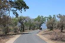
Ooty is well connected to the road network. It is 306 km from Bengaluru (via Mysore and Bandipur), 558 km (347 mi) from Chennai[87] (via Salem, Erode, and Coimbatore), 86 km (53 mi) from Coimbatore and 158 km (98 mi) from Mysore, 246 km from Kannur, 180 km from Calicut and nearly 100 km from Wayanad.[88] Ooty is situated on NH 181 and is connected by road via the five main accepted Nilgiri Ghat Roads. Bus services operated by TNSTC, KSRTC (Karnataka) and KSRTC (Kerala) connect major towns in the state, nearby towns in the district such as Coonoor about 21 km, Kotagiri about 31 km, and Gudalur about 50 km and nearby cities to Mysore, Kannur, Wayanad and Calicut.
Rail
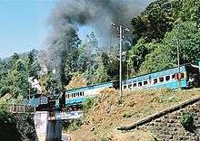
Udhagamandalam railway station is connected with Mettupalayam by NMR metre gauge service.[89] In 1882, a Swiss engineer named Arthur Riggenbach came to the Nilgiri Hills on an invitation from Government of India and he submitted an estimate for a line costing GB£132,000. The Nilgiri Railway Company was formed in 1885 and planning work commenced in 1886. The work on the line commenced in August 1891 and the Mettupalayam-Coonoor section of the track was opened for traffic on 15 June 1899. In January 1903, the Indian Government purchased the line, and took over the construction of the extension from Coonoor to Ooty.
The Nilgiri Mountain Railway was operated by the Madras Railway until 31 December 1907 on the behalf of the Government. In January 1908, the railway line was handed over to South Indian Railway. The line from Coonoor to Ooty was completed in 1908. On 15 October, Arthur Lawley, Governor of Madras opened the new railway to traffic.[90] The Nilgiri Mountain Railway (NMR) is one of the oldest mountain railways in India and was declared by the UNESCO as a World Heritage Site in July 2005. It is the only rack railway in India, and uses the Abt system. [91][92]
Air
The nearest airport is Coimbatore, around 96 km (60 mi) away and Bengaluru Kempegowda International Airport is 273 km away. Ooty has three helipads, one at Theettukal and two at Kodanad. The Theettukal helipad was approved by Airports Authority of India for defence and VIP services. Pawan Hans was supposed to start its service with Bell 407, but being surrounded by farmland, disruption of the farm animals there has put the operations on hold for commercial activities.[93][94][95][96]
Education
Boarding schools have been a feature of Ooty since the days of the British Raj. They offer a significant contribution to the local economy. The facilities and standards of education are considered amongst the highest in India,[97] and so these schools are popular amongst the elite of India and some of the neighbouring countries.
See also
References
- 1 2 "About Municipality". municipality.tn.gov.in. Archived from the original on 15 January 2008. Retrieved 15 February 2008.
- 1 2 3 "Udhagamandalam City Population Census 2011 - Tamil Nadu". Census Population.
- ↑ "Ooty: In the Lap of the Nilgiris". batchmates.com. Archived from the original on 24 February 2011. Retrieved 15 February 2008.
- ↑ "Ooty in Tamilnadu". Tamilnadu.com. 14 December 2012.
- 1 2 3 "History". ooty.net. Retrieved 15 February 2008.
- ↑ Mathew Chacko, Pariyaram (2005). Tribal Communities and Social Change. SAGE Publications India, 2005. pp. 180, 188. ISBN 978-0761-933-30-4.
- ↑ Price, Sir Frederick (1908). Ootacamund, A History. Madras Govt. Press. pp. 14–15.
- ↑ "Ooty History". ooty.ind.in. Retrieved 15 February 2008.
- 1 2 3 Francis, Walter (1908). Madras District Gazetteers: The Nilgiris. 1. New Delhi: Asian Educational Services. pp. 90–94, 102–105. ISBN 978-81-2060-546-6.
- 1 2 3 "Ooty History". evoire.com. Archived from the original on 24 September 2010. Retrieved 15 February 2008.
- ↑ Senapati, Nilamani; Sahu, N. K. (1955). Gazetteers of India: Nilgiris District. Government Press. pp. 3, 199–201, 866.
The location of the Nilgiris is unique that it was in the tri-junction of ancient Tamil kingdoms of Cholas, Cheras and the Pandyas. Hence, it was under Cheras, Cholas or local chieftains at various...
- ↑ Sundaresan, C.S. (1 January 2007). South Asia and Multilateral Trade Regime: Disorders for Development. Regal Publications. p. 81. ISBN 978-8189-915-31-5.
- ↑ Indian Navy (1989). Maritime Heritage of India. Notion Press. p. 244. ISBN 978-9352-069-17-0.
At their peak, the Cholas ruled over not just the whole of south India, but also conquered island nations..
- ↑ Sagar, Ravi. "Decoding the Nilgiris" (PDF). India Brand Equity Foundation: 53.
Not even the dynastic rulers—the Cheras, the Cholas, the Pandiyas, the Rashtrakutas, the Gangas, the Pallavas, the Kadambas and the Hoysalas—can be credited with discovering this jewel (Nilgiris) in their crown.
- 1 2 "One Man's Ooty", The Hindu, India, 16 January 2005
- ↑ The Illustrated Weekly of India. Published for the proprietors, Bennett, Coleman & Company, Limited, at the Times of India Press. 1975.
- ↑ History of Ootacamund by Sir Frederick Price, Madras Government Press, 1908.
- ↑ Sir Arthur Lawley, Eloquent Knight Errant, D. J. Hogg. Chapter 5: "Ruler of the Raj, Ooty, Lady Lawley Cottage" (Western Australian Red Cross), 2008 iBooks
- 1 2 "Climate: Ooty - Climate graph, Temperature graph, Climate table". Climate-Data.org. Archived from the original on 27 February 2014. Retrieved 30 September 2015.
- ↑ "Ooty in Tamil Nadu". Archived from the original on 5 March 2016.
- ↑ "Monthly mean maximum & minimum temperature and total rainfall based upon 1901-2000 data" (PDF). imd.gov.in. Archived from the original (PDF) on 13 April 2015. Retrieved 30 September 2015.
- ↑ "Ooty Climate and Weather Averages, India.htm". Weather2Travel. Retrieved 30 September 2015.
- ↑ "Ban on carry bags". The Hindu. Chennai, India. 4 February 2005.
- ↑ "Rose Park to be renamed", The Hindu, India, 23 May 2009
- ↑ "A rose garden by another name causes confusion", The Hindu, India, 17 May 2008
- ↑ "Tourism - Ooty". Archived from the original on 2 January 2010. Retrieved 22 January 2011.
- ↑ "Rose Garden". Archived from the original on 2 November 2014. Retrieved 22 January 2011.
- ↑ "World Federation of Rose Societies". Retrieved 21 January 2011.
- ↑ D, Radhakrishnan (9 June 2009), "A tribute to creator of Ooty Botanical Garden", The Hindu, India
- ↑ "Ooty to host spices show for first time". The Hindu. India. 11 March 2010.
- ↑ "Hills beckon again". Tribuneindia.com. Retrieved 22 January 2011.
- ↑ "Tamil Nadu - Government Botanical Garden". Scstsenvis.nic.in. Archived from the original on 2 January 2010. Retrieved 22 January 2011.
- ↑ "Ooty Deer Park". eOoty.com.
- 1 2 "Ooty lake". Nilgiris.tn.gov.in. Archived from the original on 14 January 2011. Retrieved 1 February 2011.
- 1 2 "Ooty - Lake". Ooty.com. Retrieved 1 February 2011.
- ↑ "Summer festival in Ooty". The Hindu. 27 March 2010.
- 1 2 "Ooty - Pykara Falls". ooty.com. Retrieved 19 August 2011.
- 1 2 3 "Pykara". Archived from the original on 21 July 2011. Retrieved 19 August 2011.
- ↑ T, Ramakrishnan. "Pykara power station a trendsetter". The Hindu. Archived from the original on 15 December 2008. Retrieved 19 August 2011.
- ↑ "The Romance of the Nilgiri Trout:Coarse Fishing". Nwea.in. Archived from the original on 21 July 2011. Retrieved 3 February 2011.
- ↑ "Kamaraj Sagar Dam and Pykara Lake being polluted". The Hindu. 6 November 2008.
- ↑ "Nilgiris tourist info". Nilgiris.tn.gov.in. Archived from the original on 31 August 2010. Retrieved 3 February 2011.
- ↑ "Kamraj sagar lake". Ooty-tourism.com. Retrieved 3 February 2011.
- ↑ "Kamraj Sagar (Sandynallah Reservoir):". Nilgiris.tn.gov.in. Archived from the original on 14 January 2011. Retrieved 3 February 2011.
- ↑ "India Based Neutrino Observatory & conserving the largest wild populations of the Asian elephant". Letter to Chief Minister of Tamil Nadu. rainforestinfo.org. Retrieved 3 November 2009.
- ↑ Dogra, IFS, Rakesh Kumar, Wildlife Warden, Plan for Mudumalai Wildlife Sanctuary and National Park (2007-08 to 2016-17) Udagamandalam, Tamil Nadu Forest Department, Mount Stuart Hill, Udagamandalam-643 001, Tamil Nadu, India
- ↑ Radha Venkatesan (9 June 2008). "Big leap for big cat: TN has 37 of them today". The Hindu. Retrieved 9 June 2008.
- ↑ "Mudumalai". Wild Biodiversity. TamilNadu Forest Department. Archived from the original on 9 April 2009. Retrieved 30 October 2009.
- ↑ "Mudumalai Wildlife Sanctuary". Conservation database. Bangalore: Ashoka Trust for Research in Ecology and the Environment Eco-Informatics Center. Archived from the original on 24 December 2009. Retrieved 9 November 2009.
- ↑ Dogra, Rakesh Kumar (7 July 2006), Mukurthi National Park Management plan; 2004-2009, The Protected Area part 1.doc (Draft ed.), Udagamandalam, Tamil Nadu: Wildlife Warden, Mount Stuart Hill,
- ↑ UNESCO, World Heritage sites, Tentative lists, Western Ghats sub cluster, Ooty. retrieved 4/20/2007 World Heritage sites, Tentative lists
- ↑ Walker, Anthony R. (2004). "The Truth About The Toda". Frontline, The Hindu. Archived from the original on 13 October 2007.
- ↑ Chhabra, Tarun (2005). "How Traditional Ecological Knowledge addresses Global Climate change: the perspective of the Todas - the indigenous people of the Nilgiri hills of South India" (PDF). Proceedings of the Earth in Transition: First World Conference. Archived from the original (PDF) on 4 September 2012.
- ↑ "Mountain Railways of India". UNESCO. Retrieved 1 March 2010.
- 1 2 Indian Hill Railways: The Nilgiri Mountain Railway (TV). BBC. 21 February 2010. Retrieved 1 March 2010.
- ↑ NMR added as a World Heritage Site
- ↑ Tourist Guide to South India. South India. 2006. p. 96. ISBN 81-7478-175-7.
- ↑ Bradnock, Robert (2000). South India handbook: the travel guide. South India. p. 153. ISBN 1-900949-81-4.
- ↑ "Churches". Retrieved 2 February 2011.
- ↑ "St. Stephen's Church". Retrieved 2 February 2011.
- ↑ "Ooty Tourist Attractions". Retrieved 2 February 2011.
- ↑ "Ootacamund-Heritage Trail" (PDF). Archived from the original (PDF) on 24 July 2011. Retrieved 2 February 2011.
- 1 2 "Census Info 2011 Final population totals". Office of The Registrar General and Census Commissioner, Ministry of Home Affairs, Government of India. 2013. Retrieved 26 January 2014.
- ↑ "Provisional Population Totals, Census of India 2011" (PDF). Retrieved 27 February 2016.
- ↑ "Census Info 2011 Final population totals - Uthagamandalam". Office of The Registrar General and Census Commissioner, Ministry of Home Affairs, Government of India. 2013. Retrieved 26 January 2014.
- ↑ "Population By Religious Community - Tamil Nadu" (XLS). Office of The Registrar General and Census Commissioner, Ministry of Home Affairs, Government of India. 2011. Retrieved 13 September 2015.
- ↑ International School of Dravidian Linguistics (1996). The encyclopaedia of Dravidian tribes. 2. International School of Dravidian Linguistics. p. 170.
- ↑ "Languages in Ooty". mapsofindia.com. Archived from the original on 2 March 2008. Retrieved 16 February 2008.
- ↑ "OFFICIAL CENSUS OF INDIA 2001". Archived from the original on 15 March 2016. Retrieved 19 April 2016.
- ↑ "List of Parliamentary and Assembly Constituencies" (PDF). Election Commission of India. Election Commission of India. Archived from the original (PDF) on 31 October 2008. Retrieved 10 October 2008.
- ↑ "Hill Station in Nilgiri Hills". nilgirihills.in. Archived from the original on 13 May 2011. Retrieved 16 February 2008.
- ↑ Maume, C."Sporting Vernacular 11. Snooker" Archived 25 February 2007 at the Wayback Machine., The Independent, 26 April 1999, (Retrieved 25 February 2007)
- ↑ D. Radhakrishnan (2011-05-04). "Lucky draw to mark Ooty racing milestone". The Hindu. Retrieved 2011-09-14.
- ↑ "Beauty of race course to be enhanced". The Hindu. 2011-04-15. Retrieved 2011-09-22.
- ↑ D. Radhakrishnan (2011-04-14). "Ooty waits for the race to begin". The Hindu. Retrieved 2011-09-22.
- ↑ "Ooty Horse Racing". indiaandindians.com. Retrieved 2011-09-14.
- ↑ "Ooty (Udagamandalam): Racecourse". lonelyplanet.com. Retrieved 2011-09-14.
- ↑ "Ooty Race Course". india9.com. 2005-06-07. Retrieved 2011-09-14.
- ↑ D. Radhakrishnan (2011-04-17). "An important milestone in the Ooty racing season". The Hindu. Retrieved 2011-09-14.
- ↑ "Ooty History". Ooty.com. Retrieved 3 February 2011.
- ↑ Duttagupta, Ishani (19 September 2010), "Young & wealthy executives transforming the face of golfing", The Economic Times, India
- 1 2 "Ooty Golf Club". Indiagolfcourses.com. Archived from the original on 10 December 2010. Retrieved 2011-02-03.
- ↑ "Empowered committee inspects golf course on forest land", The Hindu, India, 15 November 2008
- ↑ p. 1, Colin Cowdrey, "M.C.C. The Autobiography of a Cricketer" (1976)
- 1 2 "Romantic Ooty". groundreport.com. Archived from the original on 7 February 2011. Retrieved 16 February 2008.
- ↑ "Hindustan photo films". hpf-india.com. Retrieved 17 February 2008.
- ↑ "How to Reach Ooty". Mistair Realty. Archived from the original on 4 August 2013. Retrieved 6 August 2013.
- ↑ "Bandipur". mysore.ind.in. Retrieved 13 January 2013.
- ↑ "Nilgiri Mountain Railways". nrm.indianrailways.gov.in. Archived from the original on 5 May 2011. Retrieved 15 February 2008.
- ↑ Heritage Express, K. Nantarajan, Heritage Steam Chariot Trust, 2007
- ↑ Sir Arthur Lawley, Eloquent Knight Errant, D. J. Hogg. Chapter 5 Ruler of the Raj, Railways, Lady Lawley Cottage (Western Australian Red Cross) 2008 iBooks
- ↑ Sir Arthur Lawley’s Photo Album, Empire and Commonwealth Museum
- ↑ "Helicopter service to Ooty". The Hindu. Chennai, India. 2 August 2007. Retrieved 19 August 2011.
- ↑ Anubhuti, Vishnoi (19 March 2008). "Ooty, Uttarakhand chopper plans hit roadblock". The Indian Express. Retrieved 24 January 2014.
- ↑ "Jayalalithaa leaves Kodanad". The Hindu. 13 August 2013. Retrieved 24 January 2014.
- ↑ "Jayalalithaa reaches Kodanad, will stay for brief period". The Times of India. 25 December 2013. Retrieved 24 January 2014.
- ↑ "Modern Indian Education System". nilgiris.nic.in.
99. Indian Hill Railways. (2010). [DVD]. England. 3DI Production for BBC4.
Further reading
- Weeks, Stephen (1979). Decaying splendours: two palaces: reflections in an Indian mirror. University of California: British Broadcasting Corporation. ISBN 978-0-563-17516-2. Retrieved 19 August 2011.
External links
- Official history and tourism page

| Wikimedia Commons has media related to Udhagamandalam. |
| District Headquarters |  | |
|---|---|---|
| State | ||
| Divisions | ||
| Taluks | ||
| Revenue blocks | ||
| Indigenous Tribes | ||
| Tallest Peaks | ||
| Places of interest | ||
| ||