Karur district
| Karur District கரூர் | |
|---|---|
| District | |
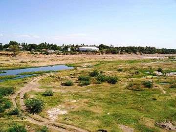 Part of the Amaravathy river basin near Karur | |
| Nickname(s): Heart of Tamilnadu | |
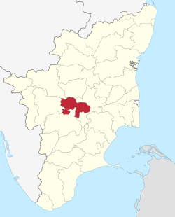 Location in Tamil Nadu, India | |
| Coordinates: 10°57′28.8″N 78°4′48″E / 10.958000°N 78.08000°ECoordinates: 10°57′28.8″N 78°4′48″E / 10.958000°N 78.08000°E | |
| Country |
|
| State | Tamil Nadu |
| Region | Kongunadu |
| Municipality | Karur |
| Municipality | Kulithalai |
| Town Panchayats | 11 |
| Headquarters | Karur |
| Taluks | 6 |
| Government | |
| • Collector | T.Anbalagan, IAS |
| • SP | T.K.Rajasekaran, IPS |
| Area | |
| • Total | 2,856 km2 (1,103 sq mi) |
| Population (2011) | |
| • Total | 1,076,588 |
| • Density | 373/km2 (970/sq mi) |
| Languages | |
| • Official | Tamil |
| Time zone | UTC+5:30 (IST) |
| PIN | 639xxx, 621xxx, 638xxx. |
| Telephone code | +91(0)4324, +91(0)4323, +91(0)4320 for Karur, Kulithalai and Aravakkurichi Circles Respectively. |
| Vehicle registration | TN 47 [1] |
| Largest city | Karur |
| Sex ratio | 1015 ♂/♀ |
| Literacy | 81.74% |
| Lok Sabha constituency | 2 – Karur, Perambalur (Part) |
| Vidhan Sabha constituency | 4 |
| Central location: | 10°57′N 78°4′E / 10.950°N 78.067°E |
| Climate | Max 38c – Min 17c (Köppen) |
| Website |
karur |
Karur District is a district located very centrally along the Kaveri and Amaravathi rivers in the Indian state of Tamil Nadu. The main town in Karur District is the city of Karur, which is also the district headquarters. The district had a population of 1,064,493 with a sex-ratio of 1,015 females for every 1,000 males.
History
Karur is one of the oldest towns in Tamil Nadu and has played a very significant role in the history and culture of the Tamils. . Its history dates back over 2000 years, and has been a flourishing trading center even in the early Sangam days. In the ancient and medieval times, the area was ruled by the Cheras, Gangas and Cholas. Karur was the capital of Cheras. The Pasupatheesvarar Temple sung by Thirugnana Sambhandar, in Karur was built by the Chola kings in the 7th century. Later the Nayakars followed by Tipu Sultan also ruled Karur. The British added Karur to their possessions after destroying the Karur Fort during their war against Tipu Sultan in 1783. There is a memorial at Rayanur near Karur for the warriors who lost their lives in the fight against the British in the Anglo-Mysore Wars.
Taluk and District formation
Post British annexure to Madras presidency, Karur became a taluk headquarters and was first part of Coimbatore District and later Tiruchirappalli District. A new district was formed on September 30, 1996 by furicating Karur, Kulithalai and Manapparai Taluks of Tiruchirappalli district, which comprises the present-day Aravakkurichi, Manmangalam, Karur, Krishnarayapuram, Kulithalai, Musiri, Kadavur and Manapparai Taluks.
Later, not less than a year, Musiri taluk was separated from Kulithalai taluk. Musiri and Manapparai taluks were reunited with Tiruchirapalli District. Karur Taluk was bifurcated to form Aravakkurichi and Karur taluks whereas Kulithalai taluk was bifurcated to form Krishnarayapuram and Kulithalai taluks.
Krishnarayapuram taluk is again bifurcated to form Kadavur taluk whereas Karur taluk also bifurcated to form Manmangalam taluk.
At the present day Karur District has 6 Taluks.
Geography and climate
With headquarters at Karur, it is the centrally located district of Tamil Nadu. It is bounded by Namakkal district in the north, Dindigul district in the south, Tiruchirapalli district on the east and Erode & Tiruppur districts on the west. Karur is located at 10°57'° N 78°4'° E has an average elevation of 122 metres (400 feet). It is about 371 km (231 mi) south west of Chennai (Madras), the state capital of Tamil Nadu.
The highest temperature is obtained in early May to early June usually about 34 °C (93.2 °F), though it usually exceeds 38 °C (100.4 °F) for a few days most years. Average daily temperature in Karur during January is around 23 °C (73.4 °F), though the temperature rarely falls below 17 °C (62.6 °F). The average annual rainfall is about 775 mm (30.5 in). It gets most of its seasonal rainfall from the north-east monsoon winds, from late September to mid November.
Demographics
According to 2011 census, Karur district had a population of 1,076,588 with a sex-ratio of 1,015 females for every 1,000 males, much above the national average of 929.[2] A total of 102,731 were under the age of six, constituting 52,969 males and 49,762 females. Scheduled Castes and Scheduled Tribes accounted for 20.8% and .05% of the population respectively. The average literacy of the district was 68.3%, compared to the national average of 72.99%.[2] The district had a total of 287,095 households. There were a total of 543,298 workers, comprising 83,800 cultivators, 182,639 main agricultural laborers, 10,162 in house hold industries, 231,906 other workers, 34,791 marginal workers, 2,072 marginal cultivators, 18,198 marginal agricultural laborers, 1,178 marginal workers in household industries and 13,343 other marginal workers.[3]
Administration and Politics
Karur district has 1 Municipal Corporation, 1 Second grade Municipality 11 Town Panchayats and 158 Village Panchayats and 203 Revenue Villages.
- Lok Shabha Constituencies
Karur District Comes under 2 Lok Shabha Constituencies
- Karur District Assembly Constituencies
- Aravakkurichi Assembly Constituency
- Karur Assembly Constituency
- Krishnarayapuram Assembly Constituency
- Kulithalai Assembly Constituency
- Karur District Revenue Divisions
The District is divided into 2 Revenue divisions namely Karur and Kulithalai each comprising 3 taluks.
- Karur District Sub Divisions (Taluks)
- Karur District Blocks
- K.Paramathy
- Aravakurichi
- Karur
- Thanthoni
- Kadavur
- Krishnarayapuram
- Kulithalai
- Thogaimalai
- Town Panchayats
- Aravakurichi
- Pallapatti
- Punjaipugalur
- TNPL Pugalur (Kagithapuram)
- Puliyur
- Uppidamangalam
- Palaya Jeyankondam
- Krishnarayapuram
- Marudur
- Nangavaram
Economy
Agriculture
Karur District is a part of cauvery delta region and utilization of land area in the district is up to 44.59%. 4.76% of the land area remains as other uncultivated land. 2.74% is forest area in Karur district. Black soil is the predominant soil type in this district accounting for 35.51% followed by laterite soil for 23.85%. The remaining 20.31% is sandy, coastal and alluvium soil. The main crops are paddy, banana, sugarcane, beetle leaf, grams & pulses, tapioca, kora grass, groundnuts, oilseeds, tropical vegetables, garland flowers, and medicinal herbs.
Home textiles
Karur is famous for its home textiles. Karur has a niche in five major product groups: bed linens, kitchen linens, toilet linens, table linens, wall hangings. Overall Karur generates around Rs.6000 crores in foreign exchange through direct and indirect exports. Allied industries like ginning and spinning mills, dyeing factories, weaving etc., employs around 450,000 people in and around Karur.
On the international textile map, Karur has become synonymous with hand loom made-ups products. The weaving industry came to Karur from Kerala and has earned a reputation for its high quality hand-loom products today. Hand loom exports from Karur began on a modest scale with just 15 exporters in 1975 and today Karur has thousands of exporters and the products are supplied to world leading chain stores like Walmart, Target, IKEA, Åhléns etc.
Paper
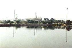
TNPL is promoted in TNPL Pugalur, by the Government of Tamil Nadu with loan assistance from the World Bank. Today TNPL is the largest producer of bagasse based paper in the world and the 2nd largest paper producer in Asia. TNPL produces 230,000 tons of Printing & writing paper and consumes 1 million tones of bagasse every year.providing more employment. It also has its finished products production plant at Mayanur.
Petroleum
Bharat Petroleum Corporation Limited (BPCL) has its terminal plant at Attur, near Karur.
Bus body building
Karur is a renowned hub for bus building industry. It is notable of Karur that almost 95% of south Indian private bus bodies are being built here. The total business is estimated to be around Rs.2750 crore per Annum. There are more than 200 builders in the district and they are making more than 3500 buses per year, including government buses of some states like Karnataka, Tamil Nadu etc.
Cement
Karur is also home to Chettinad Cements and TNPL Cements. Chettinad Cements has an installed production capacity of 600,000 tons per annum, with another 1.1 million tons expansion in the pipeline.
Sugar
EID Parry has a sugar factory unit at Pugalur. It has a capacity of 4000 TCD per year. It also has a 22 MW co-generation power plant, with TNPL.
Banking
The leading private scheduled banks Karur Vysya Bank and Lakshmi Vilas Bank have their headquarters in Karur.
Nylon nets
Around 65% of India's production of HDPE filament and associated products are from Karur district. These are widely used in fishing and fruit cultivating areas throughout South Asia.
Gem stones
The Karur belt also produces some very good amethyst, cat's eyes, feldspar, moonstones, aquamarines, sapphires, jasper and beryl.
Apart from these, there are 3 SIDCO industrial estates, a textile park namely, The Karur Textile Park Limited and many private contributing sectors like LGB Retreads, Rolon Chains, VKA Polymers, Shobika Impex, VKA Diary etc., Have their Headquarters or Production units in Karur District.
Tourism and places of interest
Picnic spots
- Mayanur – Kaveri bed regulator, Dam and River side park
- Chettipalayam – Amaravathi bed regulator, park
- Tirumukkudalur – Kaveri and Amaravathi rivers coincide here
- Nerur – Sacred muut, Meditation, River side park
- Kadavur – Ponnaniyar dam, park
- Rengamalai – Devotional, Trekking
Temples
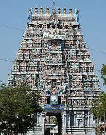

- Shree Kalyana Pasupatheeswarar Temple (Thiru Aanilai), Karur
- Shree Abayapradhana Ranganathar Temple, Karur
- Shree Karuvur Mariyamman Temple, Karur
- Thanthondrimalai Shree Kalyana Venkataramanaswamy Temple
- Shree Balasubramania Swamy Temple, Vennaimalai
- Pugazhimalai Shree BalasubramaniaSwamy Temple (Aaru Naatar Malai)
- Balamalai Shree Balathandayuthapani Temple
- Vanjeleeshwarar Temple, Karur
- Koteeshwarar Temple, Karur
- Venjamangudalur Vigirtheeswarar Tempe
- Velliyanai-Shree kalyana Pressana Venkatramana Perumal Samy Temple
- Aravakkurichi Kasi visvanathar Temple
- Nerur Shree Sadhasiva Bhrameendhraal Mutt, Kasi VishwanatharTemple
- Nerur Agneeshwarar Temple
- Madhukkarai Sellandiyamman Temple
- Chinna Darapuram Munimukktheswarar Temple
- Krishnarayapuram Tirukkanmalleswarar Temple
- Kadavur Vasantha perumal Temple
- Veerappur Kannimaramman, Ponnar Sankar Temple
- Kulithalai Kadambar Temple
- Kulithalai Neelameegha perumal Temple
- Iyermalai Rathinagireeshwarar Temple
- Sivayam Sivapurishwarar Temple
- karuppathur Iyyapan Temple (1st Iyyapa Temple in Tamil Nadu)
- karuppathur Simmapureeswarar Temple
- Mahanadhapuram Mahalakshmi Amman temple
- Togamalai Murugan Temple
- Tirumukkudalur Agastheeshwarar Temple
- Rangamalai Malleeshwarar Temple
- Puliyur Vyakarapuriswarar temple
- Uppidamangalam Adiyaarkku ealiyaar Temple
- Kodanthur Shree Rajalinga MOORTHI temple
- Rangamalai Malleshwaran Temple
Health
Karur district has 1 Government Medical College Hospital, 5 Government General Hospitals, 29 Primary Health Care centres, 168 health sub-centres. In recent years, it has gained notoriety as one of the districts with the highest prevalence of HIV/AIDS in the country. In response to the epidemic, a massive district-level communication campaign (DLCC) was launched in 2006 by the USAID-funded APAC-VHS project in the district. In 2007, the district received its own ART (Antiretroviral drug therapy) Centre, located at the Government General Hospital. Also in 2007, Karur was selected as an IMAI pilot district by the World Health Organization and Solidarity and Action against the HIV Infection in India, with support from the District Collectorate and Tamil Nadu AIDS Control Society.
Transportation
Road
Karur is connected with the rest of India through all modern means of transportation. The International highway AH-43 pass away here.There are two national highways: NH-44 (North South Corridor Road (Kashmir to Kanyakumari)) Srinagar – Kanyakumari and NH-67 (Nagapattinam – Trichy – Karur – Coimbatore – Gudalur), which connect with other major towns such as Chennai, Erode, Tiruppur, Pollachi, Hosur, Tuticorin, Dindigul, Theni, Vellore, Palani, Tanjore, Karaikudi, Kumbakonam, Kochi, and Pondicherry. There are new highway construction projects under work.
Train
Karur Junction railway station (Station Code – KRR) is an important railway junction in the state, connected to the Indian Railways network. Apart from this, There are 17 other stations lies across Erode-Tiruchirappalli line and Template:Salem-Karur-Dindigul line which connects all other parts of the country. More than 30 Express and Passenger trains ply through Karur Daily.
Airport
The nearest airport is in Tiruchirappalli Airport (85 km), Coimbatore Airport (130 km) and Madurai Airport (135 km).
Sea port
The nearest major sea port is at Thoothukudi (280 km), Chennai (372 km) and Cochin(344 km).
See also
References
- ↑ www.tn.gov.in
- 1 2 "Census Info 2011 Final population totals". Office of The Registrar General and Census Commissioner, Ministry of Home Affairs, Government of India. 2013. Retrieved 26 January 2014.
- ↑ "Census Info 2011 Final population totals - Karur district". Office of The Registrar General and Census Commissioner, Ministry of Home Affairs, Government of India. 2013. Retrieved 26 January 2014.
External links
| State symbols |
|
|---|---|
| Governance |
|
| Topics | |
| Districts |
|
| Major cities | |
| Wikimedia Commons has media related to Karur district. |