Dharmapuri district
| Dharmapuri District | |
|---|---|
 | |
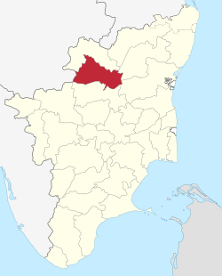 Location in Tamil Nadu, India | |
| Coordinates: 12°7′33.6″N 78°9′14.4″E / 12.126000°N 78.154000°ECoordinates: 12°7′33.6″N 78°9′14.4″E / 12.126000°N 78.154000°E | |
| Country |
|
| State | Tamil Nadu |
| Established | Oct 02, 1965 |
| Founded by | Adhiyaman King |
| Headquarters | Dharmapuri |
| Taluks |
Dharmapuri, Harur, Karimangalam, Nallampalli, Palakcode, Pappireddipatti, Pennagaram |
| Government | |
| • District Collector | S. Malarvizhi, IAS |
| • Superintendent of Police | Bandi Gangadhar, IPS |
| Area | |
| • Total | 4,497.77 km2 (1,736.60 sq mi) |
| Area rank | 11 |
| Population (2011) | |
| • Total | 1,506,843 |
| • Rank | 24 |
| • Density | 340/km2 (870/sq mi) |
| Languages | |
| • Official | Tamil |
| Time zone | UTC+5:30 (IST) |
| PIN | 636 701 |
| Telephone code | 04342 |
| ISO 3166 code | ISO 3166-2:IN |
| Vehicle registration | TN-29[1] |
| Largest city | Dharmapuri |
| Largest metro | Dharmapuri |
| Central location: | 12°7′N 78°9′E / 12.117°N 78.150°E |
| Website |
dharmapuri |
Dharmapuri is a district in western part of Tamil Nadu in South India. It is the first district created in Tamil Nadu after the independence of India by splitting it from then-Salem district on 02 October, 1965. The other major towns in the district are Harur, Palacode, Karimangalam, Pennagaram and Pappireddipatti. Dharmapuri District is one of the major producers of mango in the state, fine quality granite is found in the district. It is also one of the main sericulture belts in the state. Around 30 percent of the district's area is under forest cover. Cauvery river enters Tamil Nadu through this district.
Etymology
Dharmapuri was called Tagadur during the Sangam era. The name Tagadur is derived from two Tamil words, "Thagadu" meaning iron (iron ore), and "Oor" meaning "place". The name Tagadur was changed to Dharmapuri after the Sangam period, possibly during the period of the Vijayanagara Empire or the period of the Kingdom of Mysore. The name Tagadur is still used by some of the people of Dharmapuri.
History
The region is believed to have been controlled by the Pallava dynasty in the 8th century. The Rashtrakutas took over in the 9th century. They were defeated by the Cholas in the 11th century, and subsequently the district came under the Chola sphere of governance.[2]
During 18th century present day Dharmapuri district was part of the Kingdom of Mysore and was called Baramahal. As part of the Treaty of Seringapatam (signed on 18 March 1792) after the Third Anglo-Mysore War, Tipu Sultan agreed to give part of his territories including present-day Dharmapuri district to the British East India Company which was then merged into the Madras Presidency an administrative subdivision of British India.
It was part of the Salem District under British rule, until the founding of Dharmapuri district on 2 October 1965. The Dharmapuri district was split into Dharmapuri and Krishnagiri districts in 2004.[2] Many historical rock sculptures are found in this district. Modhur, a village near Dharmapuri has remains that date back to the Neolithic age. A government museum in Dharmapuri town displays some of these significant sculptures.
Geography
The district is located between latitudes N 11 47’ and 12 33’ and longitudes E 77 02’ and 78 40’. Occupies an area of 4,497.77 km2 (1,736.60 sq mi) (i.e. 3.46% of Tamil Nadu). It is bounded on the north by Krishnagiri District, on the east by Tiruvannamalai District and Viluppuram District, on the south by Salem District, and on the west by Karnataka's Chamarajanagar District. The whole district is surrounded by hills and forests, and the terrain is of rolling plains type. Dharmapuri is located in the geographically important area in south India.
Forests
The whole district is predominantly covered with forests. Spider Valley located near Hogenakkal is home to many wild animals. The district falls in the migratory path of elephants. Conflicts between man and elephant are most common in these parts. Many tribal communities depend on these forests. Vathalmalai, a mountain hamlet on top of Shervarayan hill chain has suitable conditions to cultivate coffee and jackfruit. Wild boars and spotted deer are commonly seen in Morappur and Harur forest region. Gaurs sometimes stroll near villages in the Bommidi region. Thoppur ghat has one of the area's scenic highways surrounded by mountains and forests.
Governance
Dharmapuri is the district headquarters. The district has been divided into two revenue divisions namely Dharmapuri and Harur consisting seven taluks.
Administrative divisions
Revenue divisions: Dharmapuri and Harur.
Revenue taluks: Dharmapuri, Harur, Karimangalam, Nallampalli, Palacode, Pappireddipatti, Pennagaram.
Town Panchayats: Harur, Marandahalli, Bommidi, Palakkodu, Pennagaram, Karimangalam, Kambainallur, Papparapatti, Kadathur, Pappireddipatti.
Panchayat Unions: Dharmapuri, Harur, Nallampalli, Palakkodu, Pennagaram, Karimangalam, Morappur, Pappireddipatti.
Demographics
According to 2011 census, Dharmapuri district had a population of 1,506,843 with a sex-ratio of 946 females for every 1,000 males, much above the national average of 929.[3] A total of 167,940 were under the age of six, constituting 87,777 males and 80,163 females. The average literacy of the district was 91.2% compared to the national average of 72.99%.[3] The district had a total of 375,873 households. There were a total of 751,170 workers, comprising 191,080 cultivators, 217,062 main agricultural labourers, 11,308 in house hold industries, 233,546 other workers, 98,174 marginal workers, 10,248 marginal cultivators, 50,283 marginal agricultural labourers, 4,033 marginal workers in household industries and 33,610 other marginal workers.[4] The population of the district is roughly equal to the nation of Gabon[5] or the US state of Hawaii.[6]
Economy
Agriculture

Dharmapuri and Krishnagiri districts account for more than 60 -70% total mango production in Tamil Nadu.[7] It is a major producer of Ragi and saamai crops in the state. Exotic crops like dates are also being cultivated by some farmers in the areas around Ariyakulam.
| Crop | Area under cultivation(in hect.) | in % |
|---|---|---|
| Paddy (Sornavari / Kuruvai / Kar / Samba / Thallady / Pisanam/ Navarai / Kodai) | 9,465 | 5.60% |
| Millets(Ragi) | 18,243 | 10.80% |
| Other Minor Millets | 69,162 | 40.90% |
| Pulses | 40,441 | 23.90% |
| Sugar Cane | 11,971 | 07.10% |
| Mango | 6,506 | 03.80% |
| Coconut | 7,037 | 04.20% |
| Tamarind | 1,197 | 00.70% |
| Other Crops | 5,067 | 03.00% |
| Total | 1,69,089 | km |
Education
Dharmapuri district shows increasingly improved performances in literacy and education. In the year 2011 it was in last position in Tamil Nadu with a score of 62%, whereas by the year 2016 it showed a 92% literacy rate and ranked 12th in Tamil Nadu out of 32. It also showed an increase in educational hubs by having colleges and school in various fields of education. Some of the major educational institutes are given below.
Medical Fields
- Government Dharmapuri Medical College (GDMC)
- DNV College of Nursing
- Sri Vijay Vidyalaya College of Nursing.
- Swami Vivekananda College of Nursing.
Engineering Fields
- Government College of Engineering, Dharmapuri
- Jayam College of Engineering
- Jayalakshmi Institute of Technology
- Sapthagiri College of Engineering
- Shreenivasa College of Engineering
- Varuvan Vadivelan Institute of technology.
Law College
there is no Law College in Dharmapuri.
Arts & Science colleges
Dharmapuri district has around 30 arts and science colleges, including women's colleges.(PMP ARTS & SCIENCE COLLEGE) 1 Vijay VIdhyalaiya College of Arts & Science (Womens) 2 Laksmi narayana College of Arts & Science (Womens) 3.Pachamuthu College of Arts & Science (Womens) 4.Jai shree venkatesha College of Arts & Science 5.P.s.a College of Arts & Science 6. venkateswara College of Arts & Science 7. Don Bosco College of Arts and Science
Periyar University
Periyar University College of Arts and Science, in Pappireddipatti
CBSE & ICSE schools
Dharmapuri district has around 12 schools including Central Board of Secondary Education (CBSE) and Indian Certificate of Secondary Education (ICSE).
TN Board schools
Dharmapuri district has more than 500 Tamil Nadu Board-based schools, including both government and private schools.
Tourism
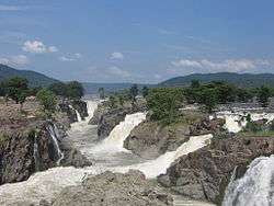
Hogenakkal Falls is located in the Dharmapuri district. Medicinal baths, boat rides, oil massage, fish fiesy and water falls in the hills make it a tourist attraction. Sometimes referred to as the "Niagara Falls of India," Carbonatite rocks in this site are considered to be the oldest of their kind in South Asia and some of the oldest in the world.[8] The Government of Tamil Nadu proposed converting the falls to providing drinking water for the state. The Kaveri river flows into the state through the district, and Hogenakkal, a town situated 46 km (29 mi) from Dharmapuri is the site where the river drops as a scenic waterfall.
Vathalmalai or Vytla Hills (Tamil: வத்தல்மலை) is a hill station in Dharmapuri district in Tamil Nadu. It is situated at an altitude of 1,418 m (4,652 ft) height above sea level. It is located 25 km (16 mi) from Dharmapuri city and the road has 26 hairpin bends to reach hill top. It covers an area measuring nearly 225 km2 (87 sq mi). The climate of the Vytla Hills has a moderate humid subtropical climate (Köppen:Cwa). Winters are fairly mild, beginning in December and ending in February. During winter, the hills are covered in mist. Winters range from 7–18 °C (45–64 °F), and summers from 15–28 °C (59–82 °F). Rainfall is 1,500–2,000 mm (59–79 in). Coffee bushes blossom in April. The climate is also particularly pleasant. Most of the native flora and fauna of Vytla have disappeared due to severe habitat fragmentation resulting from the creation of the plantations. However, some species continue to survive and thrive in several protected areas nearby, include the Sheverayan Hills (Yercaud). These protected areas are known for several threatened and endemic species including Nilgiri tahr (Ibex), the Grizzled Giant Squirrel, the Nilgiri Wood-pigeon, the Gaur, wild pig, the Nilgiri langur, the Sambar deer and the Neelakurinji (that blossoms only once every seven years).[9]
Hill-temple at Theerthamalai in Harur taluk is a sacred religious site for Hindus, and has been in existence from the times of the Chola and the Vijayanagara empires.[10]
Adhiyamankottai: Tourists visiting the site can see ruins of the roughly oval-shaped fort. Also close to this site is the Chenraya Perumal Temple, which is believed to have been constructed by King Krishnadevaraya as well as the Hoysala kings. The Mandapam within the temple leads to the sanctum sanctorum, where there are paintings depicting the scenes from the Mahabharata and the Ramayana. The Kalabairavar Temple is also located here.
Kottai Kovil located on the northern side of Dharmapuri, is a temple dedicated to Lord Shiva. This temple is known for its rare sculptures and paintings. One of the main features of this temple is the "hanging pillar". The locals believe that a secret passage in this temple connects it to Adhiyamankottai.
Dharmapuri Archaeological Museum contains many historical objects.
Sri Hanuman (Anjaneya) Temple at Muthampatti is located 14 km (8.7 mi) from Dharmapuri City in a forest near Muthampatti Railway Station (2 km (1.2 mi)).
Also the Nagavadhi Dam and the Thoppayaru Dam (located nearby Thoppur, Dharmapuri) and more dams can be visited by tourists.
B. Agraharam Muniyappan Temple festival is celebrated every year in the Tamil month Margali middle week Tuesday.
References
- ↑ www.tn.gov.in
- 1 2 "History of Dharmapuri District". Dharmapuri District Official TN Website. Retrieved 1 March 2014.
- 1 2 "Census Info 2011 Final population totals". Office of The Registrar General and Census Commissioner, Ministry of Home Affairs, Government of India. 2013. Retrieved 26 January 2014.
- ↑ "Census Info 2011 Final population totals – Dharmapuri district". Office of The Registrar General and Census Commissioner, Ministry of Home Affairs, Government of India. 2013. Retrieved 26 January 2014.
- ↑ US Directorate of Intelligence. "Country Comparison:Population". Retrieved 2011-10-01.
Gabon 1,576,665
- ↑ "2010 Resident Population Data". U. S. Census Bureau. Archived from the original on 2013-10-19. Retrieved 2011-09-30.
Hawaii 1,360,301
- ↑ "Mango cultivation in TamilNadu(Dharmapuri & Krishnagiri Districts)". National Horticulture Board, Government Of INDIA.
- ↑ Natarajana, M; Bhaskar Rao, B; Parthasarathy, R; Kumar, Anil; Gopalan, K (1994). "2.0 Ga old pyroxenite-carbonatite complex of Hogenakkal, Tamil Nadu, South India". Precambrian Research. 65 (1–4): 167–81. doi:10.1016/0301-9268(94)90104-X. INIST:3910799.
- ↑ "Wonder flower in bloom again". thehindu.com. Retrieved 3 March 2018.
- ↑ "Dharmapuri". tamilnadutourism.org. Retrieved 1 March 2014.
External links
- Dharmapuri District's Government website
- Dharmapuri District's Support website
- Dharmapuri- Idhu Namba Ooru Machi
| District Headquarters |  | |
|---|---|---|
| State | ||
| Region | ||
| Taluks | ||
| Blocks | ||
| Town panchayats | ||
| Places of interest | ||
| ||
| State symbols |
|
|---|---|
| Governance |
|
| Topics | |
| Districts |
|
| Major cities | |