Thanjavur district
| Thanjavur district Chola Nadu | |
|---|---|
| District | |
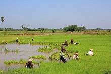
 Rural landscape near Peravurani | |
| Nickname(s): Thanjai Jilla/தஞ்சை ஜில்லா | |
 Location in Tamil Nadu, India | |
| Coordinates: 10°47′8.16″N 79°8′24.36″E / 10.7856000°N 79.1401000°ECoordinates: 10°47′8.16″N 79°8′24.36″E / 10.7856000°N 79.1401000°E | |
| Country |
|
| State | Tamil Nadu |
| Municipal Corporations | Thanjavur |
| Headquarters | Thanjavur |
| Talukas |
Budalur, Kumbakonam, Orathanadu, Papanasam, Pattukkottai, Peravurani, Thanjavur, Thiruvaiyaru, Thiruvidaimarudur |
| Government | |
| • District Collector | A. Annadurai IAS[1] |
| • Superintendent of Police | J.Mahesh IPS[2] |
| Population (2011) | |
| • Total | 2,405,890 |
| Languages | |
| • Official | Tamil |
| Time zone | UTC+5:30 (IST) |
| PIN | 613xxx |
| Telephone code | 04362,0435 |
| ISO 3166 code | ISO 3166-2:IN |
| Vehicle registration | TN-49,TN-68[3] |
| Website |
thanjavur |
Thanjavur District is one of the 32 districts of the state of Tamil Nadu, in southeastern India. Its headquarters is Thanjavur. The district is located in the delta of the Cauvery River and is mostly agrarian. As of 2011, Thanjavur district had a population of 2,405,890 with a sex-ratio of 1,035 females for every 1,000 males.
Geography

The district is located at 10°05′N 79°10′E / 10.08°N 79.16°E in Central Tamil Nadu bounded on the northeast by Nagapattinam District, on the east by Tiruvarur District, on the south by the Palk Strait, of Bay of Bengal on the west by Pudukkottai District and Tiruchirappalli, and on the north by the river Kollidam, across which lie part of Tiruchirappalli, and Ariyalur districts.
Demographics
According to 2011 census, Thanjavur district had a population of 2,405,890 with a sex-ratio of 1,035 females for every 1,000 males, much above the national average of 929.[4] A total of 238,598 were under the age of six, constituting 121,949 males and 116,649 females. Scheduled Castes and Scheduled Tribes accounted for 18.91% and .15% of the population respectively. The average literacy of the district was 74.44%, compared to the national average of 72.99%.[4] The district had a total of 605,363 households. There were a total of 974,079 workers, comprising 117,321 cultivators, 327,673 main agricultural labourers, 26,430 in house hold industries, 363,060 other workers, 139,595 marginal workers, 12,592 marginal cultivators, 87,688 marginal agricultural labourers, 4,770 marginal workers in household industries and 34,545 other marginal workers.[5]
Economy
Agriculture
Thanjavur district lies in the Kaveri delta, the most fertile region in the state.[6] The district is the main rice producing region in the state and hence known as the Rice Bowl of Tamil Nadu.[7] Kaveri River and its tributaries irrigate the district. Apart from paddy, farmers here grow coconut and sugarcane and it is the largest producer of coconut in Tamil Nadu.Being an agrarian economy, industrial growth in the district is mainly confined to agro-based industries. A large number of Rice mills, Oil mills are spread over the district.
Tourism
Brihadeeshwarar Temple
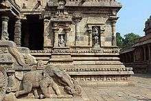
Brihadeeshwarar Temple also called as Peruvudaiyaar Temple, built by the Cholas and a UNESCO World Heritage Site is located at Thanjavur. The green paddy fields and the Kaveri river provide for picturesque spots in the district.
Airavateswara temple near Kumbakonam is also a UNESCO declared World Heritage site and another major tourist attraction in the district.
Flora
Thanjavur flora was explored and studied by S.A Ganapathy in 1992.[8]
Cultural Significance
Thanjavur is famous for the "Saraswathi veena" (the national instrument), Thanjavur art plates, Thanjavur oil paintings and Thalaiyatti Bommai.
Notable people
See also
Notes and references
- ↑ district Collector
- ↑ City Superintendent of Police
- ↑ www.tn.gov.in
- 1 2 "Census Info 2011 Final population totals". Office of The Registrar General and Census Commissioner, Ministry of Home Affairs, Government of India. 2013. Retrieved 26 January 2014.
- ↑ "Census Info 2011 Final population totals – Thanjavur district". Office of The Registrar General and Census Commissioner, Ministry of Home Affairs, Government of India. 2013. Retrieved 26 January 2014.
- ↑ Nathan, K. K. (October 1995). "Assessment of Recent Droughts in Tamil Nadu" (PDF). Drought Network News. Archived from the original (PDF) on 17 March 2003.
- ↑ "Welcome to Thanjavur (District Official Website)". District Administration of Thanjavur.
- ↑ Ragupathy, Subramanyam (1992). Flora of Thanjavur District. Doctoral dissertation, PhD thesis. Madras, India: Centre for Advanced Study in Botany, University of Madras.
External links
| Wikimedia Commons has media related to Thanjavur district. |
| State symbols |
|
|---|---|
| Governance |
|
| Topics | |
| Districts |
|
| Major cities | |
| District headquarters |  | |
|---|---|---|
| Country | ||
| State | ||
| Region | ||
| Divisions | ||
| Taluks | ||
| Revenue blocks | ||
| Municipal Corporations | ||
| Municipalities | ||
| Rivers | ||
| History | ||
| Places of interest |
| |
| Religious and monastic institutions | ||
| Universities | ||
| ||
| Rank | Taluk | Pop. | |||||||
|---|---|---|---|---|---|---|---|---|---|
.jpg) Thanjavur  Kumbakonam |
1 | Thanjavur | Thanjavur taluk | 290,724 | |||||
| 2 | Kumbakonam | Kumbakonam taluk | 167,098 | ||||||
| 3 | Pattukkottai | Pattukkottai taluk | 65,553 | ||||||
| 4 | Adiramapattinam | Pattukkottai taluk | 31,066 | ||||||
| 5 | Peravurani | Peravurani taluk | 21,035 | ||||||
| 6 | Papanasam | Papanasam taluk | 16,397 | ||||||
| 7 | Madukkur | Pattukkottai taluk | 15,436 | ||||||
| 8 | Thiruvaiyaru | Thiruvaiyaru taluk | 14,535 | ||||||
| 9 | Vallam | Thanjavur taluk | 14,495 | ||||||
| 10 | Ayyampettai (Thanjavur district) | Papanasam taluk | 14,202 | ||||||