Anjaneri
| Anjaneri | |
|---|---|
 Anjineri fort Nasik | |
| Highest point | |
| Elevation | 1,280 m (4,200 ft) |
| Coordinates | 19°55′N 73°34′E / 19.92°N 73.57°ECoordinates: 19°55′N 73°34′E / 19.92°N 73.57°E |
| Geography | |
 Anjaneri Location of Anjaneri, Maharashtra | |
| Location | Nashik, Maharashtra, India |
| Parent range | Trimbakeshwar |
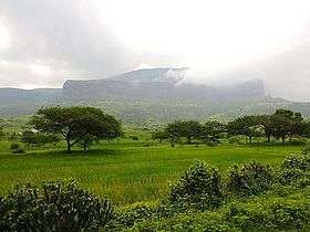
Anjaneri is one of the forts in the mountain range of Nasik-Trimbakeshwar. Anjaneri is located 20 km away from Nasik by Trimbak Road.
History
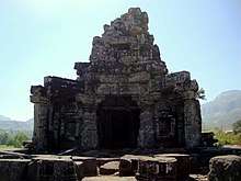
Jain temple

Hindu mythology says Hanuman was the incarnation of Shiva, the god of destruction.[1]
Anjaneri is an attraction of Nasik city, which is also an important fort in the Trimbakeshwar region. Situated at 4,264 feet (1,300 m) above sea level, it lies between Nasik and Trimbakeshwar.
Anjaneri is the birthplace of Hanuman, and is named after Hanuman's mother, Anjani.[2]
108 Jain caves are found here belonging to 12th century. The area around Anjaneri was once ruled for a brief period by Veersen Ahir (also spelled Abhir), who made it his capital.[3]
References
- ↑ "AboutShiva.com - About Shiva - Hanuman Jayanthi". About Shiva. 2009-04-09. Retrieved 2012-10-29.
- ↑ "Anjaneri, Trimbakeshwar". Must See India. Retrieved 5 February 2012.
- ↑ Rameśa Desāī (1987). Shivaji, the Last Great Fort Architect. Maharashtra Information Centre, Directorate-General of Information and Public Relations, Government of Maharashtra. p. 57.
This article is issued from
Wikipedia.
The text is licensed under Creative Commons - Attribution - Sharealike.
Additional terms may apply for the media files.