Namakkal district
| Namakkal District | |
|---|---|
| District | |
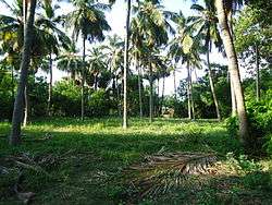 Palm Trees, Thiruchengode | |
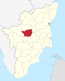 Location in Tamil Nadu, India | |
| Coordinates: 11°13′8.4″N 78°10′1.2″E / 11.219000°N 78.167000°ECoordinates: 11°13′8.4″N 78°10′1.2″E / 11.219000°N 78.167000°E | |
| Country |
|
| State | Tamil Nadu |
| Headquarters | Namakkal |
| Taluks | Namakkal, Paramathi Velur, Rasipuram, Thiruchengode, Kumarapalayam, Kolli Hills, Sendamangalam, Mohanur |
| Government | |
| • District Collector | M. Asia Mariam, IAS |
| • Superintendent of Police | Ara Arularasu, IPS |
| Area | |
| • Total | 3,368.21 km2 (1,300.47 sq mi) |
| Population (2011) | |
| • Total | 1,726,601 |
| • Density | 510/km2 (1,300/sq mi) |
| Languages | |
| • Official | Tamil |
| Time zone | UTC+5:30 (IST) |
| PIN | 637xxx |
| Telephone code | 04286 |
| ISO 3166 code | ISO 3166-2:IN |
| Vehicle registration | TN-28, TN-88, TN-34[1] |
| Nearest districts | Salem, Trichy, Erode, Karur |
| Central location: | 11°13′N 78°10′E / 11.217°N 78.167°E |
| Website |
namakkal |
Namakkal District is an administrative district in the state of Tamil Nadu, India. The district was bifurcated from Salem District with Namakkal town as headquarters on 25 July 1996 and started to function independently from 1 January 1997. The district has seven taluks (subdivisions): Tiruchengode, Namakkal, Rasipuram, Paramathi-Velur, Sendamangalam, Komarapalayam, Kolli Hills and Mohanur. It has two revenue divisions: Namakkal and Tiruchengode. As of 2011 census, Namakkal district had a population of 1,726,601 with a sex-ratio of 986 females for every 1,000 males. Namakkal district is geographically affiliated to Kongu Nadu region. to The district is famous for its large poultry industry, egg production and lorry body-building industry, for which it is often referred to as "Egg City" and "Transport City".
History
After the struggle between the Cheras, Cholas, and Pandyas, the Hoysalas rose to power and had the control until the 14th century, followed by Vijayanagara Empire until 1565 AD. Then, the Allala Ilaya Nayakas vettuva king came to power in 1623 AD. Two of the Poligans of Tirumalai Nayak namely, Ramachandra Nayaka ruled the Salem area. The Namakkal fort is reported to have been built by Ramchandra Nayaka. After about 1635 AD. Valvil Ori was a chieftain and one of the seven patrons from Sangam age who ruled over Kolli Hills around 200 AD.
Geography
Namakkal district covers an area of 3,368.21 km2. The district is bounded by Salem district on the north; on the east by Attur taluk of Salem district, Perambalur and Tiruchirapalli District's, by Karur District on the south and on the west by Erode district[2].The average annual rainfall is 716.54 mm. This district receives rainfall mainly from North East Monsoon.
Namakkal District comes under the North Western Agro climatic zone of Tamil Nadu.Tiruchengode taluk alone is placed under Western Agro-climatic zone.[3]The forest cover has an area of 512.5 km2, which is 15.4% of the total area.[4] Temperature ranges between maximum of 40’C and minimum of 18’C.
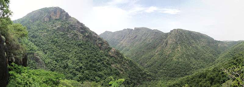
Besides the above two zones, Kolli Hills (a part of the Eastern Ghats mountain range) and a few isolated hills and ridges are scattered over Namakkal, Rasipuram, and Tiruchengode and along with the valleys and rolling hills, make up the characteristic topography of the district.
The river Kaveri flows south and southwest hugging the district's borders with Karur and Erode. The other rivers flowing though the district are Aiyaru, Karipottan Aaru and Thirumanimutharu.
Irrigation
The district is situated in the dividing portion of two watersheds between Cauvery and the Vellar System with the Taluks of Attur, Rasipuram and Namakkal on the East and Salem, Omalur and Mettur on the West. Mettur East Bank canal irrigates Pallipalayam Block with an area of 4585 Ha. Rajavaikal canal irrigates an area of 4215 Ha. Mohanur vaikal irrigates about 355 Ha. Kumarapalayam vaikal irrigates about 1146 Ha and Poiyeri vaikal irrrigates about 323 Ha.
Demographics
According to 2011 census, Namakkal district had a population of 1,726,601 with a sex-ratio of 986 females for every 1,000 males, much above the national average of 929.[5] A total of 150,699 were under the age of six, constituting 78,754 males and 71,945 females. Scheduled Castes and Scheduled Tribes accounted for 20.% and 3.3% of the population respectively. The average literacy of the district was 68.12%, compared to the national average of 72.99%.[5] The district had a total of 475,511 households. There were a total of 898,245 workers, comprising 152,497 cultivators, 228,614 main agricultural labourers, 35,156 in house hold industries, 422,885 other workers, 59,093 marginal workers, 5,976 marginal cultivators, 25,112 marginal agricultural labourers, 3,641 marginal workers in household industries and 24,364 other marginal workers.[6]
Industry and Economy
Agriculture
The main occupation for most of the people in the district is agriculture, with a gross cropped area of around 0.3367 million Ha, out of which about 60,939 Ha are irrigated and about 80,598 Ha are rainfied. The cultivation generally depends on monsoon rains, wells, and tanks. Major soil in this district is red soil (77%). Nearly 90 percent of the cultivated area is under food crops. The principal cereal crops of this district are paddy, cholam, cumbu and ragi. Panivaragu, Kuthiraivali, Samai Varagu and Thinai are some of the millets cultivated. Among pulses, the major crops are redgram, blackgram, greengram and horsegram. Among oil, seeds, groundnut, castor, and gingelly (sesame) occupy important places. Of the commercial crops, sugarcane, cotton and tapioca are some of the important. Using tapioca as raw material about 350 factory units are engaged in the production of Starch and Sago in Namakkal District.
Lorry Body-Building
Namakkal district is noted for truck and lorry external body building industry which dates back to 1956. Nationwide Namakkal is known for body building for truck, trailer, tanker and rig unit. Throughout India, Tiruchengode is known for its body building industry for trucks, trailers, tankers, and rig units. Finished trucks and rig units are exported to foreign countries from Namakkal. Nearly 25000 people are employed, both directly and indirectly, in truck body building activity and about 300 units in Namakkal and 100 units in Tiruchengode are engaged in this activity.[3]
Ashok Leyland's Driver Training Institute in Namakkal (right in the trucking heartland of Tamil Nadu) was the first of its kind and has served as a beacon to lead the way in the training of drivers. Easily accessible from Erode, Salem and Trichy, and spread over 25 acres, the campus includes a driving range with every conceivable road configuration. A spacious building accommodates large classrooms, a library, a model room, a laboratory and a cafeteria with an open-air theatre attached. The roads come with electronic signals, signs, markings and streetlights for night driving – everything, in fact, that drivers will encounter on the highways.
Poultry
Poultry plays an important role in the economy of Namakkal[7] which has an astounding number of 29.3 miiliion fowls and 32.4 million eggs produced every day[4], accounting for a bulk of supply of poultry products to neighbouring industries. Namakkal produces about 65% of the total egg output of Tamil Nadu.[8] About 1500 Poultry/Cattle Feed manufacturing units are also in existence. Mostly every poultry unit has put up their own feed manufacturing unit.
Others
Nearly 176 Sago factories are located in and around the Rasipuram Taluk.[7] Bore-wells and textile are the main business in Tiruchengode. Nearly 37 spinning mills and more than 10.000 powerlooms are functioning in Tiruchengode. One sugar mill and one paper mill were functioning under Private Sector.
Culture and Tourism
Namakkal Rock Fort and Hindu temples around
The town of Namakkal is built around a rock fort. The rock fort is on the summit of the rock, and the remnants in brick and stone still bear the brunt of the skirmishes to lay siege to the fort by the Cholas in the 9th century.[3] There are two rock–cut cave temples located on both sides of the hill dedicated to Narasimhaswamy and Ranganathaswamy. The caves were constructed by Adhiyaman rulers who ruled over Kongu Region during the 7th Century. The Temple have been declared as monuments under the preservation of Monuments and sites Act 1958 and being administered by the HR&CE department of Government. A temple dedicated to the Goddess Namagiri Amman is situated within the temple complex of the Narasimha Swamy kovil.[9]
The famous Namakkal Digambara Anjaneyar Temple, housing an 18-foot-tall Hanuman statue is located opposte to the Narasimhaswamy temple. It is believed that the Hanuman statue keeps growing and to stop the growth a priest put a magic needle at the top of the statue's head. Hanuman statue carved out of a single stone at this temple.[9]
Some of the notable temples in the district are:
- Sri Palapattarai Mariamman Temple- Namakkal
- Sri Maruthakaliamman Temple- Namakkal
- Sri Ardhanareeswarar Temple- Tiruchengode and Mohanur
- Sri Navaladi Karuppannaswami Temple – Mohanur
- Sri Sundakka Sellandiamman Temple - Mohanur
- Sri Ettukaiamman Temple – Keerambur and Kolli Hills
- Sri Selliamman Temple - Konnayar
- Sri Ponkaliamman Temple - Kokkalai
- Sri Athayiammam Temple - Iluppili (Iruppul)
- Sri Rasaaswamy, Rasayiamman Temple - Nanjai edayar
- Sri Alagu Nachiyamman Temple - Paruthipalli
- Sri Karupannasamy Temple - Oonchapalayam (Oonchakadu), P.Velur
- Sri Aleya Elankai Amman Temple (Aya kovil) - Koonavelampatti[10]
Tiruchengode
Tiruchengode is 35 km from Namakkal. It is one of the seven Sivasthalams in Kongunadu. The Ardhanareeswarar temple is located on a hill. The presiding deity is depicted as half-male and half-female, vertically to represent Shiva and Parvati worshipped as one form. It is considered one of the oldest temples in this region.
Tiruchegode is the olden Poondurainadu in Kongunadu. Tiruchengode olden name is Thirukodimadachengondurur.
Kollimalai (Kolli Hills)
Kolli Hills are at an altitude of 1200 metres in the Namakkal District and are 45 km from Namakkal town. The Kolli hills are featured in several works of classical Tamil literature such as Silappathigaram, Manimekalai, Purananuru and Ainkurnuru.The region was ruled by Valvil Ori whose valor and marksmanship are sung by several poets, and his exploits are a popular part of folklore.
There are three reserved forests that are controlled by the Government of Tamil Nadu, namely Ariyur Solai, Kundur Nadu and Pulianjolai It is not correct to regard the name Kolli Hills (Tamil: kolli noi- killer disease) as being due to the incidence of deadly diseases. It is because early literature records the existence of a deity called Kollippavai on top of these hills.
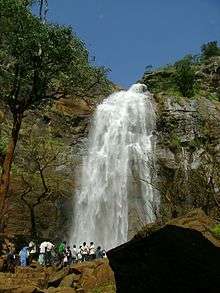
The hills are known for medicinal herbs and plants that grow in abundance on their slopes. The Arapaleswarar Temple, the Horticulture Farm, the herbal farm, Agaya Gangai waterfalls, boat house, Peryaswamy Temple, Ettukai Amman Temple, Pineapple farms, View Point, and the Telescope House are the places to visit for the interested tourist. Attukalkilangu soup and raw was sold in this hills. The Valvil Ori festival is organised there every year during the month of August.[9]
The Arapaleeswarar temple is believed to have a secret path to the Shiva temple in Rasipuram. This Shiva temple is said to have been built by Valvil Ori Vettuva king in the 1st or 2nd century AD when he ruled this area. "Arappaleeswara Sathakam" is the poem which praises the Lord Arappaleeswarar.
Jedarpalayam Dam
Jedarpalayam Dam is located in Kabilarmalai Panchayat Union of Namakkal District. It is located about 36 km from Namakkal. The dam is constructed across the River Cauvery. This dam is having a water storage area for boating.[9]
Transport
Transport is the major field of work in Namakkal. A large number of bulk carriers and lorries run through all over India from Namakkal. Many lorry (truck) body building workshops are located in Namakkal. Egg production in this district is largely facilitited by the lorry transport. It is the main centre for linking other districts via bus routes, to the North (Salem, Villupuram, Dharmapuri, Krishnagiri and Bangalore), East (Tiruchirapalli, Thanjavur, Thiruvarur and Nagapattinam), South (Karur, Dindugal, Madurai, Tiunelveli and Kanyakumari) and the West (Erode, Coimbatore, Tirupur and Nilgiris). The train route between Karur and Salem Junction saves fuel and time for transportation of goods.
Notable people
Natarajan Chandrasekaran, who hails from Mohanur, is the chairman and managing director of Tata Consultancy Services.
Venkatarama Ramalingam Pillai, the famous modern Tamil poet, a Gandhian independence fighter and a Padma Bhushan awardee, was also born in Mohanur.
Perumal Murugan, the famous Indian author, scholar and literary chronicler who writes novels in Tamil.
Notes
- Veterinary College and Research Institute, Namakkal (a constituent unit of Tamil Nadu Veterinary and Animal Sciences University) is located in Mohanur Taluk. It also has an Animal Feed Analysis and Quality Assurance Laboratory (AFAQAL).
- All the Arts and Science colleges in the district are affiliated to Periyar University, Salem.
See also
References
- ↑ "www.tn.gov.in" (PDF). TN.gov.in. Retrieved 19 April 2017.
- ↑ "General Information of Namakkal District - Tamilnadu". SouthIndiaOnline.com. Retrieved 19 April 2017.
- 1 2 3 "Namakkal District, Govt of Tamil Nadu". TN.nic.in. Archived from the original on 28 September 2011. Retrieved 19 April 2017.
- 1 2 "Statistical Handbook of Namakkal District 2016-17". namakkal.nic.in.
- 1 2 "Census Info 2011 Final population totals". Office of The Registrar General and Census Commissioner, Ministry of Home Affairs, Government of India. 2013. Retrieved 26 January 2014.
- ↑ "Census Info 2011 Final population totals - Namakkal district". Office of The Registrar General and Census Commissioner, Ministry of Home Affairs, Government of India. 2013. Retrieved 26 January 2014.
- 1 2 "Namakkal District Environment Profile, AIMS" (PDF). TNEnvis.nic.in. Retrieved 19 April 2017.
- ↑ http://www.tn.gov.in/deptst/animalhusbandry.pdf
- 1 2 3 4 ":::TTDC - Places:::". TamilNaduTourism.org. Retrieved 19 April 2017.
- ↑ http://www.aayakovil.org/
External links
| Wikimedia Commons has media related to Namakkal district. |
- Namakkal District website
- Namakkal District Water Supply Status (Tamilnadu Water Supply and Drainage Board)
| State symbols |
|
|---|---|
| Governance |
|
| Topics | |
| Districts |
|
| Major cities | |