Kongu Nadu
| Kongu Nadu | |
|---|---|
| Geographical area | |
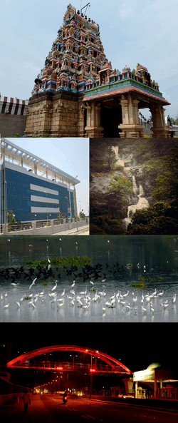 Coimbatore, largest metropolitan city in the region. | |
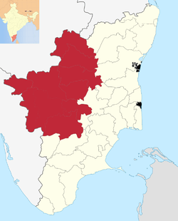 Kongu Nadu region within Tamil Nadu | |
| Coordinates: 11°1′48.925″N 77°2′21.544″E / 11.03025694°N 77.03931778°E | |
| Country |
|
| Region | South india |
| Government | |
| • Body | Government of Tamil Nadu |
| Area | |
| • Total | 45,493 km2 (17,565 sq mi) |
| Population (2011)[1] | |
| • Total | 2,07,43,812 |
| • Density | 607/km2 (1,570/sq mi) |
| Languages Kongu Tamil | |
| • Official | Tamil, English |
| • Others | Kongu Tamil |
| Time zone | UTC+5:30 (IST) |
| PIN | 635-642xxx |
| Vehicle registration | TN 27 to 42, TN 47, TN 52, TN 54, TN 56, TN 66, TN 77-78, TN 88, TN 86, TN 94, TN 99 |
| Largest city | Coimbatore |
| Literacy | 75.55% |
| Civic agency | Government of Tamil Nadu |
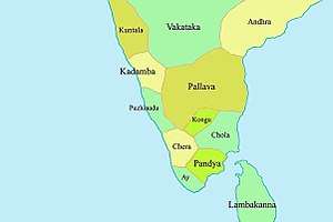
Kongu Nadu is a region and aspirant state of India comprising the western part of the Tamil Nadu. In the ancient Tamilakam, it was the seat of the Chera kings, bounded on the east by Tondai Nadu, on the south-east by Chola Nadu and on the south by Pandya Nadu regions.[2]
The region was ruled by the Cheras during Sangam period between c. 1st and the 4th centuries CE and it served as the eastern entrance to the Palakkad Gap, the principal trade route between the west coast and Tamil Nadu. The Kosar people mentioned in the second century CE Tamil epic Silappathikaram and other poems in Sangam literature is associated with the Coimbatore region. The region was located along an ancient Roman trade route that extended from Muziris to Arikamedu.The medieval Cholas conquered the region in the 10th century CE. It came under the rule of the Vijayanagara Empire by the 15th century. After the Vijayanagara Empire fell in the 17th century, the Madurai Nayaks, who were the military governors of the Vijayanagara Empire established their state as an independent kingdom. In the latter part of the 18th century, the region came under the Kingdom of Mysore, following a series of wars with the Madurai Nayak dynasty. After the defeat of Tipu Sultan in the Anglo-Mysore Wars, the British East India Company annexed Kongunadu to the Madras Presidency in 1799. The region was hard hit during the Great Famine of 1876–78 resulting in nearly 200,000 famine related fatalities. The first three decades of the 20th century saw nearly 20,000 plague-related deaths and acute water shortage.[3] The region played a significant role in the Indian independence movement.
Etymology
Kongu Nadu is believed to have come from "Kongadesam", "Konga" a variant of the term "Ganga", meaning "land of the Gangas".[4] Kongu may also mean nectar of flowers.[5]
History
Kongu Nadu was one of the earliest territorial divisions and home of the ancient Tamilians. The river Kaveri flows in southeastern direction through the region.[6] Archaeological data from Kodumanal, a village on the banks of the Noyyal River, suggests the beginning of civilization around 4th century BCE.[7] Kodumanal was situated on the ancient trade route between across the Palghat gap in the Western Ghats and yielded remains belonging to the Sangam age.[8][9] Tamil-Brahmi writings were found on coins, seals and rings obtained from Amaravathi river bed near Karur, the erstwhile capital of the Cheras.[10][11] A musical inscription in Tamil Brahimi was found in a cave in Arachalur, dating from the 4th Century CE and Iravatham Mahadevan writes that these are syllables used in dance.[12][13]
The region was ruled by the Cheras during Sangam period between c. 1st and the 4th centuries CE. The western part of the region was under the Cheras and the eastern regions were ruled by Pandyas. The medieval Cholas conquered most of the region in 10th century CE. After brief period under the Hoysalas and the delhi sultanate, the region was captured by the Vijayanagara Empire in the 15th century. In the 1550s, Madurai Nayaks, who were the military governors of the Vijayanagara Empire, took control of the region. After the Vijayanagara Empire fell in the 17th century, the Nayaks established their state as an independent kingdom and they introduced the Palayakkarar system.[14] In the latter part of the 18th century, the region came under the Kingdom of Mysore, following a series of wars with the Madurai Nayak dynasty. After the defeat of Tipu Sultan in the Anglo-Mysore Wars, the British East India Company annexed the region to the Madras Presidency in 1799. The region played a prominent role in the Second Poligar War (1801), when it was the area of operations of Dheeran Chinnamalai.[15]
Geography
Kongunadu comprises the modern day districts of Coimbatore district, Nilgiris district, Tirupur district, Erode district, Namakkal district, Karur district, Salem district, Dharmapuri district, Krishnagiri district and some parts of Dindigul district in the South Indian state of Tamil Nadu and also parts of South-western India including parts of Palakkad District in the Kerala state and parts of Chamarajanagar District in Karnataka state.[16] The Western Ghats mountain range passes through the region with major rives Kaveri, Bhavani, Amravati and Noyyal flowing through the region.[17] Palghat Gap, a mountain pass connects the neighbouring state of Kerala to the region.[18]
The table below lists geographic and demographic parameters for districts that constitute the 'Kongu region' of Tamil Nadu.[19]
| S.No. | Districts | Headquarters | Established | Area (km²) | Population (2011 Census) | Population density (/km²) | Taluks | Map |
|---|---|---|---|---|---|---|---|---|
| 1 | Coimbatore | Coimbatore | 1 November 1956 | 4,723[20] | 3,458,045[21] | 732 | 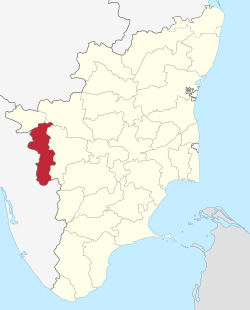 | |
| 2 | Dharmapuri | Dharmapuri | 2 October 1965 | 4,497.77 | 1,506,843[23] | 335 | 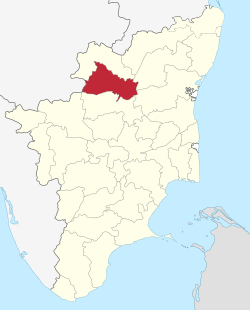 | |
| 3 | Erode | Erode | 31 August 1979 | 5760 | 2,251,744[24] | 394 | 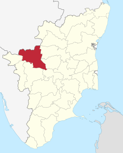 | |
| 5 | Karur | Karur | 30 September 1995 | 2,895.57 | 1,064,493[25] | 368 |  | |
| 6 | Krishnagiri | Krishnagiri | 9 February 2004 | 5,143 | 1,879,809[26] | 366 |  | |
| 7 | Namakkal | Namakkal | 1 January 1997 | 3363 | 1,726,601[27] | 513 | 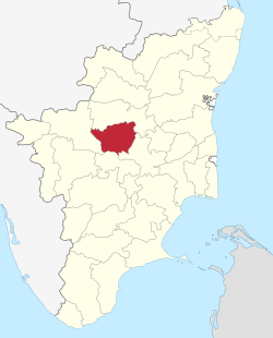 | |
| 8 | The Nilgiris | Ooty | 1 November 1956 | 2,452.5 | 735,394[28] | 300 | 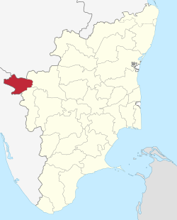 | |
| 9 | Salem | Salem | 1 November 1956 | 5,205 | 3,482,056[29] | 669 | 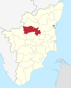 | |
| 10 | Tiruppur | Tiruppur | 22 February 2009 | 5,186.34 | 2,479,052[30] | 478 | 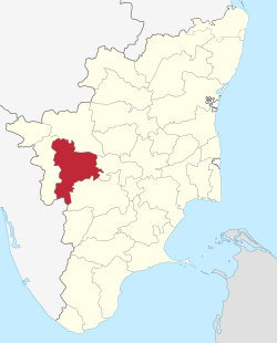 | |
| Total | 45,493 | 2,07,43,812 |
Language
Kongu Tamil is the dialect of Tamil language that is spoken in Kongu Nadu, which is the western region of Tamil Nadu. It is originally known as "Kangee"`[31] or "Kongalam"[32] or "Kongappechu".
Economy
Kongu Nadu had a flourishing economy from ancient times and had trade contacts with foreign nations. Kodumanal was a 2,500-year-old industrial colony discovered by archaeologists.[33][34] The region was located along an ancient Roman trade route that extended from Muziris to Arikamedu.[35][36] A Chola highway called Rajakesari Peruvazhi ran through the region.[37][38]
Kongu Nadu is amongst the most industrialised regions in the country. Agriculture and textile industries contribute majorly to the economy of the region.[39] It is one of the major producers of textiles including cotton,[40] apparels and knit wear,[41] and hosieries, agricultural and allied products including milk, poultry,[42] turmeric, sugar-cane, rice, white silk, coconut and plantain, industrial products including paper, auto parts,[43] water pumps,[44] wet grinders, [45] jewellery,[46] aluminium and steel and IT services[47][48] in Tamil Nadu.[49] Kovai Cora cotton sarees, Coimbatore Wet Grinders, Salem silk sarees, Bhavani Jamakkalam, Toda Embroidery and Nilgiri tea are recognized Geographical Indications from the region.[50][51]
Cuisine
Kongu Nadu cuisine is predominantly south Indian with rice as its base and a collection of exotic recipes being created by the people residing in the Kongu region. Food is served over a banana leaf.[52] Eating on a banana leaf is an old custom and imparts a unique flavor to the food and is considered healthy.[53] Idly, dosa, paniyaram and appam are popular dishes.[54][55][56][57] Kongu Nadu cuisine does not involve marination of any raw material and as a result the food has a different taste and unique texture. Turmeric is added into curries which gives the product a deep yellow colour and an aromatic substance. Arisi Paruppu Sadam,santhava made from a mixture of dal and rice is a recipe that existed from fourth century CE and unique to the area.[58] Kaalaan is a popular dish prepared by simmering deep fried mushrooms (usually chopped mushroom) in a spicy broth, until it reaches a porridge like consistency and served sprinkled with chopped onions and coriander leaves.[59][60] The traditional Kongu people were mostly vegetarians for religious reason.[61] Oppitu is a type of sweet made with the basic ingredients rice, sundal paruppu, palm jaggery, cardamom and ghee.[62]
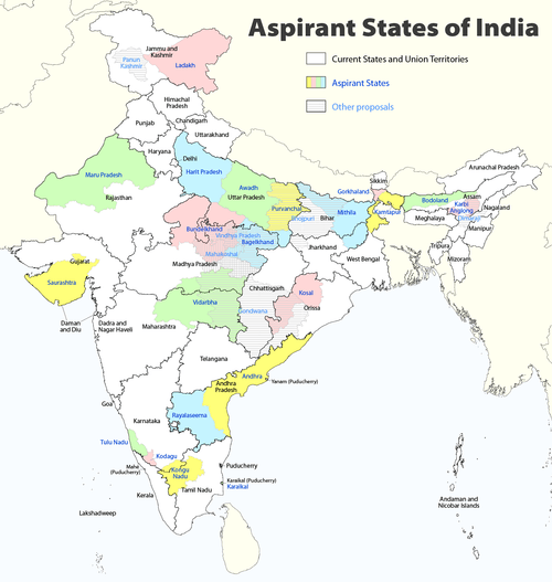
Separate statehood
There have been numerous claims that Kongu Nadu region has often been ignored by successive governments in spite of being the largest contributor to the state's economy. The entire region comprising 10 districts accounts for more than 40 percent of the revenue. There are demands for the creation of separate state of Kongu Nadu, comprising the regions of western districts of Tamil Nadu. A number of political outfits namely Kongunadu Makkal Desia Katchi, Kongunadu Munnetra Kazhagam, Kongu Vellala Goundergal Peravai, Tamil Nadu Kongu Ilaignar Peravai, Kongu Desa Makkal Katchi are active in the region claiming to fight for the rights of the region.[63][64][65][66]
References
- ↑ "Census of India". Government of India. 2001. Archived from the original on 12 May 2008. Retrieved 26 October 2010.
- ↑ Thurston, Edgar; Rangachari, K. (1987). Castes and Tribes of Southern India. Asian Educational Services. pp. 156–. ISBN 978-81-206-0288-5.
- ↑ "The perils of the past". The Hindu. 28 May 2005. Retrieved 26 February 2018.
- ↑ Menon, P. Shungoonny (1 January 1998). History of Travancore from the Earliest Times. Asian Educational Services. pp. 33–. ISBN 978-81-206-0169-7.
- ↑ Ramamurthy, V. (1986). History of Kongu: Volume 1. p. 19.
- ↑ Ramaswamy, Vijaya (2017). Historical Dictionary of the Tamils. Rowman & Littlefield. p. 217. ISBN 978-1-5381-0686-0.
- ↑ Singh, Upinder (2009). A History of Ancient and Early Medieval India: From the Stone Age to the 12th Century. Addison Wesley. ISBN 978-81-317-1120-0.
- ↑ Sasisekaran, B.; Raghunatha Rao, B. (1999). "I 999" (PDF). Indian Journal of History of Science. 34 (4). Archived from the original (PDF) on 20 January 2010. Retrieved 11 December 2010.
- ↑ Rajan, K.; Athiyaman, N. (2004). "Traditional Gemstone Cutting Technology of Kongu Region in Tamil Nadu" (PDF). Indian Journal of History of Science. 39 (4): 385–414. Archived from the original (PDF) on 21 July 2011.
- ↑ "Roman Karur". Tamilartsacademy.com. Archived from the original on 7 May 2012. Retrieved 3 May 2012.
- ↑ Rami Reddy, V.; Chandrasekhar Reddy, B.K. (2004). "Morphometric Status of Human Skeletal Remains From Kodumanal, Periyar District, Tamil Nadu" (PDF). Anthropologist. 6 (4): 104–112.
- ↑ Rao, Subha J. (1 October 2005). "Writing on the rock". The Hindu. Chennai, India. Retrieved 1 June 2016.
- ↑ Parthasarathy, Indira (2 August 2003). "Records and revelations". The Hindu. Archived from the original on 31 July 2010. Retrieved 1 June 2016.
- ↑ "The land called Kongunad". The Hindu. 19 November 2005. Retrieved 9 June 2010.
- ↑ "Remembering Dheeran Chinnamalai". The Hindu. 3 August 2007. Retrieved 15 January 2011.
- ↑ Mohan, Rohini (9 May 2016). "No 'Marriage' of Ideologies: Kongu Parties Find Raison D'être in Their Differences With Dalits". The New Indian Express. Retrieved 1 June 2016.
- ↑ "The Peninsula". Asia-Pacific Mountain Network. Archived from the original on 12 August 2007. Retrieved 19 March 2007.
- ↑ "Britannica Encyclopedia". Retrieved 8 March 2015.
- ↑ "Districts of Tamil Nadu". Government of Tamil Nadu.
- ↑ "Coimbatore District Administration - Statistical HandBook". www.coimbatore.nic.in. Retrieved 2018-01-27.
- ↑ "Census Info 2011 Final population totals - Coimbatore district". Office of The Registrar General and Census Commissioner, Ministry of Home Affairs, Government of India. 2013. Retrieved 26 January 2014.
- ↑ "District Map of Coimbatore". Coimbatore District administration. 2009. Retrieved 24 January 2014.
- ↑ "Census Info 2011 Final population totals - Dharmapuri district". Office of The Registrar General and Census Commissioner, Ministry of Home Affairs, Government of India. 2013. Retrieved 26 January 2014.
- ↑ "Census Info 2011 Final population totals - Erode district". Office of The Registrar General and Census Commissioner, Ministry of Home Affairs, Government of India. 2013. Retrieved 26 January 2014.
- ↑ "Census Info 2011 Final population totals - Karur district". Office of The Registrar General and Census Commissioner, Ministry of Home Affairs, Government of India. 2013. Retrieved 26 January 2014.
- ↑ "Census Info 2011 Final population totals - Krishnagiri district". Office of The Registrar General and Census Commissioner, Ministry of Home Affairs, Government of India. 2013. Archived from the original on 24 September 2015. Retrieved 26 January 2014.
- ↑ "Census Info 2011 Final population totals - Namakkal district". Office of The Registrar General and Census Commissioner, Ministry of Home Affairs, Government of India. 2013. Retrieved 26 January 2014.
- ↑ "Census Info 2011 Final population totals - Nilgiris district". Office of The Registrar General and Census Commissioner, Ministry of Home Affairs, Government of India. 2013. Retrieved 26 January 2014.
- ↑ "Census Info 2011 Final population totals - Salem district". Office of The Registrar General and Census Commissioner, Ministry of Home Affairs, Government of India. 2013. Retrieved 26 January 2014.
- ↑ "Census Info 2011 Final population totals - Tiruppur district". Office of The Registrar General and Census Commissioner, Ministry of Home Affairs, Government of India. 2013. Retrieved 26 January 2014.
- ↑ Severine Silva. Toponomy of Canara. p. 34.
In the southern part of Mysore the Tamil language is at this day named the Kangee, from being best known to them as the language of the people of Kangiam
- ↑ F. Poezold, William Simpson (1809). Tamil̲umaiṅakilēcumāyirukakir̲a akarāti. Oxford University.
- ↑ "A 2,500-year-old industrial estate". Rediff. Retrieved 1 June 2016.
- ↑ Subramanian, T. S (28 January 2007). "Roman connection in Tamil Nadu". The Hindu. Retrieved 28 October 2011.
- ↑ "Kovai's Roman connection". The Hindu. 8 January 2009. Retrieved 9 June 2010.
- ↑ "On the Roman Trail". The Hindu. 21 January 2008. Retrieved 9 June 2010.
- ↑ Vanavarayar, Shankar (21 June 2010). "Scripting history". The Hindu. Retrieved 9 May 2011.
- ↑ M, Soundariya Preetha (30 June 2007). "Tale of an ancient road". The Hindu. Retrieved 9 May 2011.
- ↑ "When the Gods came down". The Hindu Business Line. 8 May 2014. Retrieved 7 March 2016.
- ↑ "State wise number of cotton mills" (PDF). Confederation of Textile Industry. Retrieved 23 January 2016.
- ↑ Chakrapani, Saranya (20 November 2014). "Coimbatore: Rise of the self-made city". India Today. Retrieved 7 March 2016.
- ↑ "Tamil Nadu Poultry Industry Seeks Export Concessions". Financial Express. Retrieved 28 March 2015.
- ↑ Yegya Narayanan, R. "Coimbatore's small auto component makers find the going tough". Business Line.
- ↑ "Poor sales hit pump unit owners, workers". Times of India. 26 May 2015. Retrieved 28 June 2015.
- ↑ "Poll code set to hit wet grinders business". Live Mint. 6 August 2015. Retrieved 20 September 2015.
- ↑ "India's Gems and Jewellery Market is Glittering". Resource Investor. Retrieved 30 August 2011.
- ↑ Sujatha, S (13 January 2010). "Coimbatore gears up for IT revolution, Tidel park to be ready by April end". The Economic Times. Retrieved 7 March 2016.
- ↑ "Coimbatore: IT sector on the fast track". India Today. 22 April 2011. Retrieved 30 August 2011.
- ↑ "Indian Government press release". Press Information Bureau, Government of India. 31 October 2011. Retrieved 31 January 2013.
- ↑ "Common facility for wet grinders". The Hindu. 5 August 2007. Retrieved 20 September 2009.
- ↑ "31 ethnic Indian products given GI protection". Financial Express. 4 April 2008. Retrieved 26 January 2016.
- ↑ "Serving on a banana leaf". ISCKON. Archived from the original on 14 January 2016. Retrieved 1 January 2016.
- ↑ "The Benefits Of Eating Food On Banana Leaves". India Times. 9 March 2015.
- ↑ "Snack Street combines taste of street food with hygiene of restaurant". The Hindu. 19 July 2013. Retrieved 4 March 2016.
- ↑ Achaya, K.T. (1 November 2003). The story of our food. Universities Press. p. 80. ISBN 978-81-7371-293-7.
- ↑ Balasubramanian, D (21 October 2014). "Changes in the Indian menu over the ages". The Hindu.
- ↑ "Kovakkai, Kongunadu and Quizzing". The Hindu. 3 February 2011. Retrieved 1 October 2015.
- ↑ Nagarajan, Rema (26 March 2011). "Taste some cuisine from Kongunadu". Times of India. Retrieved 14 May 2016.
- ↑ Kannadasan, Akila (2 November 2012). "A rainy day". The Hindu. Retrieved 7 March 2016.
- ↑ Nath, Parthasarathy (27 May 2013). "A taste of tradition". The Hindu. Retrieved 1 October 2015.
- ↑ Francis Hamilton; East India Company (1807). A journey from Madras through the countries of Mysore, Canara, and Malabar. T. Cadell and W. Davies. pp. 330–.
- ↑ "Kongu Food Info by Times : Kongunadu Cuisine". Times Of India. 26 March 2011.
- ↑ "India may have 50 states if new demands met". Times of India. 4 August 2013. Retrieved 1 June 2016.
- ↑ "Region's 'neglect' by governments prompted party formation". Chennai Online. Archived from the original on 5 March 2016. Retrieved 1 June 2016.
- ↑ "Beginning with message of conservation". The Hindu. Chennai, India. 10 April 2009. Retrieved 1 June 2016.
- ↑ "KMP to work for progressive Western Tamil Nadu". The Hindu. Chennai, India. 29 April 2009. Retrieved 1 June 2016.
| State symbols |
|
|---|---|
| Governance |
|
| Topics | |
| Districts |
|
| Major cities | |
| Proposed states |
|  |
|---|---|---|
| Proposed territories |
| |