Matheran
| Matheran | |
|---|---|
| Hill station | |
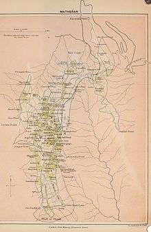
 Detailed map of Matheran | |
 Matheran Location in Maharashtra, India | |
| Coordinates: 18°59′12″N 73°16′04″E / 18.9866°N 73.2679°ECoordinates: 18°59′12″N 73°16′04″E / 18.9866°N 73.2679°E | |
| Country | India |
| State | Maharashtra |
| District | Raigad |
| Government | |
| • Type | Municipal Council |
| • Body | Matheran Hill Station Municipal Council |
| Area | |
| • Total | 7 km2 (3 sq mi) |
| Elevation | 800 m (2,600 ft) |
| Population (2001) | |
| • Total | 5,139 |
| • Density | 730/km2 (1,900/sq mi) |
| Languages | |
| • Official | Marathi |
| • Spoken | Marathi |
| Time zone | UTC+5:30 (IST) |
| PIN | 410102 |
| Telephone code | 02148 |
| Vehicle registration | MH-46 |
| Nearest city | Karjat |
Matheran is a hill station and a municipal council in Karjat Tahsilin the Raigad district in the Indian state of Maharashtra. It is one of the smallest hill station in India, it is located on the Western Ghats range at an elevation of around 800 m (2,625 feet) above sea level. It is about 90 km from Mumbai, and 120 km from Pune. Matheran's proximity to many metropolitan cities makes it a popular weekend getaway for urban residents. Matheran, which means "forest on the forehead" (of the mountains) is an eco-sensitive region, declared by the Ministry of Environment, Forest and Climate Change, Government of India. It is Asia's only automobile-free hill station.[1][2]
There are around 38 designated look-out "points" (viewpoints) in Matheran, including the Panorama Point that provides a 360-degree view of the surrounding area and also the Neral town. From this point, the view of sunset and sunrise is dramatic. The Louisa Point offers crystal clear view of the Prabal Fort. The other points are the One Tree Hill Point, Heart Point, Monkey Point, Porcupine Point, Rambagh Point, and more. To stay there, there are plenty of hotels. There are many Parsi bungalows. Beautiful old British-style architecture is preserved in Matheran.[3] The roads are not metalled and are made of red laterite earth.
Soil and rocks
Geographically the rock types are being solely composed of Deccan trap with inter trappeans of Cretaceous, Eoceuerage and laterites of still younger age. The rock is basalt, which has given rise to secondary alteration known as laterite. The laterite predominates in the hills and almost cover the hill tops, therefore in the hill region the hard exposed surfaces of the laterite shows red gravelly earth. The soil has a vermicular or pisolitic structure and contains much water. Over almost the whole hill-top there is little soil cover. The topmost layer of rock is a soft porous iron-clay, through which, by the beginning of the hot season, the whole rainfall has drained.
History
Matheran was identified by Hugh Poyntz Malet, the then district collector of Thane district in May 1850. Lord Elphinstone, the then Governor of Bombay laid the foundations of the development as a future hill station. The British developed Matheran as a popular resort to beat the summer heat in the region. Matheran is the birthplace of famous freedom fighter Veer Bhai Kotwal. He was born on 1 December 1912 in a Barber family. The state government has built a monument in his memory. The Matheran Hill Railway was built in 1907 by Sir Adamjee Peerbhoy and covers a distance of 20 km (12 mi), over large swathes of forest territory.[4] The Matheran hill railway, also known as Matheran Light Railway (MLR), was inspected by UNESCO world heritage site officials but failed to make it to the list as a World Heritage Site. India's other Hill Railways like the Darjeeling Railway, the Kangra Valley Railway, Nilgiri Mountain Railway are already on the list.[5]
Forest and vegetation
The forest type of Matheran is semi evergreen forests.[6] The trees are evergreen, making the plateau forests very dense and even congested in places. The luxuriant growth represents the climatic climax of the forest. The laterite, porous soil along with very heavy rainfall mixed with dense fog for 4-5 has resulted in unique flora rich in diversity on the plateau. The forests show vegetation in top, middle and ground storey. The trees form a cover over large variety of shade loving herbs, climbers, ferns and mosses. The forests of Matheran have attracted many botanists who have studied the flora of Matheran: Smyth J.Y.(1871), Birdwood H.M. (1886) and (1896), Cooke T. (1887–1901), Woodrow G.M. (1897-1901), Irani N.A.(1962), Satyanarayann & Mudliar (1959), Vartak, V.D.(1966), Kothari & Moorthy (1993).[7] A good collection of the dried plants is deposited in Blatter Herbarium, St. Xavier's College, Bombay, Mumbai. Matheran has a huge number of medicinal plants and herbs. Matheran was declared an Eco-Sensitive zone (ESZ) by the Union Environment Ministry on 4 February 2003[8] and can be called a health sanatorium in itself.The declaration as ESZ has led to the stoppage of developmental activities and construction of hazardous industries.[9]
Conservation
The vegetation of the area depends on the type and depth of the soil. Due to poor soil depth, the vegetation on the edges of the plateaus is poor. Due to heavy rainfall, dissected hilly terrain and excessive leaching of the soil, the exposed areas become less fertile and become less moisture retentive, resulting in shallow rooted vegetation. It is required to plant trees to protect the soil cover from losing its valuable humidity and fertility. The winds are very strong and blow from west or southwest during monsoon and also dry winds blow during the three months from January to March. These winds tend to shear and bend the plant parts and absorb the moisture from the plants.
Wildlife
The town also has a large monkey population, including bonnet macaques and Hanuman langurs. The nearby Lake Charlotte is the main source of Matheran's drinking water. Inside the forest animals like leopard, barking deer, Malabar giant squirrel, fox, wild boar, mongoose are found.
Demographics
As of 2001 India census,[10] Matheran had a population of 5139. Males constitute 58% of the population and females 42%. Matheran has an average literacy rate of 71%: male literacy is 75%, and female literacy is 66%. In Matheran, 11% of the population is under 6 years of age.Languages spoken include Marathi, Hindi, and English.
Geography
Matheran is located at 18°59′N 73°16′E / 18.98°N 73.27°E.[11] It has an average elevation of 800 metres (2,625 feet).Matheran lies in an elevated region, enjoys a cooler and less humid climate which makes it popular during the summer months. Temperatures range from 32 °C (90 °F) to 16 °C (61 °F).
| Climate data for Matheran | |||||||||||||
|---|---|---|---|---|---|---|---|---|---|---|---|---|---|
| Month | Jan | Feb | Mar | Apr | May | Jun | Jul | Aug | Sep | Oct | Nov | Dec | Year |
| Average high °C (°F) | 28 (82) |
30 (86) |
31 (88) |
32 (90) |
33 (91) |
32 (90) |
30 (86) |
30 (86) |
29 (84) |
33 (91) |
31 (88) |
29 (84) |
31 (87) |
| Average low °C (°F) | 13 (55) |
14 (57) |
16 (61) |
19 (66) |
22 (72) |
22 (72) |
21 (70) |
21 (70) |
20 (68) |
19 (66) |
17 (63) |
13 (55) |
18 (65) |
| Average precipitation mm (inches) | 2.0 (0.079) |
1.5 (0.059) |
2.3 (0.091) |
4.1 (0.161) |
25.1 (0.988) |
773.9 (30.469) |
2,035.6 (80.142) |
1,461 (57.52) |
658.6 (25.929) |
168.1 (6.618) |
31.5 (1.24) |
3.8 (0.15) |
5,167.5 (203.446) |
| Source: Government of Maharashtra | |||||||||||||
Transport
Matheran is well connected to Mumbai (100 km) & Pune (120 km) by rail and road, while Neral is the nearest rail station. The Matheran Light Railway (MLR) offers limited seats for each trip. You can even hire a local van to travel till the Dhindi Point. From Dhindi Point you have to walk for about 30 minutes along the railway track to reach Matheran. The only form of automobile allowed in Matheran is an ambulance operated by the Municipality. No private automobiles are allowed in Matheran. Within Matheran transport facilities available are horses and hand-pulled rickshaws. People who cannot walk are suggested to contact the Neral railway officials to check whether the toy train is operating or not.The Toy train was shutdown for most part 2016-2017. But it is now operational since January 26th 2018 and was e-inaugurated by the Maharashtra CM Devendra Fadnavis. Only 1 Ride from Neral to Matheran and it leaves Neral at 6:40 AM and reaches Matheran around 9:40 AM. Thereafter it operates shuttle rides between Aman Lodge and Matheran Station on hourly basis and at 3:30 PM it returns back to Neral from Matheran. It takes 2 hours to Travel for return journey. In Matheran you will get horses as a mode of transport. Because of landslides during the rain fall, the toy train services may be terminated temporarily. The nearest airport is Chhatrapati Shivaji International Airport, Mumbai that is located around 100 km away from Matheran. Matheran has a narrow gauge railway station in the town center. The old Matheran Hill Railway offers several daily trains to Neral. The toy train connected to the mainline rail route at Neral Junction. Neral Junction is well connected by local trains from CST along the CST-Karjat route. The train covers a distance of 12 miles in an hour thereby allowing the passengers ample time to soak in the beauty of the surroundings.The IRCTC conducts tour packages for the railway trip[4] Any Pune bound train from CST(Mumbai) reaches Neral in approximately two hours.to get there you have to take train from Mumbai to Neral junction;from Neral to Matheran by narrow gauge trains that depart at 8:40 AM, 11:00 AM, 5:00 PM. Trekkers prefer to travel by State transport bus from Panvel to Dodhani ( 15 km). From Dodhani it is an hours trek to the sun set point of Matheran. This trek is very safe and easy to walk. Many trekkers prefer it during monsoon.This path passes through forest area, with lots of streams and lush green trees.
Places to Explore

There are altogether 28 points, two lakes, two parks, four major worship places[12] and a race course to visit in Matheran. It takes about 2–3 days by foot for a complete tour of all the points. Important points are Alexander Pt., Rambag Pt, Little Chowk Pt, Big Chowk Pt, One Tree Hill Pt, Belvedere Pt, Olympia Race Course (established in 1892-93 by Sir Dhunjibhoy Bomanji)[13], Lords Pt, Charlotte Lake, Pisharnath Mahadev Mandir, Celia Pt (a water fall mouth), Echo Pt., Porcupine Pt (Sun Set Pt), Panorama Point (Sun Rise Pt), Khandala Pt, Madhavji Garden & Point, Matheran Railway Station, Louisa Point, Mayra Point, Pisarnath Temple, Matheran Shiv Mandir.View points like monkey and echo are famous for steep cliffs, deep ravines. One day trekking to vikatgad is an adventurous experience along the cliffs and deep ravines.
List of trees growing in Matheran
| Sr. No. | Scientific names of the species | Common names |
|---|---|---|
| 1 | Albizzia chinensis (Osb.) Merr. | Udal, Kajav |
| 2 | Actinodaphne angustifolia Nees. | Pisa |
| 3 | Aglaia lawii (Wight.) Sald. | |
| 4 | Alseodaphne semicarpifolia Nees. | Sugran |
| 5 | Alstonia scholaris (L.) R.Br. | Saitan, Satvin |
| 6 | Aporosa lindleyana (Wight) Baill. | Ukveti |
| 7 | Artocarpus lakoocha Roxb. | Kemshi |
| 8 | Atlantia racemosa Wight. & Arn. | Makad limbu |
| 9 | Bambusa arundinacea (Retz.) Roxb | Kalak |
| 10 | Bauhinia foveolata Dalz. | Chambel. |
Gallery
 The pathways
 The trek route through one tree hill
 Tourist at Charlotte lake
 The forest
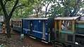 The Toy train
 The Veer Kotwal Garden
 Sunset point in rains
 Steep hills around the Matheran
References
- ↑ Seminar. R. Thapar. 2003. Retrieved 8 July 2013.
- ↑ Shyam Kishor Agarwal (1991). Automobile pollution: concerns, priorities, and challenges. APH Publishing. p. 91. ISBN 978-81-7024-414-1. Retrieved 8 July 2013.
- ↑ http://raigad.nic .in/DG/1964/places_Matheran.html
- 1 2 "Neral-Matheran Toy Train Tour". www.irctcTourism.com. Retrieved 30 October 2017.
- ↑ Rangnekar, Prashant (3 August 2010). "Neral-Matheran misses world heritage site target". The Indian Express. Retrieved 9 September 2012.
- ↑ "Forest Types - National Remote Sensing Centre". NRSC.gov.in. Retrieved 30 October 2017.
- ↑ Kothari, M. J.; Moorthy, S. (30 October 1993). "Flora of Raigad District, Maharashtra State". Botanical Survey of India. Retrieved 30 October 2017 – via Google Books.
- ↑ https://mmrda.maharashtra.gov.in/documents/10180/760410/Notification+MoEF+Matheran+Eco-Sensitive+Zone.pdf/ff47de8c-59dd-498e-81f8-a82133578839?version=1.0
- ↑ http://mahenvis.nic.in/pdf/Newsletter/nletter_Matheran%20-Ecologically%20Sensitive%20Hill%20Station%20of%20Maharashtra.pdf
- ↑ "Census of India 2001: Data from the 2001 Census, including cities, villages and towns (Provisional)". Census Commission of India. Archived from the original on 2004-06-16. Retrieved 1 November 2008.
- ↑ "Maps, Weather, and Airports for Matheran, India". www.FallingRain.com. Retrieved 30 October 2017.
- ↑ "Matheran Tourism > Travel Guide, Best Attractions, Tours & Packages". www.Holidify.com. Retrieved 30 October 2017.
- ↑ Keith., Kennedy, Dane (1996). The magic mountains : hill stations and the British raj. Berkeley: University of California Press. p. 206. ISBN 0585069875. OCLC 42922469.
External links
| Wikimedia Commons has media related to Matheran. |

- Matheran Hill Railway Schedule at India Rail Info
- Neral to Matheran Light Train Timetable
- Fresh attempts to get heritage status for Matheran Light Rail - Indian Express (14 January 2013)
- Matheran A Practical Guide Written By Shailendra Patil and Published by Rainbow Adventures.