Madurai district
| Madurai District | |
|---|---|
| District | |
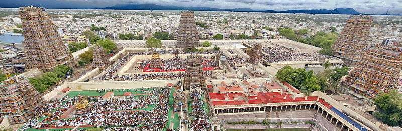 Pilgrimage at Meenakshi Amman Temple, Madurai | |
 Location in Tamil Nadu, India | |
| Coordinates: 09°50′N 077°50′E / 9.833°N 77.833°ECoordinates: 09°50′N 077°50′E / 9.833°N 77.833°E[1] | |
| Country |
|
| State | Tamil Nadu |
| Municipal Corporations | Madurai |
| Headquarters | Madurai |
| Taluks |
Madurai North, Madurai South, Madurai East, Madurai West, Melur, Peraiyur, Tirumangalam, Thiruparankundram, Usilampatti, Vadipatti, Kalligudi |
| Government | |
| • District Collector | Natarajan, IAS[2] |
| • Commissioner of Police | Mahesh Kumar Aggarwal, IPS[3] |
| Area | |
| • Total | 3,741.73 km2 (1,444.69 sq mi) |
| Population (2011)[4] | |
| • Total | 3,038,252 |
| • Density | 823/km2 (2,130/sq mi) |
| Languages | |
| • Official | Tamil |
| Time zone | UTC+5:30 (IST) |
| PIN | 625001 |
| Telephone code | 0452 |
| Vehicle registration | TN-58, TN-59, TN-64[5] |
| Coastline | 0 kilometres (0 mi) |
| Largest city | Madurai |
| Sex ratio | ♂-50.5% / ♀-49.5% |
| Literacy | 81.5% |
| Lok Sabha constituency | 1 |
| Assembly constituency | 10 |
| Website |
www |
The Madurai district is the ninth largest in population of the 32 districts of the state of Tamil Nadu in southeastern India.[1] The city of Madurai serves as the district headquarters. It houses the world-famous Sri Meenakshi Sundareshwarar temple and is situated on the banks of the river Vaigai and the oldest Islamic mosque in Madurai The Kazimar Big Mosque situated in the banks of Kiruthumal river. Thiruparankundram is one of the major tourist place in the district. As of 2011, the district had a population of 3,038,252 with a sex-ratio of 990 females for every 1,000 males. Aside from the city of Madurai, the larger towns are Melur, vadipatti, Peraiyur, Thirumangalam and Usilampatti.[6] It is an important hub for various film shootings.
History
Madurai is called with various nicknames like Athens of the East, Thoonga Nagaram (City that never Sleeps), Naan maada koodal (City of Four junctions), Malligai Managar (City of Jasmine), Koodal Managar (City of Junction) Koil Nagar (Temple city) etc. The main kingdoms which ruled Madurai during various times are the Pandyas and the Nayaks.
Demographics
According to 2011 census, Madurai district had a population of 3,038,252[7] up from 2,578,201 in the 2001 census,[6] for a growth rate of 17.95%. It had a sex-ratio of 990 females for every 1,000 males, up from 978 in 2001,[6] and much above the national average of 929.[7] A total of 313,978 were under the age of six, constituting 162,517 males and 151,461 females. Scheduled Castes and Scheduled Tribes accounted for 13.46% and .37% of the population respectively. The average literacy of the district was 74.83%, compared to the national average of 72.99%.[7] The district had a total of 794,887 households. There were a total of 1,354,632 workers, comprising 81,352 cultivators, 287,731 main agricultural labourers, 39,753 in house hold industries, 765,066 other workers, 180,730 marginal workers, 11,367 marginal cultivators, 85,097 marginal agricultural labourers, 7,540 marginal workers in household industries and 76,726 other marginal workers.[8]
Divisions
Madurai district comprises 13 talukas and revenue blocks, same names same boundaries. Under the gram panchayat system rural administration or the district is done by panchayat villages and the taluka headquarters. The revenue blocks are further sub-divided by firkas. The last three taluks, Tiruparankundram, Madurai West and Madurai East, were created in February 2014.[9] The thirteen talukas/blocks are:[10][11]
- Thiruparankundram—7 firkas
- T.Kallupatti—3 firkas
- Tirumangalam—3 firkas
- Kalligudi
- Sedapatti
- Usilampatti
- Vadipatti
- Melur
- Madurai West
- Madurai East
- Kottampatti
- Alanganallur
- Chellampatti
2001 census

In the 2001 census, Madurai district had only seven talukas: Madurai North, Madurai South, Melur, Peraiyur, Thirumangalam, Vadipatti, and Usilampatti.[12]
Electoral divisions
| Assembly Constituency |
Political Party |
Elected Representative |
|---|---|---|
| Thirupparankundram | -- | Vacant |
| Usilampatti | AIADMK | Neethipathi |
| Madurai North | AIADMK | V. V. Rajan Chellappa |
| Melur | AIADMK | Periya Pullan |
| Madurai East | DMK | P. Moorthy |
| Madurai Central | DMK | P.T.R.P.Thiyagarajan |
| Sholavandan | AIADMK | K Manickam |
| Tirumangalam | AIADMK | R. B. Udhaya Kumar |
| Madurai South | AIADMK | S.S.Saravanan |
| Madurai West | AIADMK | K. Raju |
| Lok Sabha Constituency |
Political Party |
Elected Representative |
| Madurai | AIADMK | Gopalkrishnan R |
| Source: Indian Elections / Election Commission of India.[13][14] | ||
Geography
Climate
| Madurai | ||||||||||||||||||||||||||||||||||||||||||||||||||||||||||||
|---|---|---|---|---|---|---|---|---|---|---|---|---|---|---|---|---|---|---|---|---|---|---|---|---|---|---|---|---|---|---|---|---|---|---|---|---|---|---|---|---|---|---|---|---|---|---|---|---|---|---|---|---|---|---|---|---|---|---|---|---|
| Climate chart (explanation) | ||||||||||||||||||||||||||||||||||||||||||||||||||||||||||||
| ||||||||||||||||||||||||||||||||||||||||||||||||||||||||||||
| ||||||||||||||||||||||||||||||||||||||||||||||||||||||||||||
The climate is moderate with no extremes. There are three distinct periods of rainfall:
- advancing monsoon period and south west monsoon from June to September, with strong southwest winds;
- north east monsoon from October to December, with dominant north east winds;
- dry season from January to May.
Tourist attraction
- Madurai Meenakshiamman temple
- Gandhi Memorial Museum, Madurai (Erst while Rani Mangammal Palace)
- Thiruparankundram Dargah
- Thirumalai Nayakar Mahal
- Kazimar Periya Pallivasal
- Theppakulam, Vandiyur
- Goripalayam Mosque
- Madurai Maqbara
- Thiruvathavur Thirumarainathar Temple and Birth place of Manicka Vasakar
- Thirumohoor Kalamegaperumal Temple
- Alagar Koyil
- Thirupparankundram Murugan Temple
- 1000 kaal Mandapam (1000 pillar hall)
- Eco park
- Kuruvithurai Vallaba Perumal Temple
- Vaigai Dam (nearby)
- Anaipatti Anjaneyar Temple
- Kodaikanal (nearby)
- Suruli falls (nearby)[15]
- Kutladampatti falls
References
- 1 2 Madurai (Approved) at GEOnet Names Server, United States National Geospatial-Intelligence Agency
- ↑ Collector
- ↑ of Police
- ↑ "District Census 2011". Registrar General & Census Commissioner, India. 2011. Archived from the original on 5 May 2012. Retrieved 2011-09-30.
- ↑ "Registration Series Allotted to Regional Transport Offices" (PDF). Government of Tamil Nadu, State Transport Authority. Archived (PDF) from the original on 12 September 2012.
- 1 2 3 "Census of India 2001: Basic data Sheet: Madurai District, Tamil Nadu" (PDF). The Registrar General and Census Commissioner.
- 1 2 3 "Census Info 2011 Final population totals". Office of The Registrar General and Census Commissioner, Ministry of Home Affairs, Government of India. 2013. Retrieved 26 January 2014.
- ↑ "Census Info 2011 Final population totals - Krishnagiri district". Office of The Registrar General and Census Commissioner, Ministry of Home Affairs, Government of India. 2013. Retrieved 26 January 2014.
- ↑ Mariappan, Julie (12 February 2014). "23 new taluks created in Tamil Nadu". The Times of India. Archived from the original on 19 July 2014.
- ↑ "Map: Madurai District Blocks". Madurai District.
- ↑ "Reports of National Panchayat Directory: Village Panchayat Names of Madurai, Tamil Nadu". Ministry of Panchayati Raj, Government of India. Archived from the original on 13 November 2011.
- ↑ "2001 Census of India: List of Villages by Tehsil: Tamil Nadu" (PDF). Registrar General & Census Commissioner, India. pp. 245&ndash, 256. Archived (PDF) from the original on 13 November 2011.
- ↑ "Election results". Indian Elections. Archived from the original on 2012-12-08.
- ↑ "Parties Statistics". Election Commission of India. Archived from the original on 2008-12-18.
- ↑ Suruli Falls Suruli falls
External links
| Wikimedia Commons has media related to Madurai district. |
| State symbols |
|
|---|---|
| Governance |
|
| Topics | |
| Districts |
|
| Major cities | |