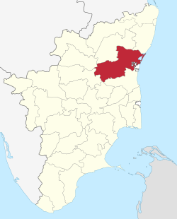
Viluppuram district
| Villupuram district Mavattam | |
|---|---|
| District | |
 | |
 Location in India | |
| Coordinates: 11°57′16.92″N 79°31′39.83″E / 11.9547000°N 79.5277306°ECoordinates: 11°57′16.92″N 79°31′39.83″E / 11.9547000°N 79.5277306°E | |
| Country |
|
| State | Tamil Nadu |
| Municipalities | Viluppuram, Tindivanam, Kallakurichi |
| Largest Town | Tindivanam |
| Headquarters | Viluppuram |
| Talukas | Gingee, Kallakurichi, Sankarapuram, Thindivanam, Thirukoilur, Ulundurpet, Vanur, Viluppuram,Vikkiravandi, Chinnasalem |
| Government | |
| • Collector |
Dr. L. Subramanian, IAS |
| Area | |
| • Total | 7,194 km2 (2,778 sq mi) |
| Area rank | 1 |
| Population (2011) | |
| • Total | 3,458,873 |
| • Rank | 6 |
| • Density | 480/km2 (1,200/sq mi) |
| Languages | |
| • Official | Tamil |
| Time zone | UTC+5:30 (IST) |
| PIN | 604xxx,6056xx,6062xx |
| Telephone code | 04146,04147,04149,04151,04153 |
| Vehicle registration | TN-15,TN-16,TN-32[1] |
| Website |
viluppuram |
Viluppuram (also Villupuram and Vizhupuram) is one of the thirty two districts which make up Tamil Nadu state situated on the southern tip of India. The district headquarters is located at Viluppuram. Viluppuram district came into existence on 30 September 1993 when it was created out of South Arcot district. Viluppuram is the largest district in the state. The district lies in the middle of the Tiruchirapalli to Chennai National Highways No. 45. It is well connected by the rail road and it is major junction. From here one can go to any corner of the Tamil Nadu as well as to other part of India. This district is having variety of tourist spots which are more than 500 years old. The district has temples, mosques and churches which are very old and famous. Villupuram which is located on the bank of thenpennai. It having all government offices in one complex near new bus stand. Gingee fort, auroville, tirukoilur malaikovil, periyar falls (kalrayan hills) and Fossil wood park(Thiruvakkarai) are the main tourist attractions.
Etymology
Viluppuram is named after a class of people known as "Vizhupparaiyar" (விழுப்பரையர்). One of the famous Tamil poets Jayamkondar wrote a book titled "Karanai Vizhupparaiyan madal" (also known as Aadhinatha Valamadal) on the praise of Aadhinathan Vizhupparaiyan who served as a commander in the army of Kulottunga Chola I. The town came to known after the "Vizhupparaiyan" sect named after him. They are also known as "Vizhupaadharaiyar".[2][3] Viluppuram is also affectionately called as "Vizhimaa Nagaram" (விழிமா நகரம்) in Tamil. It means town with wide-eyed people. Others claim that the name comes from the sentence vil vizhuntha puram( வில் விழுந்தபுரம்) which means "Bow fallen land".
History
Viluppuram District was earlier a part of South Arcot District along with Cuddalore District. It was then bifurcated from Cuddalore and became a separate district on 30 September 1993. Because of this, the history of Viluppuram district closely resembles that of Cuddalore.
The Chola were the early rulers. Among these rulers, Karikala Chola was the most famous and powerful.
For a short period, the Cholas were overthrown by Simhavishnu Pallava and the Region came under the Pallava rule for sometime. Vijayalaya Chola again revived Chola rule. This was the beginning of great Chola Empire.
Cholas regained their lost position but with the rise of Jatavarman Sundara Pandya-1 (1251), Chola supremacy came to an end. The sway of Pandyas lasted for over 50 years, followed by Muslim domination from 1334 to 1378. By 1378, the region came under the rule of Vijayanagara Empire and Nayaks were appointed as the rulers of the region.
In 1677 Shivaji took Gingee area with the assistance of Golkonda forces. Then came the Mughals. During the Mughals regime, both the English and French acquired settlements in South Arcot. During the Anglo-French rivalry, the entire district was turned into a war land. After sometime, the entire area came under the control of East India Company. It remained under British authority till 1947 when India became independent.[4]
Economy
In 2006, the Ministry of Panchayatin Raj named Viluppuram one of the country's 250 most backward districts (out of a total of 640).[5] It is one of the six districts in Tamil Nadu currently receiving funds from the Backward Regions Grant Fund Programme (BRGF).[5]
District Administration
At present Vilupuram district comprises 1490 Revenue Villages, 4 Revenue Divisions, 13 Administrative Taluks, 22 Blocks, 15 Town Panchayat Unions, 1099 Village Panchayats and 3 Municipalities.
The General geological formation of the District appears to be simple. The greater part of it is covered by the Metamorphic rocks belonging to Genesis family. There are also three great groups of sedimentary rocks belonging to different geological periods. The Kalrayan Hills in the North represents a continuous range of hills covered with some thorny forests and vegetation. Among the hills, the most beautiful part of the district lies, round about the Gingee Hills.
Taluks
Villupuram district has 13 taluks.
- Viluppuram
- Tirukkoyilur
- Kallakurichi
- Sankarapuram
- Chinnasalem
- Ulundurpettai
- Tindivanam
- Vikravandi
- Vanur
- Gingee
- Marakkanam
- Melmalayanur
- Kandachipuram
Demographics
According to 2011 census, Viluppuram district had a population of 3,458,873 with a sex-ratio of 987 females for every 1,000 males, much above the national average of 929.[6] A total of 404,106 were under the age of six, constituting 208,246 males and 195,860 females. Scheduled Castes and Scheduled Tribes accounted for 29.37% and 2.16% of the population respectively. The majority castes of the district are vanniyar and Adi dravida while the remaining are minorities.The average literacy of the district was 63.48%, compared to the national average of 72.99%.[6] The district had a total of 800,368 households. There were a total of 1,703,249 workers, comprising 322,900 cultivators, 537,581 main agricultural labourers, 23,961 in house hold industries, 376,360 other workers, 442,447 marginal workers, 46,746 marginal cultivators, 294,632 marginal agricultural labourers, 14,276 marginal workers in household industries and 86,793 other marginal workers.[7]
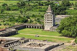
Tourist Attractions
Gingee Fort
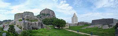
Nestled on three hills and enclosed by a huge rampart 60 feet thick, stands the majestic Gingee Fort. The notable king of the fort is Raja Desingu.
It stands 800 ft. high, guarded by a moat, 80 feet wide. Much of the early history of this 800-year-old fort is shrouded in mystery as it seems to have changed many hands times before it was annexed to the Vijayanagar empire.
The forts are on either side of the road to T. V. Malai. They are open from 8.00 hrs. to 17.00 hrs. Assistance can be sought at the ASI office or the ticket counter.
See also
References
| Wikimedia Commons has media related to Viluppuram district. |
- ↑ "www.tn.gov.in" (PDF). Retrieved 2011-12-18.
- ↑ நாசா விண்வெளி ஆய்வு நடுவத்தில் ஒரு தமிழுள்ளம் [Archive] - தமிழ் மன்றம்.காம்
- ↑ இனியது கேட்கின்!: 08. இஇ - மடப்பாவையார் நம் வசமாக
- ↑ "History of Viluppuram". Viluppuram Municipality.
- 1 2 Ministry of Panchayati Raj (8 September 2009). "A Note on the Backward Regions Grant Fund Programme" (PDF). National Institute of Rural Development. Archived from the original (PDF) on 5 April 2012. Retrieved 27 September 2011.
- 1 2 "Census Info 2011 Final population totals". Office of The Registrar General and Census Commissioner, Ministry of Home Affairs, Government of India. 2013. Retrieved 26 January 2014.
- ↑ "Census Info 2011 Final population totals - Viluppuram district". Office of The Registrar General and Census Commissioner, Ministry of Home Affairs, Government of India. 2013. Retrieved 26 January 2014.
| State symbols |
|
|---|---|
| Governance |
|
| Topics | |
| Districts |
|
| Major cities | |
moolakkadu (village) kalvarayan hills for famous tourist place