Shelkar
| Shelkar ཤེལ་དཀར་ New Tingri / Shegar / Shekar | |
|---|---|
| Xêgar | |
 Shelkar | |
| Coordinates: 28°39′30″N 87°07′20″E / 28.65833°N 87.12222°E | |
| Country | China |
| Province | Tibet Autonomous Region |
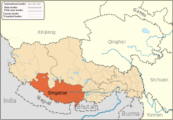
| Prefecture | Shigatse Prefecture |
| County | Tingri County |
| Elevation | 4,330 m (14,210 ft) |
| Population (2000) | |
| • Total | 8,767 |
| Time zone | UTC+8 (CST) |
_in_1921.jpg)
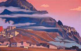
Shelkar or Shekar,[2][1] also the destroyed fortress of Shekar Dzong[1] and destroyed Shekar Monastery[1] (Shelkhar = "white crystal", Tibetan: ཤེལ་དཀར་),[3] also called "New Tingri", is the administrative centre for Tingri County, Shigatse Prefecture in southern Tibet.
Location
The town lies 7 km off the Friendship Highway between Lhatse and Tingri, at the southern foot of 5,260 m high Gyatso La.
Landmarks
Shelkar is famous for the Shelkar Chode Monastery, founded in 1266 by a Kagyu lama, but it has been a Gelugpa monastery since the 17th century, and formerly had some 400[1] monks. Although, destroyed[1] by the Red Guards during the Cultural Revolution, the assembly hall has been rebuilt, and there is an active branch monastery in Boudhanath, Nepal.[4]
The ruins of the old dzong are located on the hill behind the monastery.[5]
Gateway to Everest
The early British expeditions to Mount Everest in 1921, 1922 and 1924 all stopped at Shelkar Dzong on their way from Darjeeling to the northern side of Everest.[6][7]
Footnotes
- 1 2 3 4 5 6 Harvard, Andrew (July 1984). "The Forgotten Face of Everest". The National Geographic Magazine. National Geographic Society. Vol. 166, No. 1: 77.
(Caption for two photos- one "before" and "after" destruction. The "before" photo is shown on this page, while the 1980 "after" photo is not available)- "Casualty of Violence, the great Tibetan monastery at Xegar photographed (right) by a British group on a 1922 reconnaissance of Mount Everest, appears as a magnificent cliffside sanctuary guarded by a walled fortress on the slopes above. Xegar, whose name means "shining crystal" in Tibetan, then housed 400 monks and served as a center of Buddhist teaching and influence. The lower photograph, taken by author Andrew Harvard in 1980, shows the devastation of both fortress and monastery, with nothing remaining of Xegar but the small village at the base of the mountain. Although local residents were reluctant to discuss Xegar's fate, other sources have indicated that the monastery was destroyed by Chinese Communist forces during the Tibetan rebellion of 1959..."
- ↑ Bruce, Charles Granville; Mount Everest Expedition (1922) (1923). The assault on Mount Everest, 1922. Snell Library Northeastern University. New York: Longmans, Green. pp. 338 (Index). OCLC 220914742.
- ↑ Strachey 1854, p. 4.
- ↑ Dorje 1999, pp. 296–297.
- ↑ http://kekexili.typepad.com/life_on_the_tibetan_plate/2009/12/shelkar.html
- ↑ See Howard-Bury, Charles and Leigh-Mallory, George Herbert (1922) Mount Everest: the reconnaissance, 1921 Longmans, Green and Company, New York, pages 96 and 120, OCLC 3767054,
- ↑ Anderson, Ken "George Mallory to Sherpa Tenzing - Conquering Mighty Everest", accessed 23 August 2010
References
- Dorje, Gyurme (1999). Footprint Tibet Handbook with Bhutan (2nd ed.). Bath, England: Footprint Handbooks. ISBN 1-900949-33-4.
- Strachey, Henry (1854). "Physical Geography of Western Tibet". Journal of the Royal Geographical Society. XXIII: 1–69, plus map. ISSN 0266-6235.
External links
- Photograph of Shekar Dzong in 1924 at The Bentley Beetham Collection
| County-level divisions |
|  | ||||
|---|---|---|---|---|---|---|
| Settlements | ||||||
| Landmarks | ||||||
| Geography | ||||||
| Transport |
| |||||