Dindigul
| Dindigul திண்டுக்கல் | |
|---|---|
| City | |
 | |
| Nickname(s): திண்டுக்கல் பூட்டு,மல்லிகைபூ | |
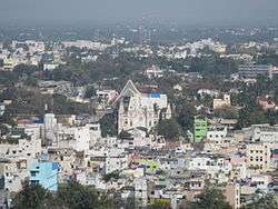
 Dindigul Location in Tamil Nadu, India | |
| Coordinates: 10°21′N 77°57′E / 10.35°N 77.95°ECoordinates: 10°21′N 77°57′E / 10.35°N 77.95°E | |
| Country |
|
| State | Tamil Nadu |
| District | Dindigul |
| Region | Pandyan Dynasty |
| Division | Madurai |
| Government | |
| • Type | Municipal Corporation |
| • Body | Dindigul City Municipal Corporation |
| • Mayor | Vacant |
| • Vice Chairperson | Mr. Veerakumar |
| Area | |
| • Total | 14.96 km2 (5.78 sq mi) |
| Elevation | 268 m (879 ft) |
| • Rank | 12 |
| Demonym(s) | Dindigulite |
| Languages | |
| • Official | Tamil |
| Time zone | UTC+05:30 (IST) |
| PIN | 624001 |
| Telephone code | +91-451 |
| Vehicle registration | TN-57/TN-94 |
| Website | Dindigul Municipal Corporation |
Dindigul (Tiṇṭukkal) is a city in the South Indian state of Tamil Nadu. It is the administrative headquarters of the Dindigul district. Dindigul is located 420 km (260 mi) southwest of the state capital, Chennai, 100 km (62 mi) away from Thiruchirapalli and 66 km (41 mi) away from Madurai.
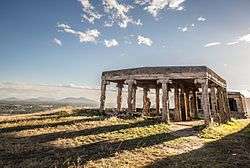
Dindigul District is Located in Madurai Region, Dindigul is believed to be an ancient settlement; it has been ruled at different times by the Early Pandyan Kingdom, the Medieval Cholas, Pallava dynasty, the later Pandyas, the Madurai Sultanate, the Dindigul Sultanates, the Vijayanagara Empire, the Madurai Nayak Dynasty, Chanda Sahib, the Carnatic kingdom and the British. Dindigul has a number of historical monuments, the Rock Fort being the most prominent.
Industries in Dindigul include safety lock makers, leather tanneries,textile spinning, administrative services, agricultural trading, banking, agricultural machinery and educational services. Dindigul is upgraded to a municipal corporation. The city covers an area of 14.01 km2 (5.41 sq mi) and had a population of 207,327 in 2011. Dindigul is well-connected by road and rail with the rest of Tamil Nadu.[1] It is the 12th-largest urban agglomeration in the state and has a population of 292,512 according to Tamil Nadu's 2011 census. Dindigul has 200,000 hectares of cultivation land, and agriculture continues to be the main occupation of its inhabitants. Located between the Palani and Sirumalai Hills, Dindigul has a reserved forest area of 85 hectares.[2] Vadamadurai is one of the main towns in dindigul district where alagar temple(Sri Ranganadha swamy) is located which a famous temple in south India and surrounded with hills and greens and villages located nearby are Seethapati, Thennampati, etc.
Etymology
The city's name comes from a portmanteau of the Tamil words dind "pillow" and kal rock and refers to the bare hill located near the city. The Śaiva poet Tirunāvukkarasar visited the city and noted it in his Tevaram. Dindigul finds mention in the book Padmagiri Nadhar Thenral Vidu thudhu written by the poet Palupatai sokkanathar as Padmagiri. This was later stated by U. V. Swaminatha Iyer (1855-1942) in his foreword to the above book. He also mentions that Dindigul was originally called Dindeecharam.[3]
History

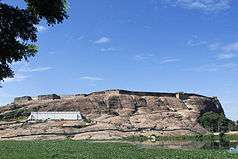
The history of Dindigul is centered around the fort over the small rock hill and fort. Dindigul region was the border of the three prominent kingdoms of South India, the Pandyas, Cheras and Cholas. The Chera king Dharmabalan is believed to have built the temples of Abirami and Padmagirinathar. The ancient Tamil book, Silappathikaram records the city as the northern border of the Pandya kingdom whose capital was Madurai. Historian Strabo mentions about the city in his 20 A.D. work and Pillni, the great historian of the time described the Pandya king in his works.[3]
During the first century A.D., the Chola king Karikal Cholan captured the Pandya kingdom and Dindigul came under the Chola rule. During the sixth century, the Pallavas took over most provinces of Southern India. Dindigul was under the rule of Pallavas until Cholas regained the state in the 8th century. In the 14th century, South India was invaded by the Delhi Sultanate. Dindigul was safe in the hands of VijayaNagara . The commander of the Vijaya Nagar army Kampanna Udayar played an important role in the war in capturing Madurai which was under Madurai sultanate. In 1559 Nayaks became powerful and their territory bordered with Dindigul in the north. After the death of king Viswanatha Nayak in 1563, Muthukrisna Nayakka became the king of a kingdom in 1602 A.D who built the strong hill fort in 1605 A.D. He also built a fort at the bottom of the hill. Muthuveerappa Nayak and Thirumalai Nayak followed Muthukrishna Nayak. Dindigul came to prominence once again during Nayaks rule of Madurai under Thirumalai Nayak. After his immediate unsuccessful successors, Rani Mangammal became the ruler of the region who ruled efficiently.[3]
In 1736 Chanda Sahib, the lieutenant of Mughal Empire seized power from Vangaru Nayak. In 1742, the Mysore army under the leadership of Venkatarayer conquered Dindigul. He governed Dindigul as a representative of Maharaja of Mysore. There were Eighteen Palayams (a small region consists of few villages) during his reign and all these palayams were under Dindigul Semai with Dindiguls capital. These palayams wanted to be independent and refused to pay taxes to venkatarayer.[3][4] In 1748, Venkatappa was made governor of the region in place of Venkatarayer, who also failed. In 1755, Mysore Maharaja sent Haider Ali to Dindigul to handle the situation. Later Haider Ali became the Maharaja of Mysore and in 1777, he appointed Purshana Mirsaheb as governor of Dindigul. He strengthened the fort. His wife Ameer-um-Nisha-Begam died during her delivery and her tomb is now called Begambur. In 1783 British Army, led by Captain Long invaded Dindigul. In 1784, after an agreement between the Mysore province and British army, Dindigul was restored by Mysore province. In 1788, Tipu Sultan, the Son of Haider Ali, was crowned as King of Dindigul.[3][5][6][7] In 1790, James Stewart of the British army gained control over Dindigul by invading it in the second war of Mysore. In a pact made on 1792, Tipu ceded Dindigul to the English. Dindigul is the first region to come under English rule in the Madurai District. In 1798, the British army strengthened the hill fort with cannons and built sentinel rooms in every corner.The British army, under Statten stayed at Dindigul fort from 1798 to 1859. After that Madurai was made headquarters of the British army and Dindigul was attached to it as a taluk. Dindigul was under the rule of the British Until India got our Independence on 15 August 1947.[3][5]
Geography
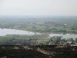
Dindigul is located at 10°21′N 77°57′E / 10.35°N 77.95°E[8] and has an average elevation of 265 m (869 ft). The town is in Dindigul district of the South Indian state, Tamil Nadu, 420 km (260 mi) from Chennai and 100 km (62 mi) south-west of Tiruchirappalli. Dindigul is located in the foothills of Sirumalai hills. The topography is plain and hilly, with the variation resulting in climatic changes. There are no notable mineral resources available in and around the town. The soil type is thin veeneer soil, which is mostly black clayey soil with red soil. Summer season is from March to July, while December to January marks the winter season. The temperature ranges from a maximum of 37 °C (99 °F) to a minimum of 29 °C (84 °F) during summer and a maximum of 26 °C (79 °F) to a minimum of 20 °C (68 °F) during winter. Dindigul receives rainfall with an average of 812 mm (32.0 in) annually. The Southwest monsoon, with an onset in June and lasting up to August, brings scanty rainfall. Bulk of the rainfall is received during the North East monsoon in the months of October, November and December.[9]
Demographics
| Historical population | ||
|---|---|---|
| Year | Pop. | ±% |
| 1901 | 25,182 | — |
| 1911 | 25,052 | −0.5% |
| 1921 | 30,922 | +23.4% |
| 1931 | 43,617 | +41.1% |
| 1941 | 56,275 | +29.0% |
| 1951 | 78,361 | +39.2% |
| 1961 | 92,947 | +18.6% |
| 1971 | 128,429 | +38.2% |
| 1981 | 164,103 | +27.8% |
| 1991 | 182,477 | +11.2% |
| 2001 | 196,619 | +7.8% |
| 2011 | 207,327 | +5.4% |
| Sources: | ||
According to 2011 census, Dindigul had a population of 207,327 with a sex-ratio of 1,012 females for every 1,000 males, much above the national average of 929.[12] A total of 19,603 were under the age of six, constituting 10,126 males and 9,477 females. Scheduled Castes and Scheduled Tribes accounted for 7.58% and .07% of the population respectively. The average literacy of the city was 81.69%, compared to the national average of 72.99%.[12] The city had a total of 53573 households. There were a total of 77,813 workers, comprising 387 cultivators, 366 main agricultural labourers, 5,328 in house hold industries, 68,163 other workers, 3,569 marginal workers, 46 marginal cultivators, 176 marginal agricultural labourers, 187 marginal workers in household industries and 3,160 other marginal workers.[11] As per the religious census of 2011, Dindigul had 69.11% Hindus, 14.17% Muslims, 31.59% Christians, 0.02% Sikhs, 0.02% Buddhists, 0.01% Jains and 0.1% following other religions.[13]
As of the provisional population totals of 2011 census, Dindigul urban agglomeration had a population of 292,132, with 145,438 males and 146,694 females. The sex ratio of the town was 1,009 females per 1,000 males; the child sex ratio stood at 964. Dindigul had an average literacy rate of 89.1% with a male literacy of 93.41% and a female literacy of 84.83%. A total of 26,169 of the population of the town was under 6 years of age.[14]
As of 2001, 15 slums were identified in the town and a total of 85,235 people resided in the slums in 16,841 households. The slum population increased from 16 per cent to 43 per cent during the period of 1991–2001. The town experienced a growth rate of 28 per cent to 40 per cent during the 70s, but declined to 11 percent in 80s and 8 percent in 90s due to lack of economic opportunities and growth of adjacent city Madurai.[15]
The city covers an area of 14.01 square kilometres (5.41 sq mi). The population density of the city in the 2001 census was 153 persons per hectare, compared with 2,218 persons per square kilometer in 1971. The density of population is higher in the central areas and along major roads. Hindus form the majority of the urban population, followed by Muslims and Christians. Tamil is the main language spoken in the city, but the use of English is relatively common; English is the medium of instruction in most educational institutions and offices in the service sector.[16]
Economy
According to Indian Census of 2001, Dindigul town’s urban workforce participation rate is 35.24 percent. Dindigul, being the headquarters of the district, has registered growth in the secondary and tertiary sectors, with a corresponding decrease in the primary Sector. Major employment in the city is provided by industrial estates, hand loom, trading and commerce activities. Approximately 90 percent of the workforce is employed in the tertiary sector. The district at large has only two industrial estates, with one of them located in the city. As of 2001, there were approximately 60 tanneries, 165 lock manufacturing units and large number of cotton spinning mills.[17]
Locks and steel safes are manufactured in Dindigul and operated as a co-operative sector. Locks manufactured in Dindigul are sold in national and international markets and is well known all over India for its quality. The Tamil Nadu State Council for Science and Technology, through its research officers wing, has filed geographical indication for Dindigul locks.[18] A decline in lock industry is observed in modern times and other industries like leather, handloom, and aggro opportunities have gained significance. Silk, muslin and blanket manufacturing is common in Dindigul and after Coimbatore, the city has the second largest textile spindling capacity in the State. Chinnalapatti silk, a brand of silk saree is produced out of Chinnalapatti located 11 km (6.8 mi) from the city.[2] The climate condition of the region is conducive for horticulture and agriculture. The district at large produce non-food crops like coffee, flowers, tobacco, and eucalyptus. Dindigul is the center for wholesale trading of fruits like orange, pineapple, sapota and guava, and vegetables like onion.[17]
Dindigul was an important center of trade in tobacco and manufacture of cigars during the British times.[19] A favorite cigar of Winston Churchill called Churut, the 'Light of Asia', was produced in Dindigul. The tobacco industry is one of the main sources of employment for the inhabitants of Dindigul.The central government has a research center for tobacco in Vedasandur. This is one of the two centers in India, the other one is Rajamundri. In modern times, it has the largest trading center in the state for chewing tobacco and scented betel nuts. Well-known brands of scented chewing tobacco like Angu Vilas, Roja Supari etc. operate out of the city and sent to various places in the state and outside. Dindigul is also one of the leading leather producers and suppliers in the state.[2]
Municipal administration and Politics
| Corporation officials | |
|---|---|
| Mayor | V. Marutharaj[20] |
| Deputy Mayor | M. Tulsiram[21] |
| Commissioner | T. Kumar[22] |
| Elected members | |
| Member of Legislative Assembly | Dindigul C. Sreenivasan[23] |
| Member of Parliament | M. Udhayakumar[24] |
On 1 November 1866, Dindigul became a municipality.[3] It was promoted to a special-grade municipality as of 1988 and the entire municipal area was included in the jurisdiction of the municipality.[25] On 10 April 2013, it was announced that the municipality would be upgraded to a municipal corporation.[26][27] On 19 February 2014, Chief Minister of Tamil Nadu, J. Jayalalithaa declared that Dindigul Municipality has been upgraded to Corporation status with immediate effect. The said government order was handed over to the Municipal Chairman, G. Marudharaj[28] The Dindigul municipality has 48 wards and there is an elected councillor for each of those wards.[29] The functions of the municipality are devolved into six departments: general administration/personnel, Engineering, Revenue, Public Health, city planning and Information Technology (IT). All these departments are under the control of a Municipal Commissioner who is the executive head.[30] The legislative powers are vested in a body of 48 members, one each from the 48 wards.[31] The legislative body is headed by an elected Chairperson assisted by a Deputy Chairperson.[32]
Dindigul comes under the Dindigul assembly constituency and it elects a member to the Tamil Nadu Legislative Assembly once every five years.[33] From the 1977 elections, All India Anna Dravid Munnetra Kazhagam (AIADMK) won the assembly seat two times (in 1984 and 1991 elections); Communist Party of India (Marxist) (CPI(M)) six times (1977, 1989, 1996, 2001, 2006 and 2011) and once by Dravida Munnetra Kazhagam (DMK, 1996).[34] The current MLA of the constituency is C.Sreenivasan from AIADMK party.[23]
Dindigul is a part of the Dindigul Lok Sabha constituency and elects its member to Parliament once in five years. The constituency was held by the Indian National Congress four times (1957, 1962, 2004 and 2009 elections),[24][35][36][37] Dravida Munnetra Kazhagam (DMK) three times (1967, 1971 and 1980 elections),[38][39][40] Anna Dravida Munnetra Kazhagam (ADMK) for seven times (1977, 1984, 1989, 1991, 1998, 1999 and 2014 elections)[41][42][43][44][45][46] and by Tamil Maanila Congress (TMC) once (1996 elections).[47] The current Member of Parliament from the constituency is M. Udhayakumar from the AIADMK party.[24]
Law and order in the town in maintained by the Dindigul sub division of the Tamil Nadu Police headed by a Deputy Superintendent. There are three police stations in the town, one of them being an all-women police station. There are special units like prohibition enforcement, district crime, social justice and human rights, district crime records and special branch that operate at the district level police division headed by a Superintendent of Police.
Education and utility services

As of 2011, there are 19 municipal primary schools, 23 other primary schools, eight middle schools and 13 higher secondary schools in the city. There were ten other private schools within the town. There were three engineering colleges and three arts and science colleges. Gandhigram Rural university and Mother Teresa Women's University are the two universities present in Dindigul.[48]
Electricity supply to Dindigul is regulated and distributed by the Tamil Nadu Electricity Board (TNEB). The town along with its suburbs forms the Dindigul Electricity Distribution Circle. A Chief Distribution engineer is stationed at the regional headquarters.[49] Water supply is provided by the Dindigul Municipal Corporation from Athoor Kamarajar Water Supply Scheme (9.6 MLD), Peranai Water Supply Scheme (7.5 MLD) and Cauvery combined water supply Scheme (6-10 MLD). As of 2001, the total water supply of the town in 14 MLD everyday.[50] As per the municipal data for 2011, about 92 metric tonnes of solid waste were collected from Dindigul every day by door-to-door collection and subsequently the source segregation and dumping was carried out by the sanitary department of the Dindigul municipality.[51] There is no underground drainage system in the town and the sewerage system for disposal of sullage is through septic tanks, open drains and public conveniences.[52]
The municipality maintained a total of 117.0 km (72.7 mi) of storm water drains in 2011.[53] As of 2011, the municipality maintained a total of 5,489 street lamps: 754 sodium lamps, 173 mercury vapour lamps, 4,551 tube lights and eight high mast beam lamp.[54] The municipality operates one daily market, namely the Dindigul Municipal Market that cater to the needs of the town and the rural areas around it.[55]
The municipality maintains four dispensaries, five maternity homes, eight family planning centres, three Siddha and one Ayurvedic centre. The Government District Headquarters Hospital is located in Dindigul and has 350 beds. The town has more than five private hospitals, 35 maternity centres, 15 laboratries and one blood bank. The historic St. Joseph Mission Hospital with a bed strength of 250 beds is one of the major hospitals in the city. For all the advanced health care systems, Madurai city is the nearest destination.[56]
Transportation
The Dindigul city corporation maintains 131.733 km (81.855 mi) of roads. The town has 21.66 km (13.46 mi) concrete roads, 98.311 km (61.088 mi) bituminous roads, 9.352 km (5.811 mi) earthen roads and 2.41 km (1.50 mi) cut stone pavements. There are three national highways, NH 44 (largest highway in India) connecting Dindigul to Madurai and NH 45A connecting Chennai to Kanyakumari, and NH 83 Coimbatore to Nagapattinam via Palani, Dindigul, Tiruchirapalli, Thiruvarur via the city. Natham road and Bathalagundu road are the two state highways that pass via the city. Being the district headquarters, lot of district roads also connect Dindigul to other parts of the district.[57][58]
Dindigul is served by town bus service, which provides connectivity within the town and the suburbs. Minibus service operated by private companies cater to the local transport needs. There are 150 town buses operated daily across 128 different routes.[9] The Kamarajar bus stand is an A-grade bus stand covering an area of 5.37 acres (21,700 m2) as of 2007 and is located in the heart of the town.[59][60] The Tamil Nadu State Transport Corporation operates daily services connecting various cities to Dindigul.[60][61][62] The State Express Transport Corporation operates long distance buses like Chennai, Bengaluru and Tirupati. There is significant truck transport with around 400–450 trucks entering the town for loading and unloading activities daily. Three wheelers, called autos and Call Taxi are also a common public transport system.[60]
Dindigul railway station was established in 1875 when rail line for Trichy to Tuticorin was constructed.[3] Dindigul railway junction is located in the rail head from Chennai to Madurai and Karur to Madurai. It is also connecting Dindigul to Palani. All south bound trains plying south to Madurai from Chennai pass via Dindigul. There are also passenger trains running either side from Madurai to Tiruchirapalli and Palani. The nearest local and international airport is Madurai Airport located 70 kilometres (43 mi) away.[62]
Culture

Dindigul is the 18th Shakthi Peetam known as "Sri Abhiraamaa Peetam".[63][64]
Numerous temples, mosques and churches are found in Dindigul.
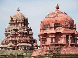
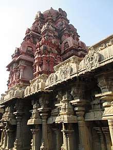
The Kalahastheeswara-Gnanambika temple was built during the 14th century. The Seenivasaperumal temple built in the bottom of the hill was eroded by time. By the 16th century Pandyan acquired the whole chera kingdom with the support of Vijayanagar king Sachudevarayer. Sachudevarayer, on his visit in 1538 A.D. ordered for the repair works of the temple of Abirami Amman and Padmagirinathar. This is inferred from the script written over stone in the Fort temple. Muthukrisna Nayak became the king of Pandaya kingdom in 1602 A.D. He built the strong hill fort in 1605 to secure Dindigul from invasion. He also built a fort at the bottom of the hill, which was later called Pettaiwall .Thirumalai Nayak redressed the Hill fort and he built the front hall of the Kalahastheeswaraswamy temple. Soundararaja Perumal temple in Thadikombu was erected during his reign. During his Nayak's stay in Dindigul, he fell into sickness and believed to have prayed Rangaperumal to relieve his sickness. Rani Mangammal built the six hundred steps for the hill fort.[3][65] during the months of January and February, a festival honoring Mariamman is celebrated in this temple.It has famous sri abirami amman temple,which is reconstructed.[66] Arulmigu Abirami Amman temple is a holy place situated in Dindigul in Tamil Nadu, India. This is one of the important ‘Shivasthalam’ were you can find Padmagiriswarar – Abirami Amman and Kalahastheeswarar – Gnanambigai Sannathi’s. The rock hill is called Padmachala, Padmagiri,Lotus Hill.[67]
Begumbur Periya Pallivasal, Dindigul, Thowheeth Masjid, Ahle Hadees Pallivasal, Bajar Masjid, Mohammadiyapuram Pallivasal, Mandi Pallivasal, Madinah Pallivasal, Ring Road Pallivasal and Makkah Pallivasal are some of the Islamic institutions in Dindigul.St.
Joseph’s Church at the heart of the town is known for its vast space and the famous architecture which is evident from the glass works and special artistic work all over the church. The church was built between 1866 and 1872. It is the headquarters of Dindigul diocese of Roman Catholic Churches in Dindigul[68]Dindigul Biryani is a common and popular dish, and Dindigul is sometimes called Biryani City.[69][70]
See also
Notes
- ↑ "Tamil Nadu News : Dindigul District – A Profile". The Hindu. Retrieved 2013-03-03.
- 1 2 3 "Tamil Nadu News : A heady mix of all, for all". The Hindu. 2008-05-31. Retrieved 2013-03-03.
- 1 2 3 4 5 6 7 8 9 "Historical moments". Dindigul municipality. 2011. Archived from the original on 2009-07-29. Retrieved 2012-12-29.
- ↑ Nelson 1989, p. 258
- 1 2 Nelson 1989, pp. 286-93
- ↑ Hasan, Mohibbul (2005). History of Tipu Sultan. Aakar Books. pp. 68–69. ISBN 81-87879-57-2.
- ↑ Beveridge, Henry (1867). A comprehensive history of India, civil, military and social, from the first landing of the English, to the suppression of the Sepoy revolt:including an outline of the early history of Hindoostan, Volume 2. Blackie and son. pp. 222–24.
- ↑ "Falling Rain Genomics, Inc – Dindigul". Falling Rain Genomics Inc.
- 1 2 "About city". Dindigul municipality. 2011. Archived from the original on 2009-05-16. Retrieved 2012-12-29.
- ↑ Urban Infrastructure Report 2008, pp. 2-4
- 1 2 "Census Info 2011 Final population totals - Dindigul". Office of The Registrar General and Census Commissioner, Ministry of Home Affairs, Government of India. 2013. Retrieved 26 Jan 2014.
- 1 2 "Census Info 2011 Final population totals". Office of The Registrar General and Census Commissioner, Ministry of Home Affairs, Government of India. 2013. Retrieved 26 Jan 2014.
- ↑ "Population By Religious Community - Tamil Nadu" (XLS). Office of The Registrar General and Census Commissioner, Ministry of Home Affairs, Government of India. 2011. Retrieved 13 September 2015.
- ↑ "Provisional Population Totals, Census of India 2011; Cities having population 1 lakh and above" (PDF). Office of the Registrar General & Census Commissioner, India. p. 12. Retrieved 2012-12-29.
- ↑ Urban Infrastructure Report 2008, p. 8
- ↑ Urban Infrastructure Report 2008, p. 4
- 1 2 Urban Infrastructure Report 2008, pp. 7-9
- ↑ "Tamil Nadu / Madurai News: Geographical Indication likely for Thanjavur Veena, Dindigul Lock". The Hindu. 2009-08-09. Retrieved 2013-03-03.
- ↑

- ↑ "Chairman of municipality". Dindigul municipality. 2011. Archived from the original on 2014-03-13. Retrieved 2012-12-29.
- ↑ "Vice Chairman of municipality". Dindigul municipality. 2011. Archived from the original on 2014-03-13. Retrieved 2012-12-29.
- ↑ "Commissioner of municipality". Dindigul municipality. 2011. Archived from the original on 2009-04-08. Retrieved 2012-12-29.
- 1 2 "MLA of Dindigul". Government of Tamil Nadu. 2016.
- 1 2 3 "Members of Lok Sabha from Tamil Nadu". Government of Tamil Nadu. 2014. Retrieved 26 May 2014.
- ↑ "About Municipality". Dindigul municipality. 2011. Archived from the original on 16 September 2012. Retrieved 29 December 2012.
- ↑ "Thanjavur Corporation". The Hindu. 2013. Retrieved 2013-04-14.
- ↑ "Thanjavur to be upgraded as City Municipal Corporations". deccanchronicle.com. 2013. Archived from the original on 2013-04-14. Retrieved 2013-04-11.
- ↑ "Dindigul becomes Corporation". The Hindu. Dindigul. 20 February 2014. Retrieved 20 February 2014.
- ↑ "About the municipality". Dindigul municipality. 2011. Retrieved 2012-12-29.
- ↑ "Commissionerate of Municipal Administration". Commissionerate of Municipal Administration. 2006. Archived from the original on 2012-11-06. Retrieved 2012-12-29.
- ↑ "Councillors of municipality". Dindigul municipality. 2011. Archived from the original on 2014-02-25. Retrieved 2012-12-29.
- ↑ "Economic and political weekly, Volume 30". Sameeksha Trust. 1995: 2396.
- ↑ "List of Assembly Constituencies". Tamil Nadu. Tamil Nadu state government. 2010. Archived from the original on 2012-06-14. Retrieved 2012-12-28.
- ↑ "Partywise Comparison Since 1977". Election Commission of India. 2011. Retrieved 2012-12-29.
- ↑ "Key highlights of the general elections 1957 to the Second Lok Sabha" (PDF). Election Commission of India. p. 17. Retrieved 2012-12-29.
- ↑ "Key highlights of the general elections 1962 to the Third Lok Sabha" (PDF). Election Commission of India. p. 49. Retrieved 2012-12-29.
- ↑ "Key highlights of the general elections 2004 to the Fourteenth Lok Sabha" (PDF). Election Commission of India. p. 94. Retrieved 2012-12-29.
- ↑ "Key highlights of the general elections 1967 to the Fourth Lok Sabha" (PDF). Election Commission of India. p. 67. Retrieved 2012-12-29.
- ↑ "Key highlights of the general elections 1971 to the Fifth Lok Sabha" (PDF). Election Commission of India. p. 71. Retrieved 2012-12-29.
- ↑ "Key highlights of the general elections 1980 to the Seventh Lok Sabha" (PDF). Election Commission of India. p. 79. Retrieved 2012-12-29.
- ↑ "Key highlights of the general elections 1977 to the Sixth Lok Sabha" (PDF). Election Commission of India. p. 80. Retrieved 2012-12-29.
- ↑ "Key highlights of the general elections 1984 to the Eighth Lok Sabha" (PDF). Election Commission of India. p. 73. Retrieved 2012-12-29.
- ↑ "Key highlights of the general elections 1989 to the Ninth Lok Sabha" (PDF). Election Commission of India. p. 81. Retrieved 2012-12-29.
- ↑ "Key highlights of the general elections 1991 to the Tenth Lok Sabha" (PDF). Election Commission of India. p. 51. Retrieved 2012-12-29.
- ↑ "Key highlights of the general elections 1998 to the Twelfth Lok Sabha" (PDF). Election Commission of India. p. 85. Retrieved 2012-12-29.
- ↑ "Key highlights of the general elections 1999 to the Thirteenth Lok Sabha" (PDF). Election Commission of India. p. 85. Retrieved 2012-12-29.
- ↑ "Key highlights of the general elections 1996 to the Eleventh Lok Sabha" (PDF). Election Commission of India. p. 86. Retrieved 2012-12-29.
- ↑ "Educational Institutions". Dindigul municipality. 2011. Archived from the original on 2013-06-24. Retrieved 2012-12-29.
- ↑ "Important Address" (PDF). Indian Wind Power Association. 2011. Archived from the original (PDF) on 2012-10-16. Retrieved 2012-12-29.
- ↑ "Water Supply Details". Dindigul Municipality. 2011. Archived from the original on 2013-06-24. Retrieved 2012-12-29.
- ↑ "Waste management programme". Dindigul Municipality. 2011. Archived from the original on 2013-06-24. Retrieved 2012-12-29.
- ↑ "Dindigul sewarage". Dindigul municipality. 2011. Archived from the original on 2013-06-24. Retrieved 2012-12-29.
- ↑ "Storm water drains of Dindigul". Dindigul municipality. 2011. Archived from the original on 2013-06-24. Retrieved 2012-12-29.
- ↑ "Dindigul street lights". Dindigul Municipality, Government of Tamil Nadu. 2011. Archived from the original on 2013-06-24. Retrieved 2012-12-29.
- ↑ "Dindigul markets". Dindigul Municipality, Government of Tamil Nadu. 2011. Archived from the original on 2013-06-24. Retrieved 2012-12-29.
- ↑ Urban Infrastructure Report 2008, p. 9
- ↑ "Dindigul roads". Dindigul municipality. 2011. Archived from the original on 2013-10-04. Retrieved 2012-12-29.
- ↑ Urban Infrastructure Report 2008, p. 40
- ↑ "Dindigul bus stand". Dindigul municipality. 2011. Archived from the original on 2014-04-07. Retrieved 2012-12-29.
- 1 2 3 Urban Infrastructure Report 2008, p. 64
- ↑ "S.E.T.C. Tamil Nadu Ltd., Computer reservation centres". Tamil Nadu State Transport Corporation Ltd. 2011. Retrieved 2012-12-29.
- 1 2 "Dindigul how to reach". Dindigul municipality. 2011. Archived from the original on 2014-04-13. Retrieved 2012-12-29.
- ↑ https://en.wikipedia.org/wiki/Shakti_Peetha#18_Maha_Shakti_Pithas
- ↑ https://archive.org/details/AbiramiammanSthalaPuranam
- ↑ "Trial run of Sri Kottai Mariamman temple car draws huge crowd". The Hindu. 2011-02-08.
- ↑ https://www.google.co.in/destination?q=dindigul&sa=X&rlz=1C1CHWA_enIN624IN624&tcfs=%5B%5D&site=search&output=search&dest_mid=%2Fm%2F06dscc
- ↑ http://www.dindigulabiramiammantemple.tnhrce.in
- ↑ http://catholiconline.in/st-josephs-church-dindigul/
- ↑ "Business Line : Features / Life News". Thehindubusinessline.com. Retrieved 2013-03-03.
- ↑ "Metro Plus Madurai / Food : Biryani bistro". The Hindu. 2010-03-11. Retrieved 2013-03-03.
References
- Nelson, James Henry (1989). The Madura Country: A Manual. Asian Educational Services. ISBN 9788120604247.
- Urban Infrastructure report (2009). Conversion of City Corporate Plan into Business Plan (PDF) (Report). Tamil Nadu Urban Infrastructure Financial Services Limited. Retrieved 2012-12-29.
External links
| Wikimedia Commons has media related to Dindigul. |
| State symbols |
|
|---|---|
| Governance |
|
| Topics | |
| Districts |
|
| Major cities | |