Attur
| Attur Aaththur | |
|---|---|
| Town | |
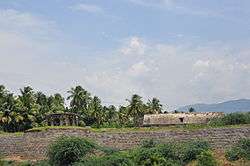 Attur Fort | |
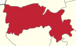
 Attur Location in Tamil Nadu, India | |
| Coordinates: 11°35′58″N 78°35′52″E / 11.599341°N 78.597752°ECoordinates: 11°35′58″N 78°35′52″E / 11.599341°N 78.597752°E | |
| Country |
|
| State | Tamil Nadu |
| District | Salem |
| Government | |
| • Type | Selection Grade Municipality |
| • Body | Attur Municipality |
| Elevation | 212 m (696 ft) |
| Population (2011) | |
| • Total | 100,000 |
| Languages | |
| • Official | Tamil |
| Time zone | UTC+5:30 (IST) |
| PIN | 636 102 |
| Telephone code | 04282 |
| Vehicle registration | TN-77, TN-54 X,Y,Z |
| Website |
www |
Attur or Aaththur is a town, municipality and headquarters of Attur taluk in the Salem district in the state of Tamil Nadu, India. It is known as Sago City.As of 2011 census, the town had a population of 61,793. Outgrowth of Attur town is Narasingapuram Municipality with population of 23,084[1]. Total Urban Agglaromation population of Attur town is around 1,00,000.
Attur is the second largest town in the district after the district capital Salem and centre for Salem East District. Creation of ATTUR DISTRICT with areas comprising Salem East District is a long term demand of the people[2]. Attur Taluk is surrounded by Gangavalli Taluk on east and Pethanaickenpalayam Taluk on the west. According to the 2011 census, the taluk of Attur had a population of 429,296 with 215,626 males and 213,670 females[3].The villages nearby are Manivizhundhan North, Manivizhundhan South, North Pudur and South Pudur.
Attur was promoted as a Third Grade municipality in 1965, Then Promoted as Second Grade Municipality in 16/04/1970, In 01/04/1975 Upgraded as First Grade Municipality . In 2008, Attur was upgraded as Selection Grade Municipality[4]. Narasingapuram[5], Suburb of Attur, is also a Municipality (Second Grade Municipality).
Etymology
The name of the town derives from the word "Aaaru", meaning "River" and "Ootru ooru", meaning "fountain" - Vasishta Nadi (literally, Attur "River Town"). Attur is one of the king's city. This name of the city call for the reason in long long years ago the situated in the river banks vasista nadhi took the water from this river by making the fountain by their hand.
History
C.Lakshmana Nayakan (17th Century), local Palayakarar, built the Attur Fort. Gatti Mudalis built the temples inside the fort. Attur has an ancient fort with all facilities and is one of the busy business centers in Salem till date. People are very generous, soft natured and have great tendency to help others and for the down-trodden. Under Madurai Nayaks[edit source]
Attur fort
The Fort was constructed by a local Palaiyakkarar chieftain Lakshmana Nayakan under Madurai Nayaks[1] . Attur fort became part of Mysore Kingdom in late 17th century when frequent wars between Mysore Kingdom and Thirumalai Nayak of Madurai when large parts of north west Tamil region from Dindigul became part of Mysore rulers.
Under Mysore Kingdom: The region became part of Mysore Wodeyar rulers and later under Hyder Ali of Mysore till 1768, when surrendered to Wood of East India Company. Hyder Ali regained the town from the British East India Company, but the Company won a decisive victory in the 3rd Mysore war was against Tipu Sultan, the son of Hyder Ali.
Under British: After the Third Mysore War the region became part of Madras Presidency under British.The fort was used by the British as a garrison from 1792 by and the 23rd Madras battalion under the command of captain compbell occupied it. During subsequent years, the fort was used as an ordinance station from 1799 as the Company troops moved to Sankagiri. After 1854, the fort ceased to act as an operational fortress and the region was clubbed into the newly formed Salem District under the Madras Presidency.
Recent status: In modern times, the fort is under the control of the Archaeological Department of the Government of Tamil Nadu. Some portions of the fort is dilapidated, while most other portions are enchorached by slum dwellers.[2][3][4] In modern times, the fort is maintained by the Archaeological Survey of India.[5]
Architecture:
Attur fort situated on the banks of vashistha nadhi The fort occupies an area of 62 acres (250,000 m2) The walls of the fort are about 30 ft (9.1 m) tall and 15 ft (4.6 m) wide. It is decortated by wedge shaped cut-stones fitted without mortar. The construction material for the walls are believed to be quarried from the Kalladithankundru. The fort was guarded by the river in the east and by moats on other sides. Gatt dynasty used the large chamber inside the fort as audience hall during their regime. The pool house, used for the pleasure of the royal family, was fed from the river through a water gate.[6]
Economy
Attur is the main shopping center for the region. Attur region is principally an agricultural area. The economy of the town also depends on agriculture and allied activities. Attur is also famous for tapioca (cassava roots), and there are several tapioca-based industries today which manufacture products like "javvarisi" (sago) for markets all over India. It has many medicinal plant cultivars. Some of them are MGP (Coleus-medicinal plant), south India herbs (coleus). Attur is the main exporting center for Betel leaves to North Indian cities besides Tamil Nadu Towns. There are more than fifteen betel mandies located within the Attur Town in addition to twenty more finding place around the town.
| Category | Number |
|---|---|
| Sago Factory | 25 |
| Gining | 2 |
| Rice Mill | 20 |
| Flour Mill | 10 |
| Small Scale Units | 40 |
| Total | 97 |
Attur is one of the four places in India to produce hybrid seeds (cotton, Bt cotton) on an Industrial scale. Attur is also notified for Rice Mills which supplies Rice to all parts of India.
Tourism & Religious Places
1. Muttal is one of the village with fertile soil and it is great source of drinking water for Attur town.The main source of water for Attur is Muttal lake. But the only painful thing is Attur town needs drinking water from the Muttal lake but don't want to maintain Muttal lake.
2. Periya Kalvarayan of Kalrayan Hills (Kalvarayan Hills) lies in the Northern side of the Town. number of Water Falls are found along the Kalrayan Range of Eastern Ghats. The Kalrayans are divided into two sections — the northern section, referred to as the Chinna ("little") Kalrayans, and the southern section, called the Periya ("big") Kalrayans. The Chinna Kalrayans average 2700 feet in height, while the Periya Kalrayans average 4000 feet.[7]. Regular Bus services available from Attur New Bus Stand to almost all the villages in Kalvarayan Hills plying through Karumandurai.
3. Kunnur, Adiyanur located in at an elevation of around 4000 feet in Kalvarayan hills are the hidden beauties of nature, with coffee plantations and pleasant climate.
4. Kariyakoil Reservoir (Pappanaickenpatti Dam)
5. Anaimaduvu Reservoir (Puluthikuttai Dam)
6. Muttal Falls
7. Anaivari Falls
8. Vadachennimalai Murugan Temple, 7 km from Attur
9. Sri Prasanna Venkateshwara Perumal Temple
10. Vasishta Nadi or Vellar., There are 12 Siva temples located on villages through which this river flows. These include the panchaboodhas (Five Classical Elements or Tattva): Belur Sri Thanthondreeswarar (தான்தோன்றீஸ்வரர்) (land), Ethapoor Sambavamoortheswarar (water), Pethanaickenpalayam Aatkondeshwarar, Attur Kottai Kayanirmeshwarar (Fire), Aragalur Kamanadeshwarar (Air) & Koogayur Swarnapurieswarar (Sky).[8]
11. Mayavan Hill Temple (Koppukonda perumal Malai), Pethanaickenpalayam
12. Vellai Pillaiyar Temple
13. Buddha Temple, Aragalur
14. Jallikattu in Kudamalai, Thammampatty
15.108 feet Murugan Temple in Muthumalai, Puthiragoundanpalayam
Transport

Attur lies on NH 79. It is on the junction of NH-79 and NH-136[9]. One National Highway[10] and Two State highways originates from Attur.
| Road | Origin | Destination | Via |
|---|---|---|---|
| NH-136 | Attur | Thanjavur | Perambalur, Ariyalur |
| NH-79 | Salem | Ulundurpet | Attur |
| SH-30 | Attur | Musiri | Thammampatty, Thuraiyur |
| SH-79 | Attur | Erode | Rasipuram, Tiruchengode |
Attur is well connected with other cities & towns. Attur is connected with Salem on the east (north-east) at 55 kilometres on the Salem-Ulunderpet NH 79 which in turn connects to Chennai through arterial NH 45 at Ulunderpet and NH 544[11] (Salem- Cochin via Coimbatore)at Salem with a number of bus routes.
Attur town have two bus stands. Attur is well connected by direct bus services to Salem, Coimbatore, Chennai, Bangalore, Trichy, Erode, Bhavani, Pondy, Cuddalore, Chidambaram, Thanjavur, Tiruvannamalai, Vellore, Hosur, Rasipuram, Namakkal, Palani, Tirupur.
Mini Buses operated by TNSTC-SALEM to Hilly areas from Attur.
1.Attur - Kunnur, Adiyanur (Kalvarayan Hills) via Ethapur,Karumandurai
2.Attur - Pachamalai via Thammampatty
3.Attur - Arapaleeswarar Temple, Semmedu (Kolli Hills) via Thammampatty
Train services from Attur
| Destination | Train Name & Running Days | Route (Via) |
|---|---|---|
| Salem Junction | MS SALEM EXP (Daily), VRI SA Passenger (Daily), NCR SBC Passenger (Daily) | Valapady Gate, Salem Town, Salem Market |
| Virudhachalam Jn | SA CHENNAI EXP (Daily), SA VRI Passenger (Daily), SBC KIK Passenger (Daily) | Thalaivasal, Chinna Salem |
| Chennai Egmore | SA CHENNAI EXP (Daily) | Villupuram Jn, Tambaram |
| Bangalore | NCR SBC Passenger (Daily), Yesvantpur EXP (Weekly) | Dharmapuri, Hosur |
| Puducherry | Puducherry Exp (16573-Weekly), Puducherry Exp (16856-Weekly) | Virudhachalam Jn, Villupuram Jn |
| Karaikal | SBC KIK Passenger (Daily) | Cuddalore Port, Chidambaram, Mayiladuthurai Jn, Tiruvarur Jn, Nagaipattinam |
| Mangalore Cntl | Mangalore EXP (Weekly) | Coimbatore Jn, Palakkad Jn, Kozhikode, Kannur, Kasargode |
Newly proposed route to Ariyalur via Perambalur will turn Attur railway station to Attur Junction. Land acquisation has been done and stopped due to insufficient funds.
Attur is landlocked and depends on the Port of Chennai and Cuddalore for most oceangoing freight.
Nearest airport is Salem Domestic Airport which is 65 km away from the town. Chennai airport is 264 km from Attur
Geography
Attur is situated approximately 55 km to the east of Salem. The town has a fort on the northern banks of the Vasishta Nadhi river that flows from the Kalvarayan Hills (misspelt in English as Kalrayan). Attur has a small dam across Vashistanadi river in the west end of town. The average elevation of the town is 212 metres (695 feet) above mean sea level (msl).
Demographics
According to 2011 census, Attur had a population of 61,793 with a sex-ratio of 1,021 females for every 1,000 males, much above the national average of 929.[12] A total of 6,147 were under the age of six, constituting 3,209 males and 2,938 females. Scheduled Castes and Scheduled Tribes accounted for 22.33% and .62% of the population respectively. The average literacy of the city was 74.65%, compared to the national average of 72.99%.[12] The city had a total of 16,371 households. There were a total of 25,949 workers, comprising 1,417 cultivators, 3,740 main agricultural labourers, 735 in house hold industries, 17,482 other workers, 2,575 marginal workers, 36 marginal cultivators, 703 marginal agricultural labourers, 176 marginal workers in household industries and 1,660 other marginal workers.[13] As per the religious census of 2011, Attur had 90.7% Hindus, 7.24% Muslims, 1.88% Christians, 0.03% Sikhs, 0.01% Buddhists, 0.04% Jains, 0.11% following other religions and 0.0% following no religion or did not indicate any religious preference.[14]
Politics
Attur assembly constituency is part of Kallakurichi (Lok Sabha constituency).[15] Thiru.R.M.Chinnathambi is the current Member of Tamil Nadu Legislative Assembly (MLA) representing the Attur constituency as of 2018.
References
- ↑ Narasingapuram, Salem
- ↑ http://www.thehindu.com/news/national/tamil-nadu/attur-district-will-be-carved-out-from-salem-if-voted-to-power-ramadoss/article8545776.ece
- ↑ Attur Taluk, Salem
- ↑ http://123.63.242.116/attur/abt-muni.htm
- ↑ Narasingapuram, Salem
- ↑ Attur Fort
- ↑ Kalrayan Hills
- ↑ Vasishta Nadi
- ↑ National Highway 136 (India)
- ↑ http://www.thehindu.com/todays-paper/tp-national/tp-tamilnadu/three-more-state-highways-get-upgraded-as-nh/article19532154.ece
- ↑ National Highway 544 (India)
- 1 2 "Census Info 2011 Final population totals". Office of The Registrar General and Census Commissioner, Ministry of Home Affairs, Government of India. 2013. Retrieved 26 January 2014.
- ↑ "Census Info 2011 Final population totals - Attur". Office of The Registrar General and Census Commissioner, Ministry of Home Affairs, Government of India. 2013. Retrieved 26 January 2014.
- ↑ "Population By Religious Community - Tamil Nadu" (XLS). Office of The Registrar General and Census Commissioner, Ministry of Home Affairs, Government of India. 2011. Retrieved 13 September 2015.
- ↑ "List of Parliamentary and Assembly Constituencies" (PDF). Tamil Nadu. Election Commission of India. Archived from the original (PDF) on 31 October 2008. Retrieved 2008-10-09.
External links
| Wikimedia Commons has media related to Attur. |
See also
| State symbols |
|
|---|---|
| Governance |
|
| Topics | |
| Districts |
|
| Major cities | |
Template:Kalrayan Hills