Karur
| Karur | |
|---|---|
| Nickname(s): Home Textile city, Industrial town, Birth place of Transportation. | |
 Location in Tamil Nadu, India  Karur (India) | |
| Coordinates: 10°57′N 78°05′E / 10.95°N 78.08°ECoordinates: 10°57′N 78°05′E / 10.95°N 78.08°E | |
| Country |
|
| State | Tamil Nadu |
| Region | Kongunadu |
| District | Karur |
| Government | |
| • Type | Municipality |
| • Body | special Grade (48 Wards) |
| • Member of Parliament | M. Thambidurai[1] |
| • Member of Legislative Assembly | M.R.Vijaya Bhaskar[2] |
| • Municipal Chairman | M. Selvaraj |
| Area | |
| • Total | 53 km2 (20 sq mi) |
| Languages | |
| • Official | Tamil |
| Time zone | UTC+5:30 (IST) |
| PIN | 639(xxx) |
| Telephone code | 91-(0)4324 |
| Vehicle registration | TN 47 |
| Website |
municipality |

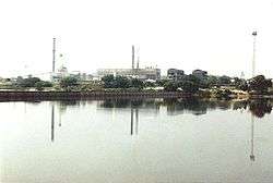
Karur is a city in Indian state of Tamil Nadu.It is in region of Kongunadu. Karur is the administrative headquarters of Karur district. Located on the banks of River Amaravathi, it has been ruled at different times, by the Cheras, Later Cholas, Vijayanagar Empire, Madurai Nayaks, Mysore Kingdom and the British. It is situated at about 420 kilometres (261 mi) southwest of the state capital Chennai.
Etymology
Karur is mentioned in inscriptions and literature by two names, Karuvoor and Vanji. Additionally, it has been referred as: Adipuram, Tiruaanilai, Paupatheechuram, Karuvaippatinam, Vanjularanyam, Garbhapuram, Thiru vithuvakkottam, Bhaskarapuram, Mudivazhangu Viracholapuram, Karapuram, Aadaga maadam, Cherama nagar and Shanmangala Kshetram. Among them, the name Adipuram, meaning the first city seems to indicate that it was held as the foremost city by the medieval writers. It was also called Vanci moothur, the ancient city of Vanji. In the foreign notices of Ptolemy, it was called Karoura - an inland capital of the Cheras.[3]
History
Karur is one of the oldest towns in Tamil Nadu and has played a very significant role in the history and culture of the Tamils. The history dates back to the Sangam period when it was a flourishing trade centre. Karur was built on the banks of river Amaravathi which was called Aanporunai during the Sangam days. According to Hinduism, Brahma began the work of creation here, which is referred to as the "place of the sacred cow."
Epigraphical, archaeological and literary evidence indicate that Karur was the capital of early Chera kings of Sangam age. The names of early Chera kings who ruled from Karur have been found in the rock inscriptions in Aaru Nattar Malai close to Karur. The Tamil epic Silapathikaram mentions that the famous Chera King Senguttuvan ruled from Karur. The archaeological excavations undertaken in Karur resulted in the excavation of mat-designed pottery, bricks, mud-toys, Roman coins, Chera coins, Pallava coins, Roman Amphorae, Rasset coated ware and rare rings.[4] Karur might have been the center for old jewellery-making and gem setting (with the gold imported mainly from Rome), as seen from various excavations. In 150 CE, Greek scholar Ptolemy mentioned "Korevora" (Karur) as a very famous inland trading center in South India.[5] It was ruled by the Cheras, Western Gangas, Cholas, the Vijayanagara Nayaks, Tipu Sultan and the British successively.[3]
Karur municipality was constituted in 1874. It was upgraded to a I grade municipality on 24.10.69, upgraded to selection grade municipality on 24.05.1988, and upgraded to a special grade municipality on 07.04.1988. The city is very expanded now, with 48 wards, much like a city corporation.[6]
Geography and climate
Karur is located at 10°57′N 78°05′E / 10.95°N 78.08°E[7] and has an average elevation of 101 metres (331 feet). The town is located in Karur district of the South Indian state, Tamil Nadu, at a distance of 370 km (230 mi) from Chennai. Karur is located on the banks of Amaravathi river. The topography is almost plain, with no major geological formation. There are no notable mineral resources available in and around the town. The soil types are black and red that are conducive for common crops in the Cauvery delta. The temperature ranges from a maximum of 39 °C (102 °F) to a minimum of 17 °C (63 °F). Like the rest of the state, April to June are the hottest months and December to January are the coldest. Karur receives an average of 590–600 mm (23–24 in) annually, which is lesser than the state average of 1,008 mm (39.7 in). The South west monsoon, with an onset in June and lasting up to August, brings scant rainfall. The bulk of the rainfall comes during the North East monsoon in the months of October, November and December.[3][8]
The prevailing climate in Karur is known as a local steppe climate. According to Köppen and Geiger, this climate is classified as BSh. The average temperature in Karur is 28.7 °C. The average annual rainfall is 590–600 mm. The driest month is March. There is 8 mm of precipitation in March. Most precipitation falls in October, with an average of 166 mm. The precipitation varies 158 mm between the driest month and the wettest month. The average temperatures vary during the year by 5.9°C. With an average of 31.5 °C, May is the warmest month. In December, the average temperature is 25.6°C.
| Climate data for Karur | |||||||||||||
|---|---|---|---|---|---|---|---|---|---|---|---|---|---|
| Month | Jan | Feb | Mar | Apr | May | Jun | Jul | Aug | Sep | Oct | Nov | Dec | Year |
| Average high °C (°F) | 31.1 (88) |
33.7 (92.7) |
36.2 (97.2) |
37.0 (98.6) |
37.1 (98.8) |
35.6 (96.1) |
34.3 (93.7) |
34.2 (93.6) |
33.9 (93) |
32.5 (90.5) |
30.7 (87.3) |
29.4 (84.9) |
33.8 (92.9) |
| Daily mean °C (°F) | 25.8 (78.4) |
27.5 (81.5) |
29.7 (85.5) |
31.3 (88.3) |
31.5 (88.7) |
30.6 (87.1) |
29.6 (85.3) |
29.4 (84.9) |
29.1 (84.4) |
28.1 (82.6) |
26.6 (79.9) |
25.6 (78.1) |
28.7 (83.7) |
| Average low °C (°F) | 20.5 (68.9) |
21.3 (70.3) |
23.2 (73.8) |
25.7 (78.3) |
26.0 (78.8) |
25.6 (78.1) |
24.9 (76.8) |
24.6 (76.3) |
24.3 (75.7) |
23.7 (74.7) |
22.5 (72.5) |
21.8 (71.2) |
23.7 (74.6) |
| Average precipitation mm (inches) | 11.5 (0.453) |
9.2 (0.362) |
8.3 (0.327) |
32.4 (1.276) |
63.5 (2.5) |
17.1 (0.673) |
30.2 (1.189) |
44.6 (1.756) |
63.2 (2.488) |
166.3 (6.547) |
86.3 (3.398) |
61.0 (2.402) |
593.6 (23.371) |
| Average rainy days | 2 | 1 | 1 | 3 | 5 | 2 | 3 | 4 | 6 | 10 | 9 | 6 | 52 |
| Source #1: Climate-Data.org[9] | |||||||||||||
| Source #2: rainy days | |||||||||||||
Demographics
Karur City or Urban Area divided in to Three divisions Karur, Inam karur and Thanthoni Region. Due to population increase. Currently Karur City population has population about 2,34,506. Karur urban area is the 15th biggest city in the state of Tamil Nadu. Karur region has a population of 70,980 with a sex-ratio of 1,032 females for every 1,000 males, much above the national average of 929.[10] A total of 6,147 were under the age of six, constituting 3,162 males and 2,985 females. Scheduled Castes and Scheduled Tribes accounted for 12.11% and .08% of the population respectively. The average literacy of the city was 81.71%, compared to the national average of 72.99%.[10] The city had a total of 49344 households. There were a total of 30,216 workers, comprising 125 cultivators, 181 main agricultural labourers, 469 in house hold industries, 26,660 other workers, 2,781 marginal workers, 24 marginal cultivators, 82 marginal agricultural labourers, 140 marginal workers in household industries and 2,535 other marginal workers.[11] As of 2001, 13 slums were identified in the town.[12] As per the religious census of 2011, Karur (M) had 91.41% Hindus, 5.62% Muslims, 2.88% Christians, 0.01% Sikhs, 0.01% Buddhists, 0.07% following other religions and 0.01% following no religion or did not indicate any religious preference.[13]
The city covers an area of 30.96 square kilometres (11.95 sq mi). More than 8% of the total population of the Karur district and 25% of the total urban population in the district resides in the town. The town has a large floating population. Out of the total area, 86.85% of the land is marked developed and 37.63% of the city remains undeveloped. Residential areas make up 39.41% of the town's total area while commercial enterprises and industrial units make up 4.72% and 1.99% respectively.[14]
The population density of the city in the 2001 census was 128 persons per hectare and the average household size was 3.95 as of 2001. Hindus form the majority of the urban population, followed by Muslims and Christians. Tamil is the main language spoken in the city, but the use of English is relatively common; English is the medium of instruction in most educational institutions and offices in the service sector.[15]
Municipal administration and politics
| Municipality officials | |
|---|---|
| Chairman | M. Selvaraj[16] |
| Commissioner | L. Gopalakrishnan[17] |
| Vice-Chairman | A.R. Kaliyappan[18] |
| Elected members | |
| Member of Legislative Assembly | M.R.Vijaya baskar[19] |
| Member of Parliament | M. Thambi Durai[20] |
Karur is the headquarters of the Karur District. The town was constituted as a municipality in 1874, promoted to first-grade during 1969, selected-grade during 1983 and special-grade as of 1988. The Karur municipality has 48 wards and there is an elected councillor for each of those wards.[21] The functions of the municipality are devolved into six departments: general administration/personnel, Engineering, Revenue, Public Health, city planning and Information Technology (IT). All these departments are under the control of a Municipal Commissioner who is the executive head.[22] The legislative powers are vested in a body of 48 members, one each from the 60 wards.[23] The legislative body is headed by an elected Chairperson assisted by a Deputy Chairperson.[24]
Karur is a part of the Karur assembly constituency and it elects a member to the Tamil Nadu Legislative Assembly once every five years.[25] From the 1977 elections, All India Anna Dravid Munnetra Kazhagam (AIADMK) won the assembly seat five times (in 1977, 1980, 1984, 1991, 2006 and 2011 elections) and two times by Dravida Munnetra Kazhagam (DMK, 1989 and 1996) and Indian National Congress (INC) won once during 2001 elections. The current MLA of Karur constituency is M.R.Vijaya baskar from the ADMK party.[19][26]
Karur is a part of the Karur (Lok Sabha constituency) – it has the following six assembly constituencies – Vedasandur, Aravakurichi, Karur, Krishnarayapuram (SC), Manapparai and Viralimalai state assembly constituencies. The current Member of Parliament from the constituency is A. Thambidurai from the ADMK. From 1957, the Karur parliament seat was held by the Indian National Congress for seven times (during 1957, 1962, 1967, 1971, 1977, 1980 and 1984 elections), ADMK for six times (during 1989, 1991, 1998, 1999, 2009 and 2014 elections), Tamil Maanila Congress once (during 1996 elections) and Dravid Munnetra Kazhagam once (during the 2004 elections). [27][28][29][30][31][32][33][34][35][36][37][38][39] The current Member of Parliament from the constituency is M. Thambi Durai from the ADMK party.[20]
Law & Order
Law and order in the city in maintained by the Karur sub division of the Tamil Nadu Police headed by a Superintendent of Police. There are three police stations in the town. There are special units like prohibition enforcement, district crime, social justice and human rights, district crime records and special branch that operate at the district level police division headed by a Superintendent of Police.[40]
Arts, society and culture

The town formed a part of the traditional Chera and Chola empires and has a number of exquisitely sculpted temples. Karuvurar born in medieval Karur, is one among the nine devotees who sung the divine Music Thiruvichaippa, which is the ninth Thirumurai. He is the single largest composer among the nine authors of Thiruvichaippa. He lived during the reign of the Chola king Raja Raja Chola I. In addition to the Pasupatheeswarar Siva temple, there is a Vishnu temple at Thiruvithuvakkodu suburb of Karur, sung by famous Kulasekaraazhvaar (7th-8th century). The same temple is presumably mentioned in epic Silappadikaram as Adaha maadam Ranganathar whose blessings Cheran Senguttuvan sought before his north Indian expedition.[41][42]
Economy
There are no notable mineral resources available in and around Karur. The town has about 19% of its total area under agricultural land use. The major crops are rice, cotton, sugar cane and oil seeds, while the major horticultural crops are coconut, banana, betel and mango. The town is the commercial centre for trading of agricultural commodities from the nearby towns and villages. Karur, being the headquarters of the district, has registered growth in tertiary sectors, with a corresponding decrease in the primary Sector. Approximately 80 per cent of the workforce is employed in tertiary sector, 17 per cent in primary sector and 4% in secondary sector activities.[43]
Karur is a major home textile centre and has five major product groups — bed linens, kitchen linens, toilet linens, table linens and wall hangings. The town generates around ₹6000 crores in foreign exchange through direct and indirect exports. Allied industries like ginning and spinning mills, dyeing factories and weaving employ around 300,000 people in and around Karur.[44] Hand-loom Exports from Karur began on a modest scale with just 15 exporters in 1975.[43]Karur is also home to an integrated textile park, the ₹130 crore Karur Textile Park Limited (KTPL) a premier facility of its kind in the country for its technical and ancillary facilities.[45]
Bharat Petroleum Corporation formed a joint venture with Petronet CCK and has installed a pipeline facility from Cochin to Karur for transporting petroleum products. The petroleum products received at the BPCL-Karur terminal is supplied to more than 20 districts of Tamil Nadu through container trucks.[46]
TNPL promoted by the Government of Tamil Nadu with loan assistance from the World Bank, located near Karur, is the largest producer of bagasse (sugarcane waste from Sugar mills) based paper in the world and the second largest paper producer in Asia. The firm produces 230,000 tonnes of printing and writing paper and consumes 1 million tonnes of bagasse every year.
Chettinadu group has established a wet process cement plant at Puliyur near Karur with a capacity of 1.7 MTPA.[47]
Karur is a hub for bus body building in South India. The total business turnover from building bus coaches is estimated to be around ₹1000 crore per annum.
About 60% of mosquito nets in India are manufactured in Karur. About 2000 units are engaged in making High-density polyethylene (HDPE) mono filament yarn and associated products and employ about 50,000 people.[48]
Banking
Karur Vysya Bank and Lakshmi Vilas Bank, scheduled private banks, have their headquarters here in Karur. Now it has been nationalised and set up all over India.
Road
The Karur municipality maintains 59.02 km (36.67 mi) of roads. The city has 17.77 km (11.04 mi) concrete roads, 0.53 km (0.33 mi) WBM roads, 0.57 km (0.35 mi) gravel roads and 40.15 km (24.95 mi) bituminous road. A total of 9.51 km (5.91 mi) of state highways is maintained by the State Highways Department and 7 km (4.3 mi) of national highways by the national highways department.[49][50]
There are 2 national highways namely the NH 44 (new numbering) National Highway 7 (India)(old numbering) (Varanasi - Kanyakumari road (now called NSC North-South corridor road NH 44) and NH 67 Nagapattinam - Gudalur road that pass via Karur. The other major state highways connect Karur to Erode, Dharapuram and Mohanur via Vangal.
Karur bus stand is a B-grade bus stand located in the center of the town. The State Express Transport Corporation operates long distance buses connecting the city to important cities like Chennai, Bangalore, Thiruvananthapuram, Thirupathi, Thiruchendur and Thoothukudi.[50][51]
Railway
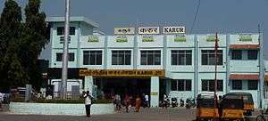
Karur Junction railway station (station code - KRR) is one of the railway junctions under the Salem division of the Indian Railways network. It is one of the major railway station in Southern Railways and also an A grade junction in salem division. Almost All trains to various part of the country halts here except Madurai-Chennai durando express.. It has 5 active Platforms and forms the intersection between Erode-Tiruchirapalli, Erode-Madurai and Salem-Karur-Madurai-Kanyakumari, rail routes.[52][53][54][55]
Airport
The nearest local and international airport is the Tiruchirapalli International Airport, located 78 km away from the town.
Education
As of 2011, there were 32 government schools: 22 elementary schools are here. There were 17 other private schools: ten elementary schools, three middle schools, one higher school and three higher secondary school. There were six engineering colleges, 8 arts and science colleges, three polytechnic colleges and one industrial training institute (ITI) in the town.[56][57]
Utilities
Electricity supply to Karur is regulated and distributed by the Tamil Nadu Electricity Board (TNEB). The town along with its suburbs forms the Karur Electricity Distribution Circle. A Chief Distribution engineer is stationed at the regional headquarters.[58] Water supply is provided by the Karur Municipality from the Cauvery river through Chinnandan Kovil head water work and Thirumanilaiyur water pumping station. In the period 2000–2001, a total of 7 million litres of water was supplied everyday for households in the town.[59]
As per the municipal data for 2011, about 45 metric tonnes of solid waste were collected from Karur every day by door-to-door collection and subsequently the source segregation and dumping was carried out by the sanitary department of the Karur municipality. The coverage of solid waste management in the town by the municipality had an efficiency of 100% as of 2001.[60] There is no underground drainage system in the town and the sewerage system for disposal of sullage is through septic tanks, open drains and public conveniences.[61]
The municipality maintained a total of 115 km (71 mi) of storm water drains in 2011.[62] As of 2011, there is one government hospital, one municipal dispensary, 19 private dispensaries, one ESI dispensary, one municipal Siddha centre, two Ayurvedic clinics, three private general clinics, one private skin care clinic, nine private ENT clinics and one private tuberclosis clinics that take care of the health care needs of the citizens.[63] As of 2011, the municipality maintained a total of 2,584 street lamps: 706 sodium lamps, 151 mercury vapour lamps, 2,274 tube lights and three high mast beam lamp.[64] The municipality operates three markets, namely the Gandhi Market, Kamaraj Market and Uzhavar Santhai that cater to the needs of the town and the rural areas around it.[65]
See also
Notes
- ↑ http://164.100.47.132/LssNew/Members/Biography.aspx?mpsno=3205
- ↑ http://www.assembly.tn.gov.in/members_address_e.pdf
- 1 2 3 Urban Infrastructure Report 2006, p. 4
- ↑ R., Nagaswami (1995). Roman Karur: A peep into Tamil's past. Madras: Brahad Prakashan.
- ↑ "Chera Roman coins". The Hindu. Chennai, India. 4 February 2008. Retrieved 2013-07-07.
- ↑ "About Karur municipality". Karur Municipality. Retrieved 2013-07-07.
- ↑ "Location of Karur". Falling Rain Genomics, Inc - Karur. Retrieved 2013-07-07.
- ↑ "About Karur municipality". Karur Municipality. Retrieved 2013-07-07.
- ↑ "climate: Karur - Climate graph, Temperature graph, Climate table - Climate-Data.org". Climate-Data.org. Retrieved 2015-09-24.
- 1 2 "Census Info 2011 Final population totals". Office of The Registrar General and Census Commissioner, Ministry of Home Affairs, Government of India. 2013. Retrieved 26 Jan 2014.
- ↑ "Census Info 2011 Final population totals - Karur". Office of The Registrar General and Census Commissioner, Ministry of Home Affairs, Government of India. 2013. Retrieved 26 Jan 2014.
- ↑ Urban Infrastructure Report 2008, p. 60
- ↑ "Population By Religious Community - Tamil Nadu" (XLS). Office of The Registrar General and Census Commissioner, Ministry of Home Affairs, Government of India. 2011. Retrieved 13 September 2015.
- ↑ Urban Infrastructure Report 2008, pp. 7-10
- ↑ Urban Infrastructure Report 2008, p. i
- ↑ "Chairman of municipality". Karur municipality. 2011. Retrieved 2012-12-29.
- ↑ "Commissioner of municipality". Karur municipality. 2011. Retrieved 2012-12-29.
- ↑ "Vice Chairman of municipality". Karur municipality. 2011. Retrieved 2012-12-29.
- 1 2 "MLA of Karur". Government of Tamil Nadu. 2011. Retrieved 2012-12-29.
- 1 2 "Members of Lok Sabha from Tamil Nadu". Government of Tamil Nadu. 2014. Retrieved 26 May 2014.
- ↑ "About the municipality". Karur municipality. 2011. Retrieved 2012-12-29.
- ↑ "Commissionerate of Municipal Administration". Commissionerate of Municipal Administration. 2006. Archived from the original on 2012-11-06. Retrieved 2012-12-29.
- ↑ "Councillors of municipality". Karur municipality. 2011. Retrieved 2012-12-29.
- ↑ "Economic and political weekly, Volume 30". Sameeksha Trust. 1995: 2396.
- ↑ "List of Assembly Constituencies". Tamil Nadu. Tamil Nadu state government. 2010. Archived from the original on 2012-06-14. Retrieved 2012-12-28.
- ↑ "Partywise Comparison Since 1977". Election Commission of India. 2011. Retrieved 2012-12-29.
- ↑ "Key highlights of the general elections 1957 to the Second Lok Sabha" (PDF). Election Commission of India. p. 17. Retrieved 2012-12-29.
- ↑ "Key highlights of the general elections 1962 to the Third Lok Sabha" (PDF). Election Commission of India. p. 49. Retrieved 2012-12-29.
- ↑ "Key highlights of the general elections 1967 to the Fourth Lok Sabha" (PDF). Election Commission of India. p. 67. Retrieved 2012-12-29.
- ↑ "Key highlights of the general elections 1971 to the Fifth Lok Sabha" (PDF). Election Commission of India. p. 71. Retrieved 2012-12-29.
- ↑ "Key highlights of the general elections 1977 to the Sixth Lok Sabha" (PDF). Election Commission of India. p. 80. Retrieved 2012-12-29.
- ↑ "Key highlights of the general elections 1980 to the Seventh Lok Sabha" (PDF). Election Commission of India. p. 79. Archived from the original (PDF) on 2014-07-18. Retrieved 2012-12-29.
- ↑ "Key highlights of the general elections 1984 to the Eighth Lok Sabha" (PDF). Election Commission of India. p. 73. Retrieved 2012-12-29.
- ↑ "Key highlights of the general elections 1989 to the Ninth Lok Sabha" (PDF). Election Commission of India. p. 81. Retrieved 2012-12-29.
- ↑ "Key highlights of the general elections 1991 to the Tenth Lok Sabha" (PDF). Election Commission of India. p. 51. Retrieved 2012-12-29.
- ↑ "Key highlights of the general elections 1996 to the Eleventh Lok Sabha" (PDF). Election Commission of India. p. 86. Retrieved 2012-12-29.
- ↑ "Key highlights of the general elections 1998 to the Twelfth Lok Sabha" (PDF). Election Commission of India. p. 85. Retrieved 2012-12-29.
- ↑ "Key highlights of the general elections 1999 to the Thirteenth Lok Sabha" (PDF). Election Commission of India. p. 85. Retrieved 2012-12-29.
- ↑ "Key highlights of the general elections 2004 to the Fourteenth Lok Sabha" (PDF). Election Commission of India. p. 94. Retrieved 2012-12-29.
- ↑ "Karur Police". Karur municipality. 2011. Retrieved 2012-12-29.
- ↑ Iyengar, Mahavidwan R. Raghava (1932) [1918]. Vanjimanagar (University of Madras B.A, Text 1932). University of Madras.
- ↑ Iyengar, Mahavidwan R. Raghava (1932) [1918]. Azhwargal Kaala Nilai on Vithuvakkodu Ranganathar temple. University of Madras.
- 1 2 Urban Infrastructure Report 2008, pp. 11-13
- ↑ "Textile Exports". The Hindu. Chennai, India. 15 November 2005. Retrieved 2005-11-15.
- ↑ "Textile park inaugurated". The Hindu. Chennai, India. 26 February 2011. Retrieved 2013-07-07.
- ↑ "Petronet". BPCL limited. Retrieved 2013-07-07.
- ↑ http://www.chettinad.com/new/cement.php
- ↑ "Power cut situation". The Times of India. 17 October 2012. Retrieved 2013-07-07.
- ↑ "Erode roads". Karur municipality. 2011. Retrieved 2012-12-29.
- 1 2 Urban Infrastructure Report 2008, pp. 20-22
- ↑ "S.E.T.C. Tamil Nadu Ltd., Computer reservation centres". Tamil Nadu State Transport Corporation Ltd. 2011. Retrieved 2012-12-29.
- ↑ "New train flagged off". The Hindu. Chennai, India. 2013-10-02.
- ↑ "Mangalore-Puducherry Express train from this weekend". The Hindu. Chennai, India. 2013-09-27.
- ↑ Renganathan, L. (26 May 2013). "New passenger train chugs into grand reception at Karur junction". The Hindu. Chennai, India. Retrieved 2013-07-01.
- ↑ Renganathan, L. (5 June 2013). "Commuters demand more trains on Salem-Namakkal-Karur.Daily trains to Chennai, Bangalore, Ernakulam and Mysore.And weekly trains to Mumbai, Newdelhi, Jammutawi, Agra cantt, Bhopal and Hydrabad.Karur is one of the 'A' Grade sector junction among 4 stations in salem divisions &its sector.. It is connected with all major cities in india India's important train 'Satabti' express runs via Karur city(only satabti express for Tamil Nadu). Intercity trains to trichy everyday". The Hindu. Chennai, India. Retrieved 2013-07-01.
- ↑ "Educational Institutions". Karur municipality. 2011. Retrieved 2012-12-29.
- ↑ Urban Infrastructure Report 2008, p. 24-25
- ↑ "Important Address" (PDF). Indian Wind Power Association. 2011. Archived from the original (PDF) on 2012-10-16. Retrieved 2012-12-29.
- ↑ "Water Supply Details". Karur Municipality. 2011. Retrieved 2012-12-29.
- ↑ "Waste management programme". Karur Municipality. 2011. Retrieved 2012-12-29.
- ↑ Urban Infrastructure Report 2008, p. 72
- ↑ Urban Infrastructure Report 2008, p. 18
- ↑ Urban Infrastructure Report 2008, p. 25
- ↑ "Karur street lights". Karur Municipality, Government of Tamil Nadu. 2011. Retrieved 2012-12-29.
- ↑ "Karur markets". Karur Municipality, Government of Tamil Nadu. 2011. Retrieved 2012-12-29.
References
- Urban Infrastructure report (2008). Conversion of City Corporate Plan into Business Plan (PDF) (Report). Tamil Nadu Urban Infrastructure Financial Services Limited. Retrieved 2012-12-29.
External links
| Wikivoyage has a travel guide for Karur. |
| State symbols |
|
|---|---|
| Governance |
|
| Topics | |
| Districts |
|
| Major cities | |