Derryginny
Derryginny is a townland in the Parish of Tomregan, Barony of Tullyhaw, County Cavan, Ireland.
Etymology
The townland name is an anglicisation of the Gaelic placename “Doire Goinimhe” which means the ‘Oakwood of the Sand’, which possibly derives either from the sandbanks which form along the rivers running through it or from the large quarry on its northwest boundary. The 1609 Ulster Plantation map spells the name as Dirrigonie[1], the 1652 Commonwealth Survey spells it as Direganny and the 1659 Down Survey map spells it as Derygenny.[2] William Petty's 1685 map spells it as Deregeny.[3] The 1790 Cavan Carvaghs list spells the name as Dirreginny.[4]
Geography
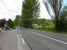
It is bounded on the north by Doon, Tomregan and Gortoorlan townlands, on the west by Snugborough and Carrowmore, County Cavan townlands, on the south by Lecharrownahone townland and on the east by Cullyleenan townland. Its chief geographical features are the Shannon-Erne Waterway which flows north along its eastern boundary, the Crooked River (Ireland), the Tanyard Stream which exits into the canal beside Ballyconnell Bridge and a central drumlin hill of blue sandy clay which rises over 200 feet above sea level. Derryginny is traversed by Church Street, Bridge Street, the N87 road (Ireland), the R205 road (Ireland), Derryginny lane, Carrowmore lane and by the disused Cavan & Leitrim Railway. The townland covers 126 statute acres, including three acres of water.
History
It formed part of the Manor of Calva which was granted to Walter Talbot in 1610 as part of the Plantation of Ulster. The 1652 Commonwealth Survey lists the townland as belonging to Captain Gwilliams (i.e. the landlord of Ballyconnell, Captain Thomas Gwyllym). The only recorded inhabitant of the townland in the 1664 Hearth Money Rolls was Richard Harrison.
The Tithe Applotment Books for 1827 list the following tithepayers in the townland- Moore, Sturdy, Netterfield, Flood, Gwynne, Hannon, Cochrane.[5]
The Ordnance Survey Name Books for 1836 give the following description of the townland- Doire gainimhe, 'oak wood of the sand'. Centre of parish. Property of Montgomery. Rent £2 per arable acre. Soil is blue sandy clay. A good road South to West. A limestone quarry.
The 1841 Census of Ireland gives a population of 44 in Derryginny, of which 18 were males and 26 were females, with 8 houses.
The 1851 Census of Ireland gives a population of 30, a decrease of 14 on the 1841 figure, due to the intervening Irish Famine of 1845–47, of which 13 were males and 17 were females, with 8 houses.
Griffith’s Valuation of 1857 lists the landlords of the townland as Magee and Netterfield and the tenants as Gwynne, Graham, Schoolhouse, Small, Kells, Netterfield, Donohoe, Caffrey, Wilson and Hannon.[6]
In 1861 the population of the townland was 39, being 17 males and 22 females. There were ten houses in the townland, all were inhabited.[7]
In 1871 the population of the townland was 23, being 13 males and 10 females. There were eight houses in the townland, of which two were uninhabited (page 297 of census).[8]
In 1881 the population of the townland was 24, being 11 males and 13 females. There were six houses in the townland, all were inhabited.[9]
In 1891 the population of the townland was 17, being 7 males and 10 females. There were five houses in the townland, all were inhabited.[10]
In the 1901 census of Ireland, there are six families listed in the townland, apart from those on the Derryginny side of Church Street.[11]
In the 1911 census of Ireland, there were six families in the townland, apart from those on the Derryginny side of Church Street.[12]
In 2017 an award-winning documentary was made about a Derryginny farmer, 85 year-old Raymond Ovens.[13]
Derryginny School
In the Dúchas Schools' Collection at [14] is an account of Derryginny Tanyard School of the 1800s.
Antiquities
The chief buildings of historical interest are Tomregan Parish Hall (erected in 1949), Tomregan Church of Ireland School (originally built in 1820 and rebuilt in 1967), Tomregan Masonic Hall (erected in 1911),[15] Ballyconnell Bridge , the railway Red Bridge (erected in 1887) and Rose Bank House (a Georgian house built in 1812 as a rectory.[16] [17]). Two former buildings were the Star Ballroom (opened on 11 February 1949) and the Tannery. Derryginny’s chief claim to fame is that it is the location of the ford at which the Ulster hero Conall Cernach was killed and from which the town of Ballyconnell was named.
