Cranaghan
Cranaghan is a townland in the Parish of Tomregan, Barony of Loughtee Lower, County Cavan, Ireland.
Etymology
The townland name is an anglicisation of the Gaelic placename Crannachan which means ‘Woodland’. The earliest surviving mention of the townland is on the 1609 Ulster Plantation map of the Barony of Loughtee, where it is spelled Granchinah.
Geography
It is bounded on the north by Killywilly townland, on the east by Ardue, Ture and Greaghrahan townlands, on the south by Aghavoher and Carrigan townlands and on the west by Cavanagh (townland) and Mullaghduff townlands. Its chief geographical features are Killywilly Lough, Agavoher Lough, Lough Rud, the Rag River and several small drumlin hills reaching to an altitude of 250 feet above sea-level. Cranaghan is traversed by the N87 road (Ireland) and some minor lanes. The townland covers 492 acres, including 108 acres of water.
History
In a grant of the Manor of Monaghan dated 21 June 1610 from King James I to Sir Hugh Wyrral, it is specified that the two polls of Granchinagh containing 90 acres are excepted from this grant.
The Tithe Applotment Books for 1827 list the following tithepayers in the townland- Kane, Reilly, Story, Green, Taylor, Brady, Dolan, McGauran, Laurence, Shewell, Corry, Ross, Gillon, McIlroy, Rooney. [1]
In 1829 a Sunday school was kept in the townland, funded by the Hibernian Sunday School Society.[2]
The Ordnance Survey Name Books for 1836 give the following description of the townland-Crannachan, 'wood-land'. It lies in the East of the parish. This is glebe land. The residence of the Revd J. Story is a neat building with a garden plantation. Rent is 25 shillings per arable acre. Soil is gravelly. Produce is oats, flax and potatoes. There is a large limestone quarry in the land, much used for building and agricultural purposes. Cranaghan Glebe House is the residence of Reverend Story. It has planting and a good garden. In good repair.[3]
In 1841 the population of the townland was 211, being 94 males and 117 females. There were thirty-nine houses in the townland, of which four were uninhabited.[4]
In 1851 the population of the townland was 126, being 64 males and 62 females, the reduction being due to the Great Famine (Ireland). There were twenty-five houses in the townland, of which three were uninhabited.[5]
Griffith's Valuation of 1857 lists thirty-eight occupiers in the townland.[6]
In 1861 the population of the townland was 116, being 54 males and 62 females. There were twenty-five houses in the townland, one of which was uninhabited.[7]
In 1871 the population of the townland was 118, being 58 males and 62 females. There were twenty-five houses in the townland, all were inhabited (page 279 of census).[8]
In 1881 the population of the townland was 120, being 56 males and 64 females. There were twenty-four houses in the townland, all were inhabited.[9]
In 1891 the population of the townland was 102, being 51 males and 51 females. There were twenty-four houses in the townland, of which two were uninhabited.[10]
In the 1901 census of Ireland, there are twenty-eight families listed in the townland.[11]
In the 1911 census of Ireland, there are twenty-six families listed in the townland.[12]
In the Dúchas Schools' Collection at [13] Mrs Reilly in 1938 relates a treasure story that occurred in Cranaghan.
Antiquities
- A prehistoric wedge tomb which was originally located in Aughrim townland but was excavated in 1992 and moved to the grounds of the Slieve Russell hotel due to quarrying operations, (Site number 7, page 2, Aughrim townland, in Archaeological Inventory of County Cavan, Patrick O’Donovan, 1995). It was one of only two megalithic structures in Tomregan parish; the only one now remaining in situ is the court-cairn in Doon townland.[14]
- A medieval crannóg in Killywilly Lough (Site number 1515, page 181, Cranaghan townland, in Archaeological Inventory of County Cavan, Patrick O’Donovan, 1995). Among the objects found in the crannog were a bronze socketed axe.[15]
- An Orange Hall
- Cranaghan Bridge.
- Cranaghan Hedge School. Run in the early 19th century with the support of the Kildare Place Society by a Roman Catholic teacher called Francis Carney in a field owned by Mr. Patterson. The teacher was paid at Christmas each year by the schoolchildren. It was a thatched school with three windows on one side and a door on the other. The fire fuel of turf and wood was kept in a small room off the schoolroom, each child bringing a sod of turf with them each day. There were wooden desks with inkwells. The teacher lived on his own small farm. There was a total of 129 pupils, 79 boys and 50 girls.[16]
- In the 19th and early 20th centuries Cranaghan had one of the biggest lime-kiln industries in County Cavan, run by the O’Reilly family.
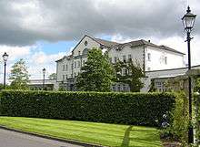
- The Slieve Russell hotel and golf course now stand on the site of Cranaghan House which was the Church of Ireland rectory for Tomregan parish from 1850 to 1959.
References
- ↑ "The Tithe Applotment Books, 1823-37". Titheapplotmentbooks.nationalarchives.ie. Retrieved 2016-01-25.
- ↑
- ↑ Cranaghan(English) (2015-11-03). "Cranaghan". Logainm.ie. Retrieved 2016-01-25.
- ↑
- ↑
- ↑ "Griffith's Valuation". Askaboutireland.ie. Retrieved 2016-01-25.
- ↑
- ↑
- ↑
- ↑
- ↑ "National Archives: Census of Ireland 1901". Census.nationalarchives.ie. Retrieved 2016-01-25.
- ↑ "National Archives: Census of Ireland 1911". Census.nationalarchives.ie. Retrieved 2016-01-25.
- ↑
- ↑
- ↑ George Eogan. "The Socketed Bronze Axes in Ireland". Books.google.co.uk. p. 141. Retrieved 2016-01-25.
- ↑
