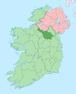
Toberlyan
Toberlyan (from Irish: usually given as Tobar Laighin, meaning either 'St Leynie's Well' or "The Well of the Spear" but probably more correctly Tobar Lann, meaning the 'Well of the Church') is a townland in the civil parish of Templeport, County Cavan, Ireland. It lies in the Roman Catholic parish of Templeport and barony of Tullyhaw.
Geography
Toberlyan is bounded on the north by Corran townland, on the west by Derrycassan townland, on the south by Coologe townland and on the east by Toberlyan Duffin townland. Its chief geographical features are Coologe Lough, a stream and a stone quarry. Toberlyan is traversed by minor roads and rural lanes.
The townland covers 172 statute acres.[1]
History
Until the Cromwellian Act for the Settlement of Ireland 1652, Toberlyan formed part of the modern townland of Coologe, as one of its subdivisions. Therefore Toberlyan is not depicted on the 1609 Baronial or 1665 Down Survey maps or appears in the land grants before 1652.
The McGovern lands in Coologe were confiscated in the Cromwellian Act for the Settlement of Ireland 1652 and the Toberlyan land was distributed as follows-
The 1652 Commonwealth Survey lists the name as Toberleyen and the proprietor as Brian MacGillebreeda and the tenant as Hugh McSweene.
A grant dated 30 January 1668 from King Charles II to Maurice McJelbredy included one pole in Tubenleene.
The 1790 Cavan Carvaghs list spells the name as Tobberlyan.[2]
In the 1825 Registry of Freeholders for County Cavan there was one freeholder registered in Tobberlyan- John Dunn. He was a Forty-shilling freeholders holding a lease for lives from his landlord, Mr. R. Hinds.
The Tithe Applotment Books for 1827 list forty eight tithepayers in the townland.[3]
In 1841 the population of the townland was 121, being 64 males and 57 females. There were twenty houses in the townland, all were inhabited.[4]
In 1851 the population of the townland was 93, being 50 males and 43 females, the reduction being due to the Great Famine (Ireland). There were nineteen houses in the townland, all inhabited.[5]
Griffith's Valuation of 1857 lists fourteen landholders in the townland.[6]
In 1861 the population of the townland was 38, being 22 males and 16 females. There were seven houses in the townland and all were inhabited.[7]
In 1871 the population of the townland was 62, being 26 males and 36 females. There were thirteen houses in the townland and all were inhabited.(page 296 of census)[8]
In 1881 the population of the townland was 46, being 25 males and 21 females. There were ten houses in the townland, all were inhabited.[9]
In 1891 the population of the townland was 49, being 23 males and 26 females. There were nine houses in the townland, all were inhabited.[10]
In the 1901 census of Ireland, there are five families listed in the townland.[11]
In the 1911 census of Ireland, there are five families listed in the townland.[12]
Antiquities
References
- ↑ "IreAtlas". Retrieved 29 February 2012.
- ↑
- ↑ Tithe Applotment Books 1827
- ↑
- ↑
- ↑ - Toberlyan
- ↑
- ↑
- ↑
- ↑
- ↑ Census of Ireland 1901
- ↑ Census of Ireland 1911
- ↑ Site numbers 90 and 91 in “Archaeological Inventory of County Cavan”, Patrick O’Donovan, 1995
- 1 2 3
- ↑ Site number 118 in “Archaeological Inventory of County Cavan”, Patrick O’Donovan, 1995
