Cullyleenan
Cullyleenan is a townland in the Parish of Tomregan, Barony of Tullyhaw, County Cavan, Ireland.
Etymology
The townland name is an anglicisation of the Gaelic placename ‘Coill Uí Lionáin’ which means “O’Lenan’s Wood”, which possibly belonged to a member of the Uí Lionán family who were a bardic family from County Fermanagh. Alternative meanings that have been suggested are ‘Wood of the Fishing-bank’ or ‘Wood of the Gorge’. The 1609 Ulster Plantation map spells the name as Colelenan.[1] The 1652 Commonwealth Survey spells it as Coolelenan and the 1659 Down Survey map spells it as Colelolan.[2] William Petty's 1685 map spells it as Cololan.[3] The 1790 Cavan Carvaghs list spells the name as Cullelinan.[4]
Geography
It is bounded on the north by Annagh townland, on the west by Derryginny townland, on the south by Agharaskilly townland and on the east by Mullaghduff townland. Its chief geographical features are the Shannon-Erne Waterway which flows north along its western boundary and a central drumlin hill which rises over 200 feet above sea level. Cullyleenan is traversed by Bridge Street, the N87 road (Ireland), the Agharaskilly road, the Chapel Road and by the disused Cavan & Leitrim Railway. The townland covers 62 statute acres, including two acres of water.
History
It formed part of the Manor of Calva which was granted to Walter Talbot in 1610 as part of the Plantation of Ulster. The 1652 Commonwealth Survey lists the townland as belonging to Captain Gwilliams (i.e. the landlord of Ballyconnell, Captain Thomas Gwyllym).
The Tithe Applotment Books for 1827 list the following tithepayers in the townland- Keon, Grimes, Wynne, Clark, McLaughlin, Sturdy, Hanna, Donahy, Montgomery, Answell, Reilly, Brady, Sheridan, McGraugh, Benison, Gallagher, Murdy, Enery.[5]
In 1829 a Sunday school was kept in the townland, funded by the Hibernian Sunday School Society.[6]
The Ordnance Survey Name Books for 1836 give the following description of the townland- Coill Uí Lionáin, 'O'Lenen's wood'. South of Ballyconnell. Property of Montgomery. Rent £2 per arable acre. 10 acres of bog and 8 acres of pasture, the rest is arable land. It contains a bit of the town of Ballyconnell, the Roman Catholic church and several good roads.
The 1841 Census of Ireland gives a population of 220 in Cullyleenan, of which 105 were males and 115 were females, with 40 houses, of which two were uninhabited.
The 1851 Census of Ireland gives a population of 164, a decrease of 56 on the 1841 figure, due to the intervening Irish Famine of 1845–47, of which 80 were males and 84 were females, with 30 houses, of which three were uninhabited.
Griffith's Valuation of 1857 lists the landlords of the townland as Kane, Webb and Wilson and the tenants as Webb, McDermott, Donohoe, Rourke, Brady, Reilly, Maguire, McGaghran, Kelly, Flynn, Sullivan, Kane, Griffin, Roe, Gallaher, Roman Catholic Chapel, Gileese, Benson, Thompson and Wilson. Further information and a detailed map showing the location of each holding can be seen online.[7]
In 1861 the population of the townland was 90, being 43 males and 47 females. There were twenty-one houses in the townland, one of which was uninhabited.[8]
In 1871 the population of the townland was 58, being 30 males and 28 females. There were nineteen houses in the townland, all were inhabited (page 297 of census).[9]
In 1881 the population of the townland was 65, being 26 males and 39 females. There were eighteen houses in the townland, one of which was uninhabited.[10]
In 1891 the population of the townland was 47, being 23 males and 24 females. There were sixteen houses in the townland, of which two were uninhabited.[11]
In the 1901 census of Ireland, there are thirteen families listed in the townland.[12]
In the 1911 census of Ireland, there are fourteen families listed in the townland. The high population is because part of the town of Ballyconnell is situate in Cullyleenan.[13]
In the Dúchas School's Collection at [14] a story by Miss Yeates, The Courthouse, Ballyconnell in 1938 relates a ghost story that occurred on Daisy Hill in Cullyleenan.
Antiquities
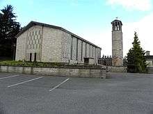
The chief buildings of historical interest are Our Lady of Lourdes R.C. Church (opened on 25 August 1968),[15] Ballyconnell New School (opened September 1968),[16] the disused St.Brigid’s Roman Catholic church and graveyard (erected in 1843 on the site of a Mass-house erected c.1780)),[17] the Parochial House (erected c.1875), the Interdenominational graveyard (opened in 1980’s), the former Railway Station (opened 24 October 1887, finally closed on 1 April 1959),[18] Ballyconnell Bridge which was erected in the 1830s [19], the railway Red Bridge (erected in 1887) and an early-medieval ringfort (Site number 489, page 70, Cullyleenan townland, in “Archaeological Inventory of County Cavan”, Patrick O’Donovan, 1995). Two former buildings were the Star Plastics factory (opened in 1962) and Ballyconnell Creamery (opened 1902, closed 1947).
