Tonyrevan
Tonyrevan (from Irish: either Tonnaigh Riabhain, meaning 'The Pasture of the Grey Hill' or Tonnaigh Craobhach, meaning 'The Bushy Pasture' or Tonnaigh Riabháin, meaning "Revan's Pasture") is a townland in the civil parish of Templeport, County Cavan, Ireland. It lies in the Roman Catholic parish of Templeport and barony of Tullyhaw.
Geography
Tonyrevan is bounded on the west by Tonyhallagh and Killycluggin townlands, on the east by Crossmakelagher townland and on the south by Bellaheady townland in Kildallan parish. Tonyrevan's chief geographical features are a wood, a spring well, a dug well and a stone quarry.[1]
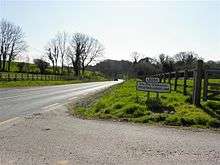
Tonyrevan is traversed by the national secondary R205 road (Ireland), rural lanes and the disused Cavan and Leitrim Railway.[2]
The townland covers 55 statute acres.[3]
History
The 1609 Baronial Map depicts the townland as part of Killcloggin (now the modern townland of Killycluggin).[4] [5]
The 1652 Commonwealth Survey spells the name as Tonyreavan.
The 1665 Down Survey map depicts it as Tonyrevan.[6]
Another name for the townland was Rostonibeg (from Irish: Ros Tonnaigh Beag, meaning 'The Wood of the Small Pasture')
The 1652 Commonwealth Survey lists the proprietor as being Lieutenant John Blackforde and the tenant as Dorby Donn, who also appear as proprietor and tenant for several other Templeport townlands in the same survey. John Blachford was born in 1598 in Ashmore, Dorset, England, the son of Richard and Frances Blachford. He became a merchant in Dorchester, Dorset but fled to France in 1633 when facing a warrant from the Exchequer for not paying customs. He married Mary Renald from Devon and died at Lissanover, County Cavan in 1661 and was buried at St. Orvins in Dublin despite wishing to be buried back in Dorchester. His will was published on 9 January 1665 leaving his son John Blachford as his sole heir. An Inquisition held in Cavan on 21 May 1667 found that his widow Mary Blachford and his heir John were seized of, inter alia, the land of Toneycrevagh alias Townegrevan alias Toneyrevan. He had sons John, Thomas, Ambrose and William (who became a Major) and daughters Mary and Frances. Major William Blachford was born in 1658 and died at Lissanover on 28 March 1727. The Blachford family gravestones in Templeport Church read as follows- This monument was erected by MAJOR WILLIAM / BLASHFORD of Lisnover in 1721 to the memory of / his father, JOHN BLASHFORD, late of the same Esqr. but / from Dorchester in Dorsetshire, the place of his / nativity, who in his lifetime chose this for a burying / place, for himself and family, but died in Dublin / was buried in St. Orvins Church but his wife, MARY / RENALD of a Devonsheire family is buried here / as also three sons and two daughters, viz JOHN / AMBROSE AND THOMAS; MARY AND FRANCES / Here likewise lies buried two wives of MAJOR WILLIAM BLASHFORD, son to the said JOHN BLASHFORD viz / MARY MAGHEE of an ancient Family in Lincolnsheire. CORNET CHIDLEY BLACHFORD, son to MAJOR WILLIAM BLACHFORD, leys buried here who dyed August ye 29th, 1722. This aboue MAJOR WILLIAM BLACHFORD. / That erected this monument, died the 28th of March 1727, aged 69 years.
The 1790 Cavan Carvaghs list spells the name as Tonnyrevan.[7]
The Tithe Applotment Books for 1827 list eight tithepayers in the townland.[8]
In 1841 the population of the townland was 21, being 10 males and 11 females. There were four houses in the townland, all were inhabited.[9]
In 1851 the population of the townland was 18, being 9 males and 9 females, the reduction being due to the Great Famine (Ireland). There were three houses in the townland, all inhabited.[10]
Griffith's Valuation of 1857 lists four landholders in the townland.[11]
In 1861 the population of the townland was 12, being 4 males and 8 females. There were two houses in the townland and all were inhabited.[12]
In 1871 the population of the townland was 12, being 5 males and 7 females. There were two houses in the townland and all were inhabited.(page 296 of census)[13]
In 1881 the population of the townland was 10, being 4 males and 6 females. There were two houses in the townland, all were inhabited.[14]
In 1891 the population of the townland was 9, being 3 males and 6 females. There were two houses in the townland, all were inhabited.[15]
In the 1901 census of Ireland, there are two families listed in the townland,[16] and in the 1911 census of Ireland, there are two families listed in the townland.[17]
References
- ↑ "25 Inch Ireland Ordnance Survey Map".
- ↑ "25 Inch Ireland Ordnance Survey Map".
- ↑ "IreAtlas". Retrieved 29 February 2012.
- ↑ National Archives Dublin:
- ↑
- ↑ Trinity College Dublin: The Down Survey of Ireland.
- ↑
- ↑ and , in the Tithe Applotment Books 1827
- ↑
- ↑
- ↑ "Griffith's Valuation".
- ↑
- ↑
- ↑
- ↑
- ↑ "National Archives: Census of Ireland 1901".
- ↑ "National Archives: Census of Ireland 1911".
External links
