Brackley, Templeport
Brackley (from Irish: Breac Loch meaning 'Speckled Lake' or less likely Breaclaí meaning "Speckled Land") is a townland in the civil parish of Templeport, County Cavan, Ireland. It lies in the Roman Catholic parish of Templeport and barony of Tullyhaw.
Geography
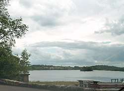
Brackley is bounded on the north by Mullaghlea townland, on the west by Prospect, Corlough parish and Derrymony townlands, on the south by Killyneary, Carrick East and Gortnavreeghan townlands and on the east by Mullanacre Upper townland in Tomregan parish. Its chief geographical features are Slieve Rushen mountain on whose western slope it lies, Brackley Lough, mountain streams, mountain bogs, Brackley Wood, forestry plantations, stone quarries and dug wells. It forms part of the Slieve Rushen Bog Natural Heritage Area An island in Brackley Lough is called the Baron's Island after a Baron de Trent who lived in Brackley House c.1850 and who built a studio on the island. Brackley is traversed by the regional N87 road (Ireland) and rural lanes. The townland covers 619 statute acres.[1]
History
The 1609 Baronial Map depicts the townland as Brockl.[2]
The 1652 Commonwealth Survey lists the townland as Bracklagh.
The 1665 Down Survey map depicts the townland as Bracklogh.[3]
William Petty's 1685 map depicts it as Bracklough.
On 12 November 1590 Queen Elizabeth I of England granted a pardon (No. 5489) to Ferrall M'Gawran of Breachlaghe, gentleman for fighting against the Queen's forces.[4] He was probably the same man who had already been pardoned on 19 January 1586 (No. 4813, Ferriell M'Manus M'Thomas Magawran of Killsollaghe), so he was still fighting against the English three years later. The said Farrell McGovern was the grandson of Tomas Mág Samhradháin who was chief of the McGovern Clan from 1512 to 1532.
In the Plantation of Ulster by grant dated 26 June 1615, King James VI and I granted, inter alia, two polls in Bracklee to Sir George Graeme and Sir Richard Graeme to form part of the Manor of Greame. An Inquisition held at Cavan Town on 31 October 1627 found that George Greames was seized of one poll in Brackley and he died 9 October 1624. By his will dated 1 May 1615 he left his lands to his son and heir William Greames then 30 years old (born 1594) and unmarried.
The 1652 Commonwealth Survey lists the proprietor as being Mr Thomas Worsopp and the tenant being William Lawther, both of whom appear as proprietor and tenant for several other Templeport townlands in the same survey.
The 1662 Hearth Money Rolls show three Hearth Tax payers in Bracklagh- Hugh McBrien, Phelemy McBrien and Farrall McBrien.
In the Templeport Poll Book of 1761 there were only three people registered to vote in Brockly in the Irish general election, 1761[5] - Francis Dowler, John Dowler and John McGee. They were entitled to two votes each. The Dowlers both voted for Lord Newtownbutler (later Brinsley Butler, 2nd Earl of Lanesborough) who was elected Member of Parliament for Cavan County and for George Montgomery (MP) of Ballyconnell, who lost the election. McGee voted for Lord Newtownbutler (later Brinsley Butler, 2nd Earl of Lanesborough) who was elected Member of Parliament for Cavan County and for Barry Maxwell, 1st Earl of Farnham, who lost the election. Absence from the poll book either meant a resident did not vote or more likely was not a freeholder entitled to vote, which would mean most of the inhabitants of Brackley.
The 1790 Cavan Carvaghs list spells the townland name as Bracklagh.[6]
In the 1825 Registry of Freeholders for County Cavan there was one freeholder registered in Brackley- Michael Cassidy. He was a Forty-shilling freeholders holding a lease for lives from his landlord, Francis Finley.
The Tithe Applotment Books for 1827 list nineteen tithepayers in the townland.[7]
In 1833 two people in Brackley were registered as a keeper of weapons- Charles Carson and Launcelott Fiffe.[8]
In 1841 the population of the townland was 170, being 90 males and 80 females. There were thirty-one houses in the townland, of which two were uninhabited.[9]
In 1851 the population of the townland was 132, being 72 males and 60 females, the reduction being due to the Great Famine (Ireland). There were twenty-four houses in the townland, of which all were inhabited.[10]
Griffith's Valuation of 1857 lists thirty nine landholders in the townland.[11]
In 1861 the population of the townland was 122, being 66 males and 56 females. There were twenty houses in the townland and all were inhabited.[12]
In 1871 the population of the townland was 83, being 48 males and 35 females. There were eighteen houses in the townland, all were inhabited.[13]
In 1881 the population of the townland was 84, being 44 males and 40 females. There were twenty houses in the townland, of which four were uninhabited.[14]
In 1891 the population of the townland was 70, being 38 males and 32 females. There were fourteen houses in the townland, one of which was uninhabited.[15]
In the 1901 census of Ireland, there are fourteen families listed in the townland, [16] and in the 1911 census of Ireland, there are thirteen families listed in the townland.[17]
On 12 June 1921, Dean John Finlay, a 78 year old Protestant clergyman, was shot dead in an IRA raid on his home at Brackley House.
Brackley School
Brackley School was actually located in the townland of Mullaghlea, not Brackley.
Antiquities
The chief structures of historical interest in the townland are:
References
- ↑ "IreAtlas". Retrieved 29 February 2012.
- ↑ National Archives Dublin
- ↑ Trinity College Dublin: The Down Survey of Ireland.
- ↑
- ↑
- ↑
- ↑ and and
- ↑
- ↑
- ↑
- ↑
- ↑
- ↑
- ↑
- ↑
- ↑
- ↑ Census of Ireland 1911
- ↑ Site number 264 in "Archaeological Inventory of County Cavan", Patrick O’Donovan, 1995
- ↑ http://www.templeport.ie/magh-slecht-dara-fort/plain-of-blood.pdf
External links
