Corrachomera
Corrachomera (from Irish: Currach Iomaire, meaning "The Marshy Ridge") is a townland in the civil parish of Templeport, County Cavan, Ireland. It lies in the Roman Catholic parish of Corlough and barony of Tullyhaw.[1] The local pronunciation is Currach-Humra.
Geography
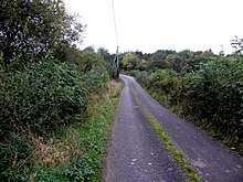
Corrachomera is bounded on the north by Owencam and Tullywaum townlands, on the west by Tullyveela and Tullynaconspod townlands, on the south by Cartronnagilta and Greaghnadoony townlands and on the east by Corlough townland, Leitra, Corlough and Tullytrasna townlands. Its chief geographical features are mountain streams, forestry plantations, gravel pits, dug wells and spring wells. Corrachomera is traversed by minor public roads and rural lanes. The townland covers 337 statute acres.[2]
History
In earlier times the townland was probably uninhabited as it consists mainly of bog and poor clay soils. It was not seized by the English during the Plantation of Ulster in 1610 or in the Cromwellian Settlement of the 1660s so some dispossessed Irish families moved there and began to clear and farm the land.
A map of the townland drawn in 1813 is in the National Archives of Ireland, Beresford Estate Maps, depicts the townland as Curraghcombera or Curcanderry (The Marsh of the Oakwood) and the owners as John Finlay and George Finlay and the previous owner as Colonel Ennery deceased.
The Tithe Applotment Books for 1826 list one hundred and eighty five tithepayers in the townland.[3]
The Ordnance Survey Name Books for 1836 give the following description of the townland- The townland is bounded on the S. side by a large mountain stream.
In 1841 the population of the townland was 138, being 62 males and 76 females. There were twenty-six houses in the townland, all of which were inhabited.[4]
In 1851 the population of the townland was 122, being 64 males and 58 females, the reduction being due to the Great Famine (Ireland). There were twenty-two houses in the townland, two of which were uninhabited.[5]
Griffith's Valuation of 1857 lists thirty eight landholders in the townland.[6]
In 1861 the population of the townland was 118, being 54 males and 64 females. There were twenty-two houses in the townland, of which one was uninhabited.[7]
In the 1901 census of Ireland, there are twenty seven families listed in the townland.[8]
In the 1911 census of Ireland, there are twenty seven families listed in the townland.[9]
Antiquities
- Lime-kilns
- Stepping stones over the river
