Doon (Tomregan)

The townland of Doon in the civil parish of Tomregan is in the electoral district of Ballyconnell. It is also situated in the barony of Tullyhaw.[1]
Geography
Doon is bounded on the north by Mucklagh & Rakeelan townlands, on the east by Annagh townland, on the south by Derryginny townland and on the west by Gortoorlan townland. Its chief geographical features are the Shannon-Erne Waterway and some drumlin hills reaching an altitude of 200 feet (61 m) above sea-level. The major part of Ballyconnell town is situated in Doon and the townland is traversed by the N87 road (Ireland), the R205 road (Ireland), the L1063 road, Church Street, Main Street, Bridge Street, Preaching House Lane, Mucklagh Lane and the Border Road. The townland covers 125 statute acres, including 4 acres (16,000 m2) of water.
History
The 1609 Ulster Plantation map spells the name as Doone and a sub-division as Tennegh.[2] Doon formed part of the Manor of Calva which was granted to Walter Talbot in 1610 as part of the Plantation of Ulster. The 1652 Commonwealth Survey lists the townland (including the subdivision called Tennagh or Tionagh) as belonging to Captain Gwilliams (i.e. the landlord of Ballyconnell, Captain Thomas Gwyllym) and the tenant as Robert Worvell. The Hearth Money Rolls of 1664 list the occupiers of Ballyconnell as Thomas Gwyllym, John Squire, Henry Jordan and Denis Alarne, but this would have included both Doon and Annagh townlands as Thomas Gwyllym was the owner of Ballyconnell Castle and lived in Annagh. The 1659 Down Survey map spells it as Downe.[3] William Petty's 1685 map spells it as Downe.[4] The 1790 Cavan Carvaghs list spells the name as Doon and Ennagh.[5]
The Tithe Applotment Books for 1827 list forty-seven tithepayers in the townland.[6]
In 1832 one person in Doon was registered as a keeper of weapons- Ralph Montgomery, who had one gun, one pistol and two swords.[7]
The Ordnance Survey Name Books for 1836 give the following description of the townland- Dún, 'a fort'. Property of Montgomery. The town of Ballyconnell sits in this townland. The town is held by leases of lives. A weekly market on Friday and a monthly fair is held on the first Monday of every month. There is a church and jail, and post office, a corn mill & bleach green
The 1841 Census of Ireland gives a combined population of 671 for Doon and Ballyconnell, of which 333 were males and 338 were females, with 127 houses, of which 12 were uninhabited.
The 1851 Census of Ireland gives a combined population of 667, a decrease of 4 on the 1841 figure, due to the intervening Irish Famine of 1845–47, of which 331 were males and 336 were females, with 119 houses, of which 7 were uninhabited. The decrease was minimal compared to other townlands, due to work being available in the town.
Griffith's Valuation of 1857 lists about 90 landlords and tenants for Doon and Ballyconnell. [1]
In 1861 the population of the townland was 123, being 55 males and 68 females. There were thirty houses in the townland, of which two were uninhabited and one in the course of erection.[8]
In 1871 the population of the townland and number of houses were included within the census figures for the town of Ballyconnell.
In 1881 the population of the townland and number of houses were included within the census figures for the town of Ballyconnell.
In 1891 the population of the townland was 65, being 28 males and 37 females. There were twenty houses in the townland, of which two were uninhabited.[9]
In the 1901 census of Ireland, there are over a hundred families listed in the townland. [10][11]
In the 1911 census of Ireland, there are over 100 families listed in the townland and in Ballyconnell.[12][13]
Antiquities
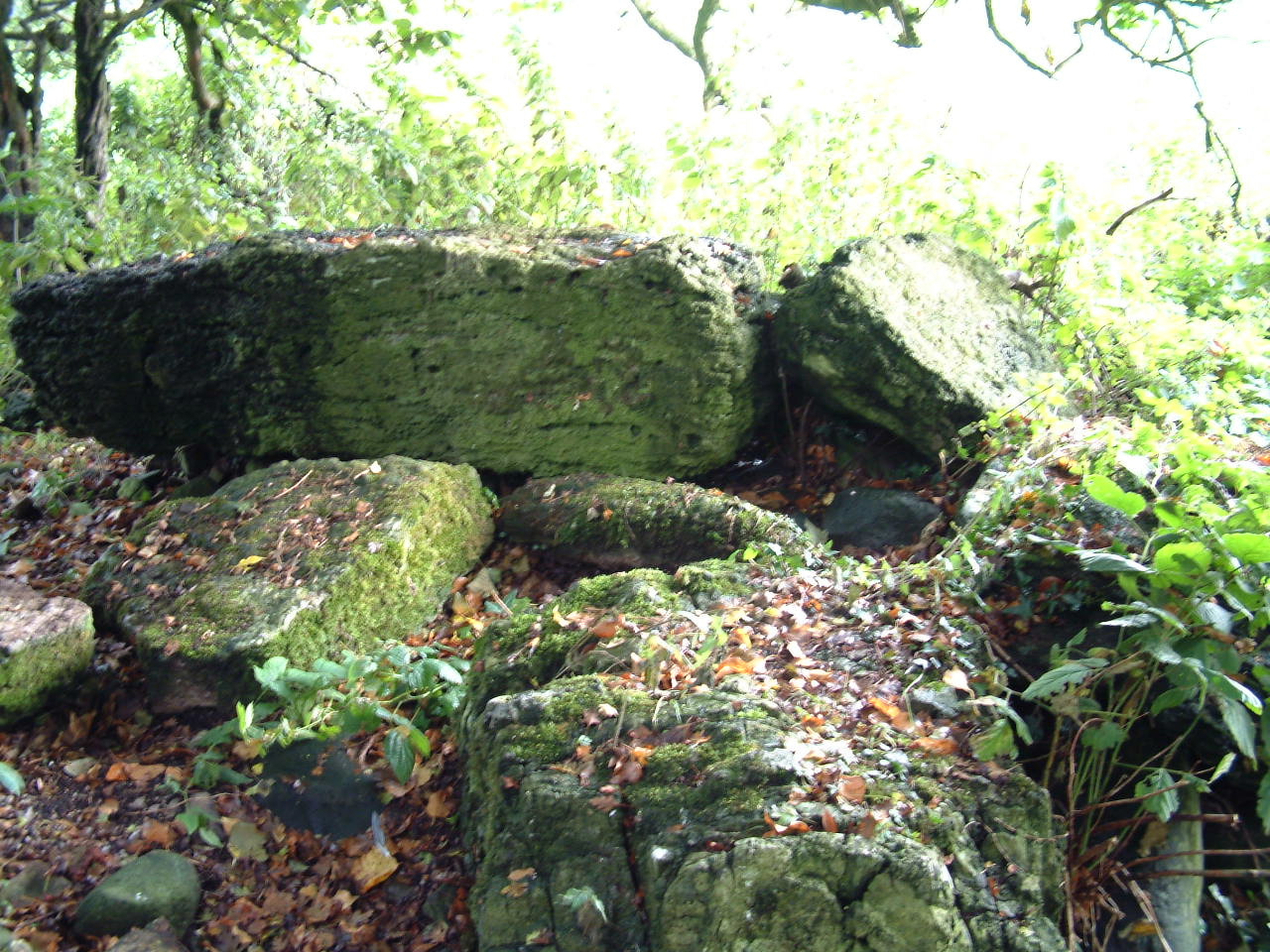
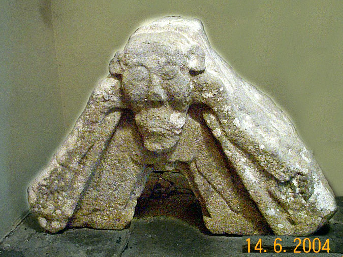
The historic sites in the townland are a double-court cairn erected c. 2,500 B.C. (Site number 31, page 7, Doon townland, in “Archaeological Inventory of County Cavan”, Patrick O’Donovan, 1995) [14]; a prehistoric ring-barrow erected c. 1,000 B.C. (Site number 107, page 22, Doon townland, in “Archaeological Inventory of County Cavan”, Patrick O’Donovan, 1995); Tomregan Church & Graveyard[15] (erected in 1756 on the site of an older church built in the 16th century) ; The ‘Tomregan Stone’ Romanesque sculpture, carved c. 1150 A.D. (Site number 1641, page 195, Doon townland, in “Archaeological Inventory of County Cavan”, Patrick O’Donovan, 1995) [16]; Ballyconnell Courthouse[17] (erected in 1833); Ballyconnell Methodist Chapel[18] (erected in 1869); Ballyconnell Market House[19] (erected in 1838); Ballyconnell Mill (erected c. 1720) [20].
References
- 1 2 Griffith’s Valuation 1857
- ↑
- ↑
- ↑
- ↑
- ↑ Tithe Applotment Books 1827
- ↑
- ↑
- ↑
- ↑ http://www.census.nationalarchives.ie/pages/1901/Cavan/Ballyconnell/Ballyconnell/
- ↑ http://www.census.nationalarchives.ie/pages/1901/Cavan/Ballyconnell/Doon/ Census of Ireland 1901
- ↑ http://www.census.nationalarchives.ie/pages/1911/Cavan/Ballyconnell/Doon/
- ↑ Census of Ireland 1911
- ↑
- ↑
- ↑
- ↑
- ↑
- ↑
- ↑