Gortmore
Gortmore (from Irish: Gort Mór meaning A Big Field) is a townland in the civil parish of Templeport, County Cavan, Ireland. It lies in the Roman Catholic parish of Templeport and barony of Tullyhaw.
Geography
Gortmore is bounded on the north by Dunglave and Gub townlands in Swanlinbar parish, on the west by Gortullaghan townland, on the south by Moherloob townland and on the east by Moherreagh townland. Its chief geographical features are a stream, a stone quarry and dug wells.
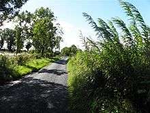
Gortmore is traversed by minor roads and rural lanes.
The townland covers 113 statute acres.[1]
History
The 1609 Baronial Map depicts the townland as Gortmore.[2]
The 1652 Commonwealth Survey spells the name as Gortmore. The 1665 Down Survey map depicts it as Gortmore.[3]
William Petty's map of 1685 depicts it as Gortmore.
In the Plantation of Ulster by grant dated 26 June 1615, King James VI and I granted, inter alia, one poll in Gortmore to Sir George Graeme and Sir Richard Graeme to form part of the Manor of Greame. An Inquisition held at Cavan Town on 31 October 1627 found that George Greames was seized of one poll in Gortmore and he died 9 October 1624. By his will dated 1 May 1615 he left his lands to his son and heir William Greames then 30 years old (born 1594) and unmarried.
The 1652 Commonwealth Survey lists the proprietor being Mr Thomas Worsopp and the tenant being William Lawther, both of whom appear as proprietor and tenant for several other Templeport townlands in the same survey.
In the Hearth Money Rolls of 1662 there was one person paying the Hearth Tax in- Cartmore- Mahon O'Logan.
The 1790 Cavan Carvaghs list spells the name as Gortmore.[4]
The Tithe Applotment Books for 1827 list eight tithepayers in the townland.[5]
In 1833 one person in Gortmore was registered as a keeper of weapons- George Magauran.[6]
In 1841 the population of the townland was 65, being 36 males and 29 females. There were eleven houses in the townland, all of which were inhabited.[7]
In 1851 the population of the townland was 42, being 19 males and 23 females, the reduction being due to the Great Famine (Ireland). There were seven houses in the townland, all were inhabited.[8]
Griffith's Valuation of 1857 lists six landholders in the townland.[9]
In 1861 the population of the townland was 36, being 19 males and 17 females. There were six houses in the townland and all were inhabited.[10]
In 1871 the population of the townland was 35, being 22 males and 13 females. There were four houses in the townland, all were inhabited.[11]
In 1881 the population of the townland was 30, being 17 males and 30 females. There were five houses in the townland, all were inhabited.[12]
In 1891 the population of the townland was 26, being 16 males and 10 females. There were five houses in the townland, all were inhabited.[13]
In the 1901 census of Ireland, there are ten families listed in the townland, [14] and in the 1911 census of Ireland, there are only six families listed in the townland.[15]
A distinguished native of the townland was Thomas McGovern (politician), M.P. for West Cavan in the House of Commons of the United Kingdom from 1900 to 1904.
Antiquities
The chief structures of historical interest in the townland are
- An earthen ringfort.[16]
References
- ↑ "IreAtlas". Retrieved 29 February 2012.
- ↑ National Archives Dublin
- ↑ Trinity College Dublin: The Down Survey of Ireland.
- ↑
- ↑
- ↑
- ↑
- ↑
- ↑
- ↑
- ↑
- ↑
- ↑
- ↑
- ↑ Census of Ireland 1911
- ↑ Site number 732 in “Archaeological Inventory of County Cavan”, Patrick O’Donovan, 1995
