Crooked Run Valley Rural Historic District
|
Crooked Run Valley Rural Historic District | |
 | |
   | |
| Location | Roughly bounded by Fauquier Cty Line, I-66, VA 712, Naked Mountain, and VA 55, near Paris, Virginia |
|---|---|
| Coordinates | 38°57′44″N 77°56′20″W / 38.96222°N 77.93889°WCoordinates: 38°57′44″N 77°56′20″W / 38.96222°N 77.93889°W |
| Area | 18,630 acres (7,540 ha) |
| Built | 1810 |
| Architect | Sutton, William; et al. |
| Architectural style | Colonial, Early Republic |
| NRHP reference # | 04000550[1] |
| VLR # | 030-5369 |
| Significant dates | |
| Added to NRHP | May 27, 2004 |
| Designated VLR | March 17, 2004[2] |
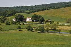
Crooked Run Valley Rural Historic District is a national historic district located near Paris, Fauquier County, Virginia. The district encompasses 386 contributing buildings, 27 contributing sites, and 21 contributing structures. It includes the separately listed Delaplane Historic District and Paris Historic District.[3]
It was listed on the National Register of Historic Places in 2004.[1]
References
- 1 2 National Park Service (2010-07-09). "National Register Information System". National Register of Historic Places. National Park Service.
- ↑ "Virginia Landmarks Register". Virginia Department of Historic Resources. Retrieved 5 June 2013.
- ↑ Debra A. McClane (November 2003). "National Register of Historic Places Inventory/Nomination: Crooked Run Valley Rural Historic District" (PDF). Virginia Department of Historic Resources. and Accompanying four photos and Accompanying map


This article is issued from
Wikipedia.
The text is licensed under Creative Commons - Attribution - Sharealike.
Additional terms may apply for the media files.