Clifton Historic District (Clifton, Virginia)
|
Clifton Historic District | |
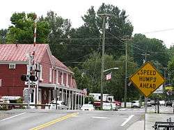 Clifton Historic District, August 2012 | |
   | |
| Location | Roughly bounded by Popes Head Creek, Water St., Dell Ave., Chestnut & Chapel Rds., Clifton, Virginia |
|---|---|
| Coordinates | 38°46′46″N 77°23′11″W / 38.77944°N 77.38639°WCoordinates: 38°46′46″N 77°23′11″W / 38.77944°N 77.38639°W |
| Area | 42 acres (17 ha) |
| Architectural style | Bungalow/craftsman, Second Empire, Neo-Gothic |
| NRHP reference # | 85001786[1] |
| VLR # | 194-0003 |
| Significant dates | |
| Added to NRHP | August 15, 1985 |
| Designated VLR | April 16, 1985[2] |
Clifton Historic District is a national historic district located at Clifton, Fairfax County, Virginia. It encompasses 62 contributing buildings, 1 contributing site, and 1 contributing object in the town of Clifton. They include 53 residences, 3 churches, 4 commercial buildings, and 2 local government buildings mostly built between 1880 and 1910. Notable buildings include the Clifton Presbyterian Church (1871), Clifton Baptist Church (1912), Clifton Hotel (1869), the Mayhugh Tavern (c. 1870), the Ford House (c. 1880), the Cross House (c. 1886), Buckley Brothers Store (c. 1900), the M. M. Payne House (1903), and "Red Gables" (1908).[3]
It was listed on the National Register of Historic Places in 1985.[1]
References
- 1 2 National Park Service (2010-07-09). "National Register Information System". National Register of Historic Places. National Park Service.
- ↑ "Virginia Landmarks Register". Virginia Department of Historic Resources. Retrieved 5 June 2013.
- ↑ Emma Jane Saxe and Elizabeth S. David (February 1985). "National Register of Historic Places Inventory/Nomination: Clifton Historic District" (PDF). Virginia Department of Historic Resources. and Accompanying photo and Accompanying map


This article is issued from
Wikipedia.
The text is licensed under Creative Commons - Attribution - Sharealike.
Additional terms may apply for the media files.