Chambers Street (IRT Broadway–Seventh Avenue Line)
Chambers Street | |||||||||||||||||
|---|---|---|---|---|---|---|---|---|---|---|---|---|---|---|---|---|---|
|
| |||||||||||||||||
_Platform.JPG) Uptown platform | |||||||||||||||||
| Station statistics | |||||||||||||||||
| Address |
Chambers Street & West Broadway New York, NY 10013 | ||||||||||||||||
| Borough | Manhattan | ||||||||||||||||
| Locale | Financial District, Tribeca | ||||||||||||||||
| Coordinates | 40°42′56″N 74°00′33″W / 40.715517°N 74.009233°WCoordinates: 40°42′56″N 74°00′33″W / 40.715517°N 74.009233°W | ||||||||||||||||
| Division | A (IRT) | ||||||||||||||||
| Line | IRT Broadway–Seventh Avenue Line | ||||||||||||||||
| Services |
1 2 3 | ||||||||||||||||
| Transit connections |
| ||||||||||||||||
| Structure | Underground | ||||||||||||||||
| Platforms |
2 island platforms cross-platform interchange | ||||||||||||||||
| Tracks | 4 | ||||||||||||||||
| Other information | |||||||||||||||||
| Opened | July 1, 1918 | ||||||||||||||||
| Station code | 327[1] | ||||||||||||||||
| Accessible |
| ||||||||||||||||
| Wireless service |
| ||||||||||||||||
| Traffic | |||||||||||||||||
| Passengers (2017) |
6,459,435[3] | ||||||||||||||||
| Rank | 69 out of 425 | ||||||||||||||||
| Station succession | |||||||||||||||||
| Next north |
14th Street (express): 2 Franklin Street (local): 1 | ||||||||||||||||
| Next south |
Park Place (express): 2 WTC Cortlandt (local): 1 | ||||||||||||||||
|
| |||||||||||||||||
| Next |
34th Street–Penn Station: 1 | ||||||||||||||||
| Next |
Fulton Street: 2 WTC Cortlandt: 1 | ||||||||||||||||
| |||||||||||||||||
| |||||||||||||||||
| |||||||||||||||||
|
| |||||||||||||||||
|
Chambers Street Subway Station (Dual System IRT) | |||||||||||||||||
| MPS | New York City Subway System MPS | ||||||||||||||||
| NRHP reference # | 05000234[4] | ||||||||||||||||
| Added to NRHP | March 30, 2005 | ||||||||||||||||


Chambers Street is an express station on the IRT Broadway–Seventh Avenue Line of the New York City Subway, located at the intersection of Chambers Street and West Broadway in Lower Manhattan. It is served by the 1 and 2 trains at all times, and the 3 train at all times except late nights.
History
A shuttle along the IRT Broadway–Seventh Avenue Line, splitting from the original line at Times Square–42nd Street and going south to 34th Street–Penn Station, had opened in 1917.[5] The shuttle line was extended south to South Ferry on July 1, 1918, with Chambers Street being one of the stops along the new extension. A shorter shuttle also ran from Chambers Street to Wall Street.[6] A new "H" system was implemented on August 1, 1918, and all trains on the Broadway–Seventh Avenue Line north of Times Square were rerouted to South Ferry or Brooklyn via the new extension, while the old IRT line via 42nd Street became the modern-day 42nd Street Shuttle.[7]
Station layout
| G | Street Level | Exit/Entrance |
| M | Mezzanine | Fare control, station agent |
| P Platform level |
Northbound local | ← |
| Island platform, doors will open on the left, right | ||
| Northbound express | ← ← | |
| Southbound express | → → | |
| Island platform, doors will open on the left, right | ||
| Southbound local | → | |
There are four tracks and two island platforms. The 1 train uses the local tracks, and the 2 and 3 trains use the express tracks. South of this station, the 2 and 3 trains curve east and branch off to Park Place, Fulton Street, Wall Street, and then Brooklyn. The 1 train continues directly south towards its terminal, South Ferry.
North of the station are diamond crossovers in both directions, allowing the 2 train to run local during late nights, switching over to the express tracks north of Chambers Street and then heading to Brooklyn; there are no crossovers south of the station due to its close proximity to Park Place. These switches were also used after the September 11, 2001 attacks, when the South Ferry branch of the line was impassable, and the 1 train was routed to Brooklyn in place of the 3 train and all trains that stopped here were local in Manhattan.
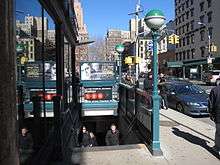
Exits
The station's only exits are through the mezzanine above the center of the station. Street stairs lead to four of the five corners of the intersection of Chambers Street, Hudson Streets, and West Broadway. The only corner without a street stair is the wedge between Hudson Street and West Broadway on the intersection's northern side, where the James Bogardus Plaza is located. The southwest corner of the intersection has two stairs.[8]
As part of a 2007–2009 renovation, three elevators were installed in the station (two from platform level to the mezzanine and one from fare control to the streets) to make it accessible for people with disabilities under the Americans with Disabilities Act of 1990.[9] The street elevator is on the northwest corner of Chambers and Hudson Streets.[8]
Nearby points of interest
References
- ↑ "Station Developers' Information". Metropolitan Transportation Authority. Retrieved June 13, 2017.
- ↑ "NYC Subway Wireless – Active Stations". Transit Wireless Wifi. Retrieved May 18, 2016.
- ↑ "Facts and Figures: Annual Subway Ridership 2012–2017". Metropolitan Transportation Authority. July 12, 2018. Retrieved July 12, 2018.
- ↑ "NPS Focus". National Register of Historic Places. National Park Service. Retrieved December 23, 2011.
- ↑ "Three New Links of the Dual Subway System Opened, Including a Shuttle Service from Times Square to Thirty-Fourth Street — Service on the Jerome Avenue Branch From 149th Street North to About 225th Street Began Yesterday Afternoon — The Event Celebrated by Bronx Citizens and Property Owners — The Seventh Avenue Connection Opened This Morning" (PDF). The New York Times. June 3, 1917. p. 1. Retrieved November 6, 2016.
- ↑ "Open New Subway to Regular Traffic — First Train on Seventh Avenue Line Carries Mayor and Other Officials — To Serve Lower West Side — Whitney Predicts an Awakening of the District — New Extensions of Elevated Railroad Service" (PDF). The New York Times. July 2, 1918. p. 11. Retrieved November 6, 2016.
- ↑ "Open New Subway Lines to Traffic; Called a Triumph — Great H System Put in Operation Marks an Era in Railroad Construction — No Hitch in the Plans — But Public Gropes Blindly to Find the Way in Maze of New Stations — Thousands Go Astray — Leaders in City's Life Hail Accomplishment of Great Task at Meeting at the Astor" (PDF). The New York Times. August 2, 1918. p. 1. Retrieved November 6, 2016.
- 1 2 3 4 5 6 7 "MTA Neighborhood Maps: Lower Manhattan" (PDF). mta.info. Metropolitan Transportation Authority. 2015. Retrieved August 21, 2015.
- ↑ "2/3 Chambers Street Elevator Installation". Lower Manhattan Construction Command Center. Retrieved 2009-06-27.
Further reading
- Stokey, Lee (1994). Subway Ceramics: A History and Iconography. ISBN 978-0-9635486-1-0.
External links
| Wikimedia Commons has media related to Chambers Street (IRT Broadway – Seventh Avenue Line). |
- nycsubway.org – IRT West Side Line: Chambers Street
- Station Reporter – 1 Train
- Station Reporter – 2 Train
- Station Reporter – 3 Train
- MTA's Arts For Transit – Chambers Street/Park Place (IRT Broadway–Seventh Avenue Line)
- Chambers Street entrance from Google Maps Street View
- Platforms from Google Maps Street View
| Topics |   | |
|---|---|---|
| Lists by county |
| |
| Lists by city | ||
| Other lists | ||
| ||