Carver Residential Historic District
|
Carver Residential Historic District | |
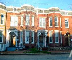 Carver Residential Historic District, December 2011 | |
  | |
| Location | 700-1500 blks. W. Leigh, 700-1400 blks. W. Catherine, Clay, & Marshall; 909-1011 W. Marshall St., Richmond, Virginia |
|---|---|
| Coordinates | 37°33′12″N 77°27′00″W / 37.55333°N 77.45000°WCoordinates: 37°33′12″N 77°27′00″W / 37.55333°N 77.45000°W |
| Area | 57 acres (23 ha) |
| Architectural style | Greek Revival, Gothic |
| NRHP reference # | 02000365, 06000975 (Boundary Increase)[1] |
| VLR # | 127-5812 |
| Significant dates | |
| Added to NRHP | April 12, 2002, November 1, 2006 (Boundary Increase) |
| Designated VLR | June 16, 1999, September 6, 2006[2] |
The Carver Residential Historic District is a national historic district located at Carver, Richmond, Virginia. The district encompasses 312 contributing buildings and 1 contributing site located west of downtown Richmond. The primarily residential area developed starting in the mid-19th century. The buildings are in a variety of popular 19th century and early 20th century architectural styles including Gothic Revival and Greek Revival. Notable buildings include the Hardin Davis House (1842), Amanda Ragland House (1843), Reuben Lacy House (1859), Rueben T. Hill House (1900), George Washington Carver Elementary School (1887), Moore Street Baptist Church (1909), Baughman Brothers/Biggs Antique Company building (1924), and the T&E Laundry Company Building (c. 1915).[3][4]
It was added to the National Register of Historic Places in 2002, with a boundary increase in 2006.[1]
References
- 1 2 National Park Service (2010-07-09). "National Register Information System". National Register of Historic Places. National Park Service.
- ↑ "Virginia Landmarks Register". Virginia Department of Historic Resources. Retrieved 19 March 2013.
- ↑ Kimberly M. Chen (March 2000). "National Register of Historic Places Inventory/Nomination: Carver Residential Historic District" (PDF). Virginia Department of Historic Resources. and Accompanying photo and Accompanying map Archived August 13, 2013, at the Wayback Machine.
- ↑ Nancy W. Kraus (May 2006). "National Register of Historic Places Inventory/Nomination: Carver Residential Historic District (Boundary Increase)" (PDF). Virginia Department of Historic Resources.

