Gamu, Isabela
| Gamu | ||
|---|---|---|
| Municipality | ||
| Municipality of Gamu | ||
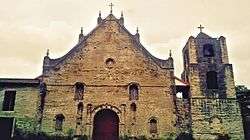 Santa Rosa de Lima Church | ||
| ||
|
Nickname(s): Gateway to Mallig Plains Mother Town of the 2nd District Oldest Town of Mallig Plains | ||
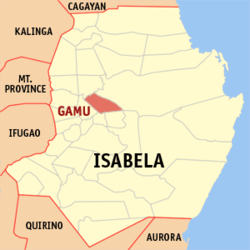 Map of Isabela with Gamu highlighted | ||
.svg.png) Gamu Location within the Philippines | ||
| Coordinates: 17°03′N 121°50′E / 17.05°N 121.83°ECoordinates: 17°03′N 121°50′E / 17.05°N 121.83°E | ||
| Country |
| |
| Region | Cagayan Valley (Region II) | |
| Province | Isabela | |
| District | 2nd District of Isabela | |
| Barangays | 16 (see Barangays) | |
| Government [1] | ||
| • Type | Sangguniang Bayan | |
| • Mayor | Nestor Malasig Uy | |
| • Vice Mayor | Nestor Lacerna | |
| • Electorate | 17,338 voters (2016) | |
| Area [2] | ||
| • Total | 129.40 km2 (49.96 sq mi) | |
| Population (2015 census)[3] | ||
| • Total | 29,904 | |
| • Density | 230/km2 (600/sq mi) | |
| Time zone | UTC+8 (PST) | |
| ZIP code | 3301 | |
| PSGC | 023113000 | |
| IDD : area code | +63 (0)78 | |
| Climate type | Tropical rainforest climate | |
| Income class | 4th municipal income class | |
| Revenue (₱) | 92,008,460.47 (2016) | |
| Poverty incidence | 16.19 (2012)[4] | |
| Native languages |
Ilocano Tagalog | |
| Website |
www | |

Gamu, officially the Municipality of Gamu, is a 4th class municipality in the province of Isabela, Philippines. According to the 2015 census, it has a population of 29,904 people.[3]
While not a commercially thriving town, it lies near Ilagan City and Cauayan, communities with banks, hospitals, and places of entertainment.
The municipality is the site of the 5th Infantry Division of Philippine Army as its infantry unit in Northern Luzon. The Infantry is located in Barangay Upi.
The town itself is famous for its baroque church, which has pointed towers at its facade.
Geography
Gamu is located in the central part of the Province of Isabela. It is approximately 10 kilometers away from the Provincial Capitol of Isabela and about 395 kilometers from the National Capital City of the Philippines, Manila.
It is bounded on the north by the city of Ilagan, or the north-west by the municipality of Quirino, on the south by the municipality of Reina Mercedes and on the south-west by the municipality of Burgos, and on the Southeast by the municipality of Naguilian.
Gamu has a total land area of 129.40 square kilometers with 16 barangays, 3 of which are classified as urban barangays, District I, II and III, and the rests are considered rural barangays.[5]
Barangays
Gamu is politically subdivided into 16 barangays. [2] District I, II, and III are considered as urban barangays while the rest are rural.[5]
| Barangay | Population (as of August 1, 2015) |
Economic Class |
Punong Barangay (Term 2013-2016) |
|---|---|---|---|
| Barcolan | 940 | Rural | Ireneo S. Calumpit |
| Buenavista | 999 | Rural | Ferdinand A. Jacob |
| Dammao | 623 | Rural | Rosalinda S. Dabo |
| District I (Poblacion) | 969 | Urban | Manuel M. Lampero |
| District II (Poblacion) | 1,984 | Urban | Alfredo P. Burkley |
| District III (Poblacion) | 2,704 | Urban | Jesus V. Villareal |
| Furao | 2,522 | Rural | Timoteo M. Galanza |
| Guibang | 2,802 | Rural | Manuel A. Calega |
| Lenzon | 1,001 | Rural | Roderick P. Lora |
| Linglingay | 1,345 | Rural | Roger G. Lumilan |
| Mabini | 4,608 | Rural | Glimerson L. Laverinto |
| Pintor | 1,366 | Rural | Norberto T. Labayog |
| RIzal | 366 | Rural | Roy B. Amigo |
| Songsong | 1,514 | Rural | Marcelino C. Tumacder |
| Union | 1,065 | Rural | Renato A. Agcaoili |
| Upi | 5,096 | Rural | George E. Gatering |
Climate
| Climate data for Gamu, Isabela | |||||||||||||
|---|---|---|---|---|---|---|---|---|---|---|---|---|---|
| Month | Jan | Feb | Mar | Apr | May | Jun | Jul | Aug | Sep | Oct | Nov | Dec | Year |
| Average high °C (°F) | 29 (84) |
30 (86) |
32 (90) |
35 (95) |
35 (95) |
35 (95) |
34 (93) |
33 (91) |
32 (90) |
31 (88) |
30 (86) |
28 (82) |
32 (90) |
| Average low °C (°F) | 19 (66) |
20 (68) |
21 (70) |
23 (73) |
23 (73) |
24 (75) |
23 (73) |
23 (73) |
23 (73) |
22 (72) |
21 (70) |
20 (68) |
22 (71) |
| Average precipitation mm (inches) | 31.2 (1.228) |
23 (0.91) |
27.7 (1.091) |
28.1 (1.106) |
113.5 (4.469) |
141.4 (5.567) |
176.4 (6.945) |
236.6 (9.315) |
224.9 (8.854) |
247.7 (9.752) |
222.9 (8.776) |
178 (7.01) |
1,651.4 (65.023) |
| Average rainy days | 10 | 6 | 5 | 5 | 13 | 12 | 15 | 15 | 15 | 17 | 16 | 15 | 144 |
| Source: World Weather Online[6] | |||||||||||||
Demographics
| Population census of Gamu | |||||||||||||||||||||||||||||||||||||||||||||||||
|---|---|---|---|---|---|---|---|---|---|---|---|---|---|---|---|---|---|---|---|---|---|---|---|---|---|---|---|---|---|---|---|---|---|---|---|---|---|---|---|---|---|---|---|---|---|---|---|---|---|
|
| ||||||||||||||||||||||||||||||||||||||||||||||||
| Source: Philippine Statistics Authority[3] [7] [8] [9] | |||||||||||||||||||||||||||||||||||||||||||||||||
In the 2015 census, the population of Gamu, Isabela, was 29,904 people,[3] with a density of 230 inhabitants per square kilometre or 600 inhabitants per square mile.
Religion
- Saint Rose of Lima Church in Barangay District 1
- Saint Michael the Archangel Cathedral in Barangay Upi
- Our Lady of Visitation of Guibang is a national shrine in Barangay Guibang[10]
- St. Clare Monastery in Barangay Guibang
- Iglesia ni Cristo Church in Barangay Upi
Festival
The town celebrated the Kuliglig festival on August 23, 2013 following an executive order issued by the Municipal Government of Gamu, Isabela.
Local government
- Mayor
- Nestor M. Uy
- Vice Mayor
- Nestor Lacerna
- Municipal Councilors
- Noel Laverinto Abaya
- Estela Burkley
- Dante Martinez
- Narciso Jr. Ordo Vercida
- Jesus Ramirez Lora
- Joey Paulo Dela Cruz
- Jose Dimagiba Lora
- Flordeliza Caro
- Gil Daggao Molano
—Commission on Elections[11]
References
- ↑ "Municipality". Quezon City, Philippines: Department of the Interior and Local Government. Retrieved 31 May 2013.
- 1 2 "Province: Isabela". PSGC Interactive. Quezon City, Philippines: Philippine Statistics Authority. Retrieved 12 November 2016.
- 1 2 3 4 Census of Population (2015). "Region II (Cagayan Valley)". Total Population by Province, City, Municipality and Barangay. PSA. Retrieved 20 June 2016.
- ↑ "PSA Releases the 2012 Municipal and City Level Poverty Estimates". Quezon City, Philippines: Philippine Statistics Authority. Archived from the original on 28 January 2017. Retrieved 28 January 2017.
- 1 2 "Facts and Figures of Gamu, Isabela". Retrieved 11 July 2014.
- ↑ "Gamu, Isabela: Average Temperatures and Rainfall". World Weather Online. Retrieved 31 October 2015.
- ↑ Census of Population and Housing (2010). "Region II (Cagayan Valley)". Total Population by Province, City, Municipality and Barangay. NSO. Retrieved 29 June 2016.
- ↑ Censuses of Population (1903–2007). "Region II (Cagayan Valley)". Table 1. Population Enumerated in Various Censuses by Province/Highly Urbanized City: 1903 to 2007. NSO.
- ↑ "Province of Isabela". Municipality Population Data. Local Water Utilities Administration Research Division. Retrieved 17 December 2016.
- ↑ "Philippine Army Band to play during procession of Our Lady of Guibang in Gamu, Isabela, on July 1". Inquirer Lifestyle. June 23, 2013. Retrieved 25 August 2013.
- ↑ Commission on Elections "Gamu, Isabela - Election Results 2013" Check
|url=value (help). Retrieved 11 July 2014.
External links
- Municipal Profile at the National Competitiveness Council of the Philippines
- Gamu at the Isabela Government Website
- Local Governance Performance Management System
- Philippine Standard Geographic Code
- Philippine Census Information
- Municipality of Gamu
Places adjacent to Gamu, Isabela | |
|---|---|
Ilagan (capital) | |
| Municipalities |
|
| Component Cities | |
| Independent Component City |
|
| Barangays | |