Alfonso Castañeda
| Alfonso Castañeda | |
|---|---|
| Municipality | |
| Municipality of Alfonso Castañeda | |
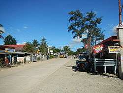 Maharlika Highway | |
| Nickname(s): Last Frontier of Nueva Viscaya | |
 Map of Nueva Vizcaya with Alfonso Castañeda highlighted | |
.svg.png) Alfonso Castañeda Location within the Philippines | |
| Coordinates: 15°48′N 121°18′E / 15.8°N 121.3°ECoordinates: 15°48′N 121°18′E / 15.8°N 121.3°E | |
| Country |
|
| Region | Cagayan Valley (Region II) |
| Province | Nueva Vizcaya |
| District | Lone district |
| Barangays | 6 (see Barangays) |
| Government [1] | |
| • Type | Sangguniang Bayan |
| • Mayor | Annie Copaos Bawayan |
| • Electorate | 5,479 voters (2016) |
| Area [2] | |
| • Total | 375.40 km2 (144.94 sq mi) |
| Population (2015 census)[3] | |
| • Total | 7,940 |
| • Density | 21/km2 (55/sq mi) |
| Time zone | UTC+8 (PST) |
| ZIP code | 3714 |
| PSGC | 025015000 |
| IDD : area code | +63 (0)78 |
| Climate type | Tropical rainforest climate |
| Income class | 1st municipal income class |
| Revenue (₱) | 73,077,754.85 (2016) |
| Native languages |
Ilocano Tagalog |
Alfonso Castañeda, officially the Municipality of Alfonso Castañeda, is a 1st class municipality in the province of Nueva Vizcaya, Philippines. According to the 2015 census, it has a population of 7,940 people.[3]
Barangays
Alfonso Castaneda is politically subdivided into 6 barangays.
- Abuyo
- Galintuja
- Cauayan
- Lipuga
- Lublub (Poblacion)
- Pelaway
Demographics
| Population census of Alfonso Castaneda | ||
|---|---|---|
| Year | Pop. | ±% p.a. |
| 1980 | 2,797 | — |
| 1990 | 3,751 | +2.98% |
| 1995 | 4,447 | +3.24% |
| 2000 | 4,808 | +1.69% |
| 2007 | 6,655 | +4.59% |
| 2010 | 7,428 | +4.08% |
| 2015 | 7,940 | +1.28% |
| Source: Philippine Statistics Authority[3] [4] [5] [6] | ||
Landmarks
- Alfonso Castañeda Municipal Hall
- Alfonso Castañeda Town Plaza
- Black Nazarene Parish Church of Alfonso Castañeda
- Casecnan River
- Mount Guiwan
 Town hall
 Parish church
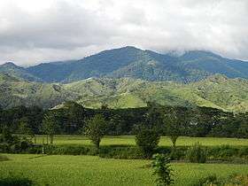
References
- ↑ "Municipality". Quezon City, Philippines: Department of the Interior and Local Government. Retrieved 31 May 2013.
- ↑ "Province: Nueva Vizcaya". PSGC Interactive. Quezon City, Philippines: Philippine Statistics Authority. Retrieved 12 November 2016.
- 1 2 3 Census of Population (2015). "Region II (Cagayan Valley)". Total Population by Province, City, Municipality and Barangay. PSA. Retrieved 20 June 2016.
- ↑ Census of Population and Housing (2010). "Region II (Cagayan Valley)". Total Population by Province, City, Municipality and Barangay. NSO. Retrieved 29 June 2016.
- ↑ Censuses of Population (1903–2007). "Region II (Cagayan Valley)". Table 1. Population Enumerated in Various Censuses by Province/Highly Urbanized City: 1903 to 2007. NSO.
- ↑ "Province of Nueva Vizcaya". Municipality Population Data. Local Water Utilities Administration Research Division. Retrieved 17 December 2016.
External links
| Wikimedia Commons has media related to Alfonso Castañeda, Nueva Vizcaya. |
- Official Website of Alfonso Castaneda
- Philippine Standard Geographic Code
- Philippine Census Information
- Local Governance Performance Management System
Places adjacent to Alfonso Castañeda | |
|---|---|
Bayombong (capital) | |
| Municipalities | |
| Barangays | |
This article is issued from
Wikipedia.
The text is licensed under Creative Commons - Attribution - Sharealike.
Additional terms may apply for the media files.