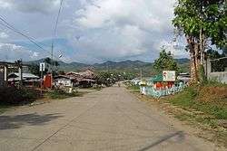
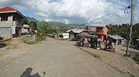
Kasibu
| Kasibu | ||
|---|---|---|
| Municipality | ||
| Municipality of Kasibu | ||
 | ||
| ||
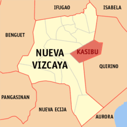 Map of Nueva Vizcaya with Kasibu highlighted | ||
.svg.png) Kasibu Location within the Philippines | ||
| Coordinates: 16°19′N 121°17′E / 16.32°N 121.28°ECoordinates: 16°19′N 121°17′E / 16.32°N 121.28°E | ||
| Country |
| |
| Region | Cagayan Valley (Region II) | |
| Province | Nueva Vizcaya | |
| District | Lone district | |
| Barangays | 30 (see Barangays) | |
| Government [1] | ||
| • Type | Sangguniang Bayan | |
| • Mayor | Alberto D. Bumolo Jr. | |
| • Electorate | 19,677 voters (2016) | |
| Area [2] | ||
| • Total | 318.80 km2 (123.09 sq mi) | |
| Population (2015 census)[3] | ||
| • Total | 37,705 | |
| • Density | 120/km2 (310/sq mi) | |
| Time zone | UTC+8 (PST) | |
| ZIP code | 3703 | |
| PSGC | 025009000 | |
| IDD : area code | +63 (0)78 | |
| Climate type | Tropical rainforest climate | |
| Income class | 3rd municipal income class | |
| Revenue (₱) | 229,381,922.54 (2016) | |
| Native languages |
Ilocano Gaddang Ilongot Tagalog | |

Kasibu, officially the Municipality of Kasibu, is a 3rd class municipality in the province of Nueva Vizcaya, Philippines. According to the 2015 census, it has a population of 37,705 people.[3]
Barangays
Kasibu is politically subdivided into 30 barangays.
- Antutot
- Alimit
- Poblacion (Alloy)
- Bilet
- Binogawan
- Bua
- Biyoy
- Capisaan
- Cordon
- Didipio
- Dine
- Kakiduguen
- Lupa
- Macalong
- Malabing
- Muta
- Pao
- Papaya
- Pudi
- Tokod
- Seguem
- Tadji
- Wangal
- Watwat
- Camamasi
- Catarawan
- Nantawacan
- Alloy
- Kongkong
- Pacquet (Ilongot Res.)
Demographics
| Population census of Kasibu | ||
|---|---|---|
| Year | Pop. | ±% p.a. |
| 1939 | 1,591 | — |
| 1948 | 693 | −8.82% |
| 1960 | 803 | +1.24% |
| 1970 | 7,952 | +25.74% |
| 1975 | 11,490 | +7.66% |
| 1980 | 15,029 | +5.51% |
| 1990 | 21,425 | +3.61% |
| 1995 | 26,252 | +3.88% |
| 2000 | 28,239 | +1.58% |
| 2007 | 31,515 | +1.53% |
| 2010 | 33,379 | +2.11% |
| 2015 | 37,705 | +2.35% |
| Source: Philippine Statistics Authority[3][4][5][6] | ||


See also
References
- ↑ "Municipality". Quezon City, Philippines: Department of the Interior and Local Government. Retrieved 31 May 2013.
- ↑ "Province: Nueva Vizcaya". PSGC Interactive. Quezon City, Philippines: Philippine Statistics Authority. Retrieved 12 November 2016.
- 1 2 3 Census of Population (2015). "Region II (Cagayan Valley)". Total Population by Province, City, Municipality and Barangay. PSA. Retrieved 20 June 2016.
- ↑ Census of Population and Housing (2010). "Region II (Cagayan Valley)". Total Population by Province, City, Municipality and Barangay. NSO. Retrieved 29 June 2016.
- ↑ Censuses of Population (1903–2007). "Region II (Cagayan Valley)". Table 1. Population Enumerated in Various Censuses by Province/Highly Urbanized City: 1903 to 2007. NSO.
- ↑ "Province of Nueva Vizcaya". Municipality Population Data. Local Water Utilities Administration Research Division. Retrieved 17 December 2016.
External links
| Wikimedia Commons has media related to Kasibu, Nueva Vizcaya. |
- Philippine Standard Geographic Code
- Philippine Census Information
- Local Governance Performance Management System
Places adjacent to Kasibu | |
|---|---|
Bayombong (capital) | |
| Municipalities | |
| Barangays | |
This article is issued from
Wikipedia.
The text is licensed under Creative Commons - Attribution - Sharealike.
Additional terms may apply for the media files.