Bristersburg Historic District
|
Bristersburg Historic District | |
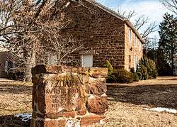 Zoar Baptist Church at the intersection of VA 806 and VA 616 | |
   | |
| Location | Area including parts of Elk Run and Bristersburg Rds., Bristersburg, Virginia |
|---|---|
| Coordinates | 38°35′00″N 77°36′50″W / 38.58333°N 77.61389°WCoordinates: 38°35′00″N 77°36′50″W / 38.58333°N 77.61389°W |
| Area | 28 acres (11 ha) |
| Built | 1838 |
| Architectural style | Queen Anne |
| NRHP reference # | 09000336[1] |
| VLR # | 030-5161 |
| Significant dates | |
| Added to NRHP | May 21, 2009 |
| Designated VLR | March 19, 2009[2] |
Bristersburg Historic District is a national historic district located at Bristersburg, Fauquier County, Virginia. It encompasses 19 contributing buildings, 1 contributing site, 1 contributing structure, and 1 contributing object in the rural crossroads of Bristersburg. They include three dwellings, a church, a school, and three stores. Notable buildings include the Tulloss Brothers Store (c. 1838), Zoar Baptist Church (1852), Eskridge House (c. 1850, c. 1890), The Bristersburg School (1910) and Payne's Store (c. 1880).[3]
It was listed on the National Register of Historic Places in 2009.[1]
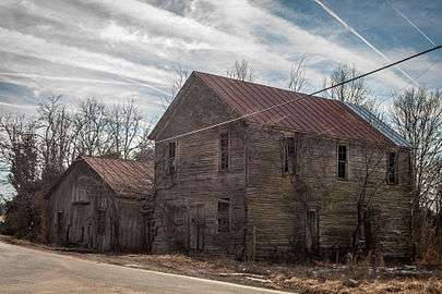 Old buildings at corner of VA 806 and VA 616
References
- 1 2 National Park Service (2010-07-09). "National Register Information System". National Register of Historic Places. National Park Service.
- ↑ "Virginia Landmarks Register". Virginia Department of Historic Resources. Retrieved 5 June 2013.
- ↑ Maral S. Kalbian and Margaret T. Peters (November 2008). "National Register of Historic Places Inventory/Nomination: Bristersburg Historic District" (PDF). Virginia Department of Historic Resources. and Accompanying five photos and Accompanying map


This article is issued from
Wikipedia.
The text is licensed under Creative Commons - Attribution - Sharealike.
Additional terms may apply for the media files.