Bob White Covered Bridge
|
Bob White Covered Bridge | |
|
Formerly listed on the U.S. National Register of Historic Places | |
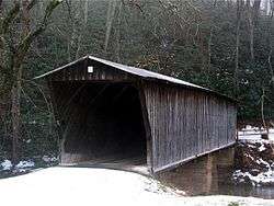 The Bob White Covered Bridge near Woolwine, Virginia. | |
| Nearest city | Woolwine, Virginia |
|---|---|
| Coordinates | 36°46′44.82″N 80°14′51.26″W / 36.7791167°N 80.2475722°WCoordinates: 36°46′44.82″N 80°14′51.26″W / 36.7791167°N 80.2475722°W |
| Area | 10 acres (4.0 ha) |
| Built | 1921 |
| Built by | Weaver, Walter |
| Architectural style | Other, Burr Arch |
| NRHP reference # | 73002049[1] |
| VLR # | 070-0027 |
| Significant dates | |
| Added to NRHP | May 22, 1973 |
| Designated VLR | April 17, 1973[2] |
| Removed from NRHP | February 7, 2017 |
The Bob White Covered Bridge, also known as the Lower Covered Bridge or Woolwine Covered Bridge, was a county-owned wooden covered bridge that spanned the Smith River in Patrick County, Virginia, United States. It was located on the old portion of Bob White Road (SR 869) off State Route 8 southeast of the community of Woolwine, about 13 miles (21 kilometers) north of Stuart. Coordinates were 36°46′44.82″N 80°14′51.26″W / 36.7791167°N 80.2475722°W (36.779117, −80.247572).
Built in 1921, the 80-foot (24-meter) bridge was a Queen-post truss construction over two spans. Its WGCB number was 46-68-01. The Bob White Covered Bridge was listed on the National Register of Historic Places on May 22, 1973. It was one of two historic covered bridges remaining in Patrick County, maintained by the Patrick County government. The bridge washed away and was destroyed in major flooding on September 29, 2015,[3] and subsequently removed from the National Register in 2017.[4]
History
The Bob White Covered Bridge was constructed by Walter G. Weaver of Woolwine, named for the former Bob White Post Office, which in turn was named after the bobwhite quails that inhabit the area. It served as an access route to the Smith River Church of the Brethren, located on the south side of the river. The bridge was bypassed to the west with a concrete bridge in 1981. Although closed to motor traffic, the Bob White Covered Bridge still attracted numerous visitors. The bridge was the site of annual horse-drawn wagon rides as part of the Patrick County Covered Bridge Festival held every June.[3]
| Bob White Covered Bridge | |
|---|---|
| Coordinates | 36°46′44.82″N 80°14′51.26″W / 36.7791167°N 80.2475722°W |
| Carries | pedestrian traffic |
| Crosses | Smith River |
| Locale | Woolwine, Virginia |
| Maintained by | Patrick County, VA |
| ID number | 46-68-01 (WGCB) |
| Characteristics | |
| Design | Queen-post truss |
| Total length | 80 ft (24 m) |
| History | |
| Construction end | 1921 |
| Closed | September 29, 2015 by flooding |
See also
References
- ↑ National Park Service (2010-07-09). "National Register Information System". National Register of Historic Places. National Park Service.
- ↑ "Virginia Landmarks Register". Virginia Department of Historic Resources. Retrieved 5 June 2013.
- 1 2 WDBJ7. "Bob White Covered Bridge in Woolwine washes away". wdbj7.com. Archived from the original on 30 September 2015. Retrieved 29 September 2015.
- ↑ National Park Service (February 17, 2017), Weekly List of Actions Taken on Properties: 2/6/2017 through 2/10/2017, archived from the original on March 8, 2017, retrieved March 8, 2017 .
- Dale J. Travis Covered Bridges. Bob White CB: Credits. Retrieved Nov. 13, 2007.
- Virginia is for Lovers: Covered Bridges in Virginia. Bob White CB: Credits. Retrieved Nov. 13, 2007.
- Virginia Department of Transportation. Bob White CB: Credits. Retrieved Nov. 13, 2007.
- Tc2U Photographs. Bob White CB: Credits. Retrieved Nov. 13, 2007.
- Patrick County Chamber of Commerce. Bob White CB: Credits. Retrieved Nov. 13, 2007.
External links
- Bob White Covered Bridge (Virginia Department of Transportation)
- Bob White Covered Bridge (Virginia Tourism Corporation)
- Bob White Covered Bridge (Dale J. Travis)

