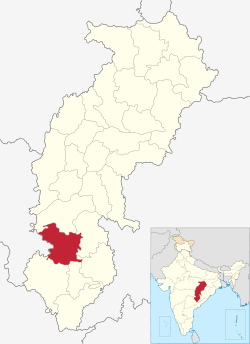
Narayanpur district
| Narayanpur district | |
|---|---|
| District of Chhattisgarh | |
 Location of Narayanpur district in Chhattisgarh | |
| Country | India |
| State | Chhattisgarh |
| Headquarters | Narayanpur, Chhattisgarh |
| Area | |
| • Total | 6,640 km2 (2,560 sq mi) |
| Population (2011) | |
| • Total | 140,206 |
| • Density | 21/km2 (55/sq mi) |
| Demographics | |
| • Literacy | 49.59 |
| Website | Official website |
Narayanpur district is one of the 27 districts of Chhattisgarh State in Central India. It is one of the two districts created on May 11, 2007. It was carved out from the erstwhile Bastar district. This district occupies an area of 6640 km² and it had a population of 110,800 in 2001. Narayanpur town is the administrative headquarters of this district.[1] This district comprises 366 villages.[2] It is currently a part of the Red Corridor.[3]
As of 2011 it is the least populous district of Chhattisgarh (out of 18).[4]
The present collector of Narayanpur is Shri Topeshwar Verma.[5]
Demographics
According to the 2011 census Narayanpur district has a population of 140,206,[4] roughly equal to the nation of Saint Lucia.[6] This gives it a ranking of 606th in India (out of a total of 640).[4] The district has a population density of 20 inhabitants per square kilometre (52/sq mi) .[4] Its population growth rate over the decade 2001-2011 was 19.49%.[4] Narayanpur has a sex ratio of 998 females for every 1000 males,[4] and a literacy rate of 49.59%.[4] Current district populations are 150771 recorded(Because Handawada area populations was not includeded 2011 census)in Narayanpur district. Handawada area populations was included in Bijapur District before.
Geography
Narayanpur District is divided into two administrative blocks:[7]
- Narayanpur, having 45 Gram Panchayats with 176 villages (172 inhabited), is spread over an area of 2760 km2.
- Orccha, having 24 Gram Panchayats with 237 villages (209 inhabited), is spread over an area of 3880 km2.
Orcha comprises the Abuzhmad region, the unsurveyed zone in central India and home to Primitive Tribal Group Madia Gond and Muriya Gond.
Narayanpur receives an average annual rainfall of 1300 mm.[7] RTC depoits - 02
References
- ↑ Srivastava, Dayawanti et al. (ed.) (2010). India 2010, A Reference Annual (PDF). New Delhi: Publications Division, Ministry of Information and Broadcasting, Government of Indiaand. p. 1122. ISBN 978-81-230-1617-7.
- ↑ "2 new districts formed in Chhattisgarh". April 20, 2010.
- ↑ "83 districts under the Security Related Expenditure Scheme". IntelliBriefs. 2009-12-11. Retrieved 2011-09-17.
- 1 2 3 4 5 6 7 "District Census 2011". Census2011.co.in. 2011. Retrieved 2011-09-30.
- ↑ http://narayanpur.gov.in
- ↑ US Directorate of Intelligence. "Country Comparison:Population". Retrieved 2011-10-01.
Saint Lucia 161,557 July 2011 est.
- 1 2 "About Narayanpur" (PDF). Archived from the original (PDF) on 2 July 2013. Retrieved 22 June 2013.
External links
Places adjacent to Narayanpur district | |
|---|---|
| Governance | 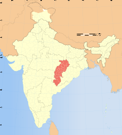 | |
|---|---|---|
| Topics | ||
| Districts | ||
| Cities | ||
| ||