Dhamtari district
| Dhamtari district | |
|---|---|
| District of Chhattisgarh | |
 Location of Dhamtari district in Chhattisgarh | |
| Country | India |
| State | Chhattisgarh |
| Headquarters | Dhamtari |
| Tehsils | Dhamtari, Kurud, Nagri |
| Government | |
| • Lok Sabha constituencies | Mahasamund, Kanker |
| • Assembly seats | Dhamtari, Kurud, Sihawa |
| Area | |
| • Total | 2,029 km2 (783 sq mi) |
| Population (2011) | |
| • Total | 799,781 |
| • Density | 390/km2 (1,000/sq mi) |
| Demographics | |
| • Literacy | 75.16 |
| • Sex ratio | 1010 |
| Major highways | NH-30 |
| Website | Official website |
Dhamtari is abbreviated from "Dhamma" + "Tarai" district and is situated in the fertile plains of the Chhattisgarh region. This district is situated at 20°42' N latitude and 81°33' E longitude. Dhamtari district was officially formed on 6 July 1998 dividing the Raipur district currently the capital of Chhattisgarh along with Mahasamund. As a result the boundaries of the Raipur district is converted into the districts e.g Raipur, Mahasamund and Dhamtari. Dhamtari, Kurud and Nagari are included in Dhamtari district as tehsils and Dhamtari, Kurud, Nagari and Magarlod are included as blocks. The total area of the district is 2029 km2 and 305 meters above mean sea level. The district is surrounded by District Raipur in the north and District Kanker as well as Bastar in the south, part of Orissa state in east and District Durg and Kanker in west. Mahanadi is the principal river of this district and Mahanadi is so far named as Kankannadi, Chitrotpala, Neelotpala, Mandvahini, Jairath, etc. Its tributaries being Sendur, Pairy, Sondur, Joan, Kharun and Shivnath. The fertility of lands of Dhamtari district can be attributed to the presence of these rivers. The chief crop of this region is paddy. Mahanadi one of the major rivers in central India originates in the hills of Sihawa and flows two the east into the Bay of Bengal. Dhamtari district falls between two Lok Sabha constituencies (Kanker and Mahasamund) and three Assembly constituencies (Dhamtari, Kurud, Sihawa). National Highway No. 30 (Previously NH 43) Raipur – Vijaynagaram (Andhra Pradesh) passes through Dhamtari. Raipur is 78 km from Dhamtari. A unique feature of Dhamtari is the total number of rice mills, more than 136. In the east, Satpura range is located. It is popularly known as Sihawa pahad. In west lies district of Kanker. In North lies Raipur, the heart and capital city of Chhattisgarh. Southwards lies the boundary of Orrisa state. Ravishankar Sagar dam that irrigates almost 57000 Hectare of land and also acts as a main supply unit of safe drinking water resource for state capital Raipur as well as supply to Bhilai Steel Plant lies at almost 11 Km from the District capital . Work of 10 MW hydro-electric power plant is progressing and is likely to be completed very soon. Asia's first ever Siphon dam was built in the year 1914 at Madamsilli. Besides Madamsilli, Sondhur dam, Dudhawa dam are the major projects.
The present collector of Dhamtari is Shri C. R. Prasanna.[1]
Geography
The Mahanadi River is the principal river of this district and till this area it is named as Kankannadi, Chitrotpala, Neelotpala, Mandvahini, Jairath, etc. Its tributaries are Sendur, Pairy, Sondur, Joan, Kharun and Shivnath. The fertility of lands of Dhamtari district can be attributed to the presence of these rivers. The chief crop of this region is paddy. Mahanadi one of the major river in central India originates in the hills of Sihawa flows in an easterly direction into the Bay of Bengal.
The National Highway No. 07 Raipur – Vijaynagaram (Andhra Pradesh) passes through Dhamtari. Raipur is 78 km from Dhamtari.
Economics
Dhamtari has over 136 rice mills.[2]
Ravishankar Sagar dam (Gangrel Dam) that irrigates almost 570 square kilometres of land and also acts as a main supply unit of safe drinking water resource for state capital Raipur as well as supply to Bhilai Steel Plant lies almost 11 km from the district capital. Two hydro-power plants of 10 MW and 1.2 MW are installed there.
Asia's first ever Syphen dam was built in 1914 at Madamsilli. Besides Madamsilli, Sondhur dam, Dudhawa dam are the major projects.
Approximately 52 per cent of the geographic area is covered by forests. The district has a tropical climate.[3]
Demographics
According to the 2011 census Dhamtari district has a population of 799,199,[4] roughly equal to the nation of Comoros[5] or the US state of South Dakota.[6] This gives it a ranking of 485th in India (out of a total of 640).[4] The district has a population density of 236 inhabitants per square kilometre (610/sq mi) .[4] Its population growth rate over the decade 2001-2011 was 13.11%.[4] Dhamtari has a sex ratio of 1012 females for every 1000 males,[4] and a literacy rate of 78.95%.[4]
This district is situated at 20°42' N latitude and 81°33' longitude. Dhamtari district was officially formed on 6 July 1998 dividing the Raipur district currently the capital of Chhattisgarh along with Mahasamund. Raipur district was broken up into the districts of Raipur, Mahasamund and Dhamtari. Dhamtari, Kurud and Nagari are included in Dhamtari district as tehsils, and blocks.
The total area of the district is 2029 km², and its altitude is 305 m above sea level. The district is surrounded by Raipur District to the north and south, and part of Orissa state to the east and west.
Dhamtari district falls between two Lok Sabha constituencies (Kanker and Mahasamund) and three assembly constituencies: Dhamtari, Kurud, and Sihawa.
References
- ↑ http://dhamtari.gov.in
- ↑ "Dhamtari Government Website". Retrieved 2006-09-22.
- ↑ "Dhamtari District NCCR". Retrieved 2006-09-22.
- 1 2 3 4 5 6 "District Census 2011". Census2011.co.in. 2011. Retrieved 2011-09-30.
- ↑ US Directorate of Intelligence. "Country Comparison:Population". Retrieved 2011-10-01.
Comoros 794,683 July 2011 est.
- ↑ "2010 Resident Population Data". U. S. Census Bureau. Archived from the original on 2013-10-19. Retrieved 2011-09-30.
South Dakota 814,180
External links
Places adjacent to Dhamtari district | ||||||||||
|---|---|---|---|---|---|---|---|---|---|---|
| ||||||||||
| Governance | 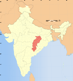 | |
|---|---|---|
| Topics | ||
| Districts | ||
| Cities | ||
| ||
Coordinates: 20°42′26″N 81°32′59″E / 20.70722°N 81.54972°E