Chuzhali
| Chuzhali | |
|---|---|
| Village | |
| Coordinates: 12°05′30″N 75°26′29″E / 12.0916400°N 75.441400°ECoordinates: 12°05′30″N 75°26′29″E / 12.0916400°N 75.441400°E | |
| Country |
|
| State | Kerala |
| District | Kannur |
| Population (2001) | |
| • Total | 13,898 |
| Languages | |
| • Official | Malayalam, English |
| Time zone | UTC+5:30 (IST) |
| PIN | 670142 |
| ISO 3166 code | IN-KL |
| Nearest city | Taliparamba |
| Vidhan Sabha constituency | Irikkoor |
Chuzhali is a village in Kannur district in the Indian state of Kerala.
History
Chuzhali village got its name from goddess Chuzhali, as this village is the abode of Goddess Chuzhali (Durga). The primary place of worship in this village is the Chuzhali Bhagavathy temple. Actually this village was under the dynasty of "Chuzhali Nambiars" . In ancient times it was under "Chuzhali Swaroopam" and the boundary was till "Koorgu" in Karnataka. Karakkattedam was heading the Chuzhali Swaroopam having control over all other edams and vast areas of land. Temples spread over Payyavur, Eruvassi, Ellaringi, Chengalai, Irukkur and Kalyadu villages come under Chuzhali Swaroopam. As the kaleidoscope of history spread over a century tilted, set patterns of social set up gave way to new order. The existence of British rule brought great changes at the national level. Princely States gave way to States and the Union of India. The Kerala Land Reforms Act brought about drastic changes in the janmi (landlord)-kudiyan (tenant) relations. With the dawn of the Temple Entry Proclamation, an upsurge of social interaction began. The so-called underprivileged gained self-respect and self-confidence, paving way for a quantum leap forward. Nationalisation of forests also played a vital role in shaking the foundations of the previously unchallenged upper echelons of society. In many cases, landlords were turned into landless and vice versa.
Once Karakkattedam had sway over vast acres of land. Records say that it had around 350,000 acres (1,400 km2) of land directly and another 150,000 acres (610 km2) indirectly, including devaswoms. Until 1960, Karakkattedam was considered to be one of the biggest landlords. During British period, Karakkattedam was entrusted with the powers to collect taxes. Both the Kerala Land Reforms Act and Nationalisation of forests affrected its edifice.
Muslims are the second biggest population in Chuzhali and Christians the third. Like any other village in Kerala, people of all these religions live peacefully and in perfect harmony and brotherhood in Chuzhali village too.
Ancient families
Main Nambiar families in this place are Padappayil, Palakkal, Edayath, Manheri and Arayakkil. In 'Malabar mannual' William Logan mentioned Chuzhali as ideal place for gorilla war, since the main land of Chuzhali is surrounded by high altitude areas namely Kulathur, Thalakkulam, Edakkulm, and Kuunam. Chuzhali Nambiar was one of the commanders of Pazhashiraja's gorilla army. It is said that Pazhashiraja had visited Chuzhali during his struggle against British army. Chuzhali nambiar was caught by British army and was hung at Thalassery. Prominent Namboodiri families include Puthussery, Palika and Mangalam. There were sixteen Namboodiri families in Chuzhali Desam. All but three are extinct due to the practices of 'sambandham', where only the eldest member in the family marry a Namboodiri girl, and the younger brothers marry non-namboodiris.
Politics
Now Chuzhali is main vote bank of Communist Party of India (Marxist).
Temples
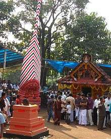
Chuzhali Bhagavathi is a famous temple situated in the middle of the Chuzhali village. The annual festival of this temple takes place during March–April. This festival is treated by people of Chuzhali as their village festival. The main attractive place of village is Kulathur 3 km from Chuzhali main town Chalilvayal.[1]
Demographics
As of 2001 India census, Chuzhali had a population of 13898 with 6836 males and 7062 females.[1] Another famous temple in Chuzhali village is "thiruvambadi" lord Sreekrishna.
Transportation
The national highway passes through Taliparamba town. Goa and Mumbai can be accessed on the northern side and Cochin and Thiruvananthapuram can be accessed on the southern side. Taliparamba has a good bus station and buses are easily available to all parts of Kannur district. The road to the east of Iritty connects to Mysore and Bangalore. But buses to these cities are available only from Kannur, 22 km to the south. The nearest railway stations are Kannapuram and Kannur on Mangalore-Palakkad line. Trains are available to almost all parts of India subject to advance booking over the internet. There are airports at Kannur, Mangalore and Calicut. All of them are small international airports with direct flights available only to Middle Eastern countries.
References
- 1 2 "Census of India : Villages with population 5000 & above". Registrar General & Census Commissioner, India. Archived from the original on 2008-12-08. Retrieved 2008-12-10.