Hjørundfjord
| Hjørundfjord herad | |
|---|---|
| Former Municipality | |
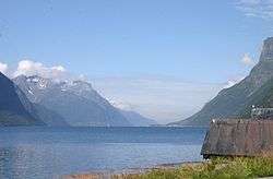 Hjørundfjorden from the south (in from the section called Storfjorden by Viddal) | |
 Hjørundfjord Location in Møre og Romsdal | |
| Coordinates: 62°12′33″N 06°28′11″E / 62.20917°N 6.46972°ECoordinates: 62°12′33″N 06°28′11″E / 62.20917°N 6.46972°E | |
| Country | Norway |
| Region | Western Norway |
| County | Møre og Romsdal |
| District | Sunnmøre |
| Adm. Center | Sæbø |
| Area[1] | |
| • Total | 277 km2 (107 sq mi) |
| ISO 3166 code | NO-1522 |
| Created as | Formannskapsdistrikt in 1838 |
| Merged into | Ørsta Municipality in 1964 |
Hjørundfjord is a former municipality in Møre og Romsdal county, Norway. It is now a part of Ørsta Municipality. The administrative centre was the village of Sæbø, located on the shores of the Hjørundfjorden. The municipality encircled both sides of the Hjørundfjorden as well as the Bondalen valley. The villages of Bjørke, Leira, and Store Standal were all a part Hjørundfjord Municipality.[1]
History
The municipality was established on 1 January 1838 (see formannskapsdistrikt). The original municipality was the same as the parish (prestegjeld) of Hjørundfjord. On 1 January 1964, Hjørundfjord and the neighboring municipalities of Vartdal and Ørsta were merged into one large Ørsta Municipality. Prior to the merger, Hjørundfjord had a population of 1,728.[2]
Notable residents
- Knut Skram (born 1937), baritone
- Rasmus Skylstad (1893–1972), diplomat
References
- 1 2 Store norske leksikon. "Hjørundfjord. – tidl. kommune i Møre og Romsdal" (in Norwegian). Archived from the original on 2012-10-11. Retrieved 2010-09-22.
- ↑ Jukvam, Dag (1999). "Historisk oversikt over endringer i kommune- og fylkesinndelingen" (PDF) (in Norwegian). Statistisk sentralbyrå.
External links
| Look up Hjørundfjord in Wiktionary, the free dictionary. |
| Wikivoyage has a travel guide for Hjørundfjord. |
- Official website about Hjørundfjorden (in Norwegian)