Sæbø, Møre og Romsdal
| Sæbø | |
|---|---|
| Village | |
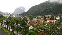 View of Sæbø | |
 Sæbø Location in Møre og Romsdal  Sæbø Sæbø (Norway) | |
| Coordinates: 62°12′24″N 06°28′30″E / 62.20667°N 6.47500°ECoordinates: 62°12′24″N 06°28′30″E / 62.20667°N 6.47500°E | |
| Country | Norway |
| Region | Western Norway |
| County | Møre og Romsdal |
| District | Sunnmøre |
| Municipality | Ørsta Municipality |
| Elevation[1] | 7 m (23 ft) |
| Time zone | UTC+01:00 (CET) |
| • Summer (DST) | UTC+02:00 (CEST) |
| Post Code | 6165 Sæbø |
Sæbø is a village in Ørsta Municipality in Møre og Romsdal county, Norway. The village is located along the Hjørundfjorden in the Bondalen valley. It is about 5 kilometres (3.1 mi) north of the mountain Skårasalen. The village of Store-Standal lies about 6 kilometres (3.7 mi) to the north and the villages of Leira and Bjørke lie about 11 kilometres (6.8 mi) to the south.
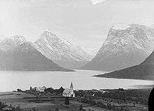
View of Sæbø from the 1880s
Sæbø was the administrative centre of the former municipality of Hjørundfjord which was incorporated into Ørsta municipality in 1964.
References
This article is issued from
Wikipedia.
The text is licensed under Creative Commons - Attribution - Sharealike.
Additional terms may apply for the media files.