Tuscaloosa County, Alabama
Tuscaloosa County is a county in the northwest-central portion of the U.S. state of Alabama.[1] As of the 2010 census, its population was 194,656[2] (estimated at 209,355 in 2019 by the United States Census Bureau). Its county seat and largest city is Tuscaloosa, the former state capital from 1826 to 1845.[1][3] The county is named in honor of Tuskaloosa, a paramount chief of the Mississippian culture, who are considered ancestors of the historic Choctaw people of the region.[1][4]
Tuscaloosa County | |
|---|---|
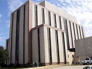 Tuscaloosa County Courthouse in Tuscaloosa | |
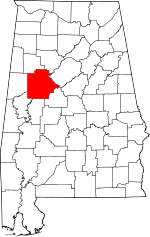 Location within the U.S. state of Alabama | |
 Alabama's location within the U.S. | |
| Coordinates: 33°12′24″N 87°32′05″W | |
| Country | |
| State | |
| Founded | February 6, 1818[1] |
| Named for | Tuskaloosa |
| Seat | Tuscaloosa |
| Largest city | Tuscaloosa |
| Area | |
| • Total | 1,351 sq mi (3,500 km2) |
| • Land | 1,322 sq mi (3,420 km2) |
| • Water | 30 sq mi (80 km2) 2.2%% |
| Population (2010) | |
| • Total | 194,656 |
| • Estimate (2019) | 209,355 |
| • Density | 140/sq mi (56/km2) |
| Time zone | UTC−6 (Central) |
| • Summer (DST) | UTC−5 (CDT) |
| Congressional districts | 4th, 7th |
| Website | www |
| |
Tuscaloosa County is included in the Tuscaloosa, AL Metropolitan Statistical Area. The county is the home of the University of Alabama, Shelton State Community College, and Stillman College.
History
Tuscaloosa County was established on February 6, 1818. During the antebellum years, the principal crop was cotton, cultivated and processed by African-American slaves. By 1860, shortly before the state seceded from the Union, the county had a total of 12,971 whites, 84 "free" African Americans, and 10,145 African-American slaves; the latter comprised 43.7 percent of the total population.[5] The war brought significant changes, including migration out of the county by some African Americans.[5] Some freedmen moved to nearby counties and larger cities for more opportunities and to join with other freedmen in communities less subject to white supervision and intimidation.[5]
Following Reconstruction, there was violence as whites struggled to regain control of the state legislature. It reached a height in the late 19th and early 20th centuries. Tuscaloosa County had a total of 10 documented lynchings of African Americans, according to a 2015 study by the Equal Justice Initiative.[6]
Following passage by Alabama of the 1901 constitution that disenfranchised most African Americans and tens of thousands of poor whites, the state legislature passed laws to impose Jim Crow and racial segregation. Due to this oppression and problems of continued violence by lynchings, many African Americans left Alabama in two waves of the Great Migration in the first half of the 20th century. They went to Northern and Midwestern industrial cities. Their mass departure from Tuscaloosa County is reflected in the lower rates of county population growth from 1910 to 1930, and from 1950 to 1970. (see Census Table below.)
Blacks by 1960 represented 28.7% of the county population and they were still disenfranchised throughout the state. African Americans were active in demonstrations and other civil rights activities in the city of Tuscaloosa in the 1960s, seeking desegregation of public facilities, including the county courthouse. After passage of the federal Voting Rights Act of 1965, African Americans in the state regained their ability to exercise their constitutional right to vote and participate in the political system. Politics in the state have shifted since they recovered the vote. They have generally supported the Democratic Party, which on the national level had supported the civil rights movement.
While the county population has increased considerably since 1960, African Americans still comprise slightly less than one third of the total. In 2015, one of the four elected Tuscaloosa County Commissioners is African American.
Since the late 20th century, by contrast, white conservatives in Alabama and other southern states have essentially shifted to supporting Republican Party candidates, particularly for statewide and national offices.
In the 21st century, the principal agricultural products have included hay, corn, cotton, soybeans, wheat and snapdragons.[1] Major companies in the county have included JVC, Mercedes-Benz U.S. International, Uniroyal-Goodrich, and Phifer Inc.[1]
Major tornado incidents
1932
On March 21, 1932, a F4 tornado hit the Tuscaloosa–Northport area in Tuscaloosa County. This storm was part of a massive tornado outbreak over March 21–22, 1932, spawning at least 36 tornadoes which killed more than 330 people and injuring 2,141. Alabama was hardest hit, with 268 fatalities.
1998
On April 8, 1998, an F3 tornado struck northeast of Tuscaloosa. This windstorm injured two people and destroyed five homes and 11 mobile homes. It rotated seventeen miles (27 km) from Holman to north of Northport. Thirty-seven homes were also damaged. Moments later, a separate F5 tornado struck northeastern Tuscaloosa near the Black Warrior River before entering western Jefferson County, where it caused 32 deaths.
2000
On December 16, 2000, an F4 rated tornado hit communities south and east of Tuscaloosa, centering in the Bear Creek and Hillcrest Meadows areas. The tornado caused the deaths of 11 people while injuring over 125 others. It was the strongest tornado to hit Alabama in the month of December since 1950 and the strongest of a moderate tornado outbreak that took place across the Southeastern corner of the United States from Mississippi to North Carolina. Damage was estimated at over $12 million. More than 40 houses and 70 mobile homes were completely destroyed, with hundreds more seriously damaged.
2011
On April 27, 2011, Tuscaloosa was hit by a half-mile (800 m) wide tornado, which was part of the 2011 Super Outbreak. It resulted in at least 44 deaths in the city, over 1000 injuries, and massive devastation.[7][8] Officials at DCH Hospital (alone) in Tuscaloosa reported treating more than 1000 injured people in the first several days of the tornado aftermath.[9] Mayor Maddox was quoted saying that "We have neighborhoods that have been basically removed from the map."[10]
On April 29, President Barack Obama, upon touring the tornado damage in Tuscaloosa, said "I have never seen devastation like this".[11]
Geography
According to the U.S. Census Bureau, the county has a total area of 1,351 square miles (3,500 km2), of which 1,322 square miles (3,420 km2) is land and 30 square miles (78 km2) (2.2%) is water.[12] It is the second-largest county in Alabama by land area and third-largest by total area. It is located in the west central part of the state, in the region commonly known as West Alabama. The county straddles the boundary between the Appalachian Highlands and the Gulf Coastal Plain and consequently boasts a diverse geography.
Adjacent counties
- Walker County (northeast)
- Jefferson County (east)
- Bibb County (southeast)
- Hale County (south)
- Greene County (southwest)
- Pickens County (west)
- Fayette County (northwest)
National protected area
- Talladega National Forest (part)
Demographics
| Historical population | |||
|---|---|---|---|
| Census | Pop. | %± | |
| 1820 | 8,229 | — | |
| 1830 | 13,646 | 65.8% | |
| 1840 | 16,583 | 21.5% | |
| 1850 | 18,056 | 8.9% | |
| 1860 | 23,200 | 28.5% | |
| 1870 | 20,081 | −13.4% | |
| 1880 | 24,957 | 24.3% | |
| 1890 | 30,352 | 21.6% | |
| 1900 | 36,147 | 19.1% | |
| 1910 | 47,559 | 31.6% | |
| 1920 | 53,680 | 12.9% | |
| 1930 | 64,153 | 19.5% | |
| 1940 | 76,036 | 18.5% | |
| 1950 | 94,092 | 23.7% | |
| 1960 | 109,047 | 15.9% | |
| 1970 | 116,029 | 6.4% | |
| 1980 | 137,541 | 18.5% | |
| 1990 | 150,522 | 9.4% | |
| 2000 | 164,875 | 9.5% | |
| 2010 | 194,656 | 18.1% | |
| Est. 2019 | 209,355 | [13] | 7.6% |
| U.S. Decennial Census[14] 1790–1960[15] 1900–1990[16] 1990–2000[17] 2010–2018[2] | |||
As of the census of 2000, there were 164,875 people, 64,517 households, and 41,677 families residing in the county. The population density was 124 per square mile (48 persons/km2). The population core of the county lies in Tuscaloosa-Northport conurbation (including Coaling, Coker, and Holt CDP). The combined 2000 Census population of this area (not including their undesignated suburban census areas) is 103,367, accounting for 62.7% of the county in population, while only accounting for 6.9% in area. Consequently, the population density of the central population core is 1,137 persons per square mile (439 persons/km2), while the density of the county outside the central population core is only 44 persons per square mile (17 persons/km2).
There were 71,429 housing units at an average density of 54 per square mile (21/km2). The racial makeup of the county was 68.12% White, 29.31% Black or African American, 0.23% Native American, 0.92% Asian, 0.03% Pacific Islander, 0.56% from other races, and 0.82% from two or more races. Nearly 1.29% of the population were Hispanic or Latino of any race.
According to the 2000 census the largest ancestry groups in Tuscaloosa County were: 31.2% English, 29.31% African, 8.9% Irish, 7% German, 2.9% Scots-Irish and 2% Scottish.
There were 64,517 households, out of which 30.30% had children under the age of 18 living with them; 47.20% were married couples living together, 14.00% had a female householder with no husband present, and 35.40% were non-families. 28.40% of all households were made up of individuals, and 8.30% had someone living alone who was 65 years of age or older. The average household size was 2.42, and the average family size was 3.00.
In the county, the population was spread out with 23.40% under the age of 18, 16.50% from 18 to 24, 28.10% from 25 to 44, 20.80% from 45 to 64, and 11.30% who were 65 years of age or older. The median age was 32 years. For every 100 females, there were 92.80 males. For every 100 females age 18 and over, there were 89.50 males.
The median income for a household in the county was $34,436, and the median income for a family was $45,485. Males had a median income of $34,807 versus $24,128 for females. The per capita income for the county was $18,998. About 11.30% of families and 17.00% of the population were below the poverty line, including 19.50% of those under age 18 and 13.20% of those age 65 or over.
2010 census
As of the census of 2010, there were 194,656 people, 76,141 households, and 46,304 families residing in the county. The population density was 147 per square mile (57 persons/km2). There were 84,872 housing units at an average density of 64 per square mile (25/km2). The racial makeup of the county was 66.3% White, 29.6% Black or African American, 0.3% Native American, 1.2% Asian, 0.1% Pacific Islander, 1.5% from other races, and 1.1% from two or more races. Nearly 3.1% of the population were Hispanic or Latino of any race.
There were 76,141 households, out of which 26.4% had children under the age of 18 living with them; 41.6% were married couples living together, 14.9% had a female householder with no husband present, and 39.2% were non-families. 29.2% of all households were made up of individuals, and 7.7% had someone living alone who was 65 years of age or older. The average household size was 2.42, and the average family size was 3.02.
In the county, the population was spread out with 21.5% under the age of 18, 19.7% from 18 to 24, 25.2% from 25 to 44, 22.9% from 45 to 64, and 10.8% who were 65 years of age or older. The median age was 31.2 years. For every 100 females, there were 94.2 males. For every 100 females age 18 and over, there were 95.3 males.
The median income for a household in the county was $42,311, and the median income for a family was $58,756. Males had a median income of $42,424 versus $32,163 for females. The per capita income for the county was $22,546. About 11.3% of families and 19.7% of the population were below the poverty line, including 22.4% of those under age 18 and 10.1% of those age 65 or over.
Government and politics
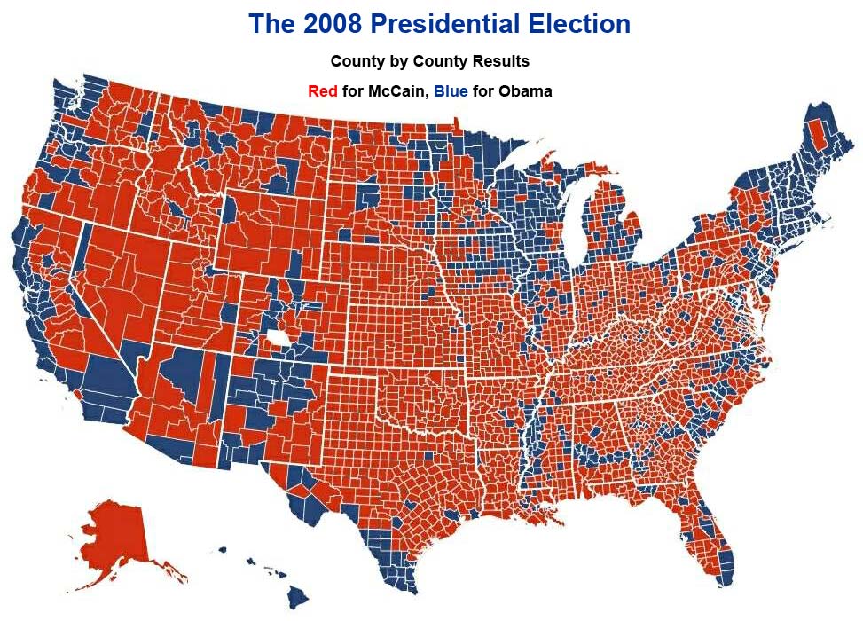
As a historically conservative, white-majority region since the mid-20th century, Tuscaloosa County voted for John McCain over Barack Obama in the 2008 Election by a margin of 58-42%. But Obama attracted high turnout and many votes from young people and others, in addition to the African-American minority. The latter make up 28.9% of the population of the county and have supported Democrats in national elections since the civil rights era and restoration of their constitutional right to vote.[18]
| Year | GOP | DEM | Others |
|---|---|---|---|
| 2016 | 57.7% 47,723 | 38.4% 31,762 | 3.9% 3,215 |
| 2012 | 58.1% 45,748 | 40.7% 32,048 | 1.2% 976 |
| 2008 | 57.5% 45,405 | 41.6% 32,796 | 0.9% 711 |
| 2004 | 61.4% 42,877 | 37.9% 26,447 | 0.7% 506 |
| 2000 | 56.6% 34,003 | 41.0% 24,614 | 2.5% 1,497 |
| 1996 | 51.4% 27,939 | 42.4% 23,067 | 6.2% 3,376 |
| 1992 | 47.3% 27,454 | 40.5% 23,495 | 12.3% 7,124 |
| 1988 | 59.9% 27,396 | 39.7% 18,166 | 0.4% 196 |
| 1984 | 62.8% 28,075 | 35.9% 16,066 | 1.3% 598 |
| 1980 | 48.5% 19,750 | 46.9% 19,103 | 4.6% 1,867 |
| 1976 | 43.3% 16,021 | 54.8% 20,275 | 1.9% 710 |
| 1972 | 70.2% 21,172 | 27.4% 8,272 | 2.4% 735 |
| 1968 | 13.5% 3,822 | 19.6% 5,556 | 67.0% 18,993 |
| 1964 | 68.7% 13,227 | 31.3% 6,036 | |
| 1960 | 40.0% 5,598 | 59.0% 8,254 | 1.0% 140 |
| 1956 | 36.2% 4,994 | 59.3% 8,186 | 4.5% 618 |
| 1952 | 33.0% 3,872 | 65.5% 7,677 | 1.5% 171 |
| 1948 | 12.1% 658 | 87.9% 4,797 | |
| 1944 | 10.5% 584 | 88.6% 4,939 | 0.9% 50 |
| 1940 | 6.3% 426 | 93.4% 6,284 | 0.3% 22 |
| 1936 | 5.2% 332 | 94.3% 6,029 | 0.5% 32 |
| 1932 | 5.3% 302 | 94.1% 5,322 | 0.6% 32 |
| 1928 | 30.4% 1,210 | 69.6% 2,769 | 0.1% 2 |
| 1924 | 9.0% 247 | 85.8% 2,363 | 5.2% 144 |
| 1920 | 12.4% 491 | 86.9% 3,438 | 0.7% 27 |
| 1916 | 8.1% 218 | 90.0% 2,437 | 2.0% 53 |
| 1912 | 4.4% 87 | 85.2% 1,695 | 10.4% 207 |
| 1908 | 8.0% 162 | 85.1% 1,729 | 7.0% 142 |
| 1904 | 8.3% 132 | 88.2% 1,405 | 3.5% 56 |
Tuscaloosa County is one of seven in the state with limited home rule. It must still gain state legislative approval on many issues, including for financial measures. The four-member County Commission is elected from single-member districts.[20]
Judges are also elected. The current District Court Judges are:
- Judge Joanne Jannik
- Judge Jim Gentry
The current Circuit Court Judges in no particular order are:
- Judge Allen W. May, Jr.
- Judge M. Bradley Almond, Presiding Judge
- Judge John H. England, Jr.
- Judge James H. Roberts, Jr.
- Judge Phillip N. Lisenby
- Judge Elizabeth C. Hamner
The current Clerk of the Circuit Court is Magaria H. Bobo.
The current County Sheriff is Ron Abernathy. The chief law enforcement officer of Tuscaloosa County, which comprises the Sixth Judicial Circuit, is Hays Webb, District Attorney, also an elected position.
On the federal level, Tuscaloosa County is divided between the fourth and seventh congressional districts of Alabama, represented by Robert Aderholt (R) and Terri Sewell (D), respectively. The 7th district includes much of the Black Belt and is a majority-minority district, with a predominantly African-American majority.
Tuscaloosa County is within the northern federal court district of Alabama.
Education
The Tuscaloosa County School System serves students in the county who live outside the city limits of Tuscaloosa. The system has been in operation since 1871. The system is managed by a board of education, composed of 7 members elected by single-member districts by the voters of the county outside the limits of the city of Tuscaloosa. The board appoints a superintendent to manage the day-to-day operations of the system. In school year 2012–13, almost 18,000 students were enrolled by the system. There are 19 elementary schools, 8 middle schools, 6 high schools. Children are also served at the Tuscaloosa Regional Detention Center and Sprayberry Regional Educational Center; the latter provides services to gifted and special needs children. The six county high schools are Brookwood High School (Brookwood), Hillcrest High School (Taylorville), Holt (Holt), Northside (Samantha), Sipsey Valley (Coker), and Tuscaloosa County High School (Northport).
The Tuscaloosa City School System serves students who live in the city of Tuscaloosa. There are approximately 10,000 students enrolled in Tuscaloosa City Schools. Twenty-four schools comprise the district, including 13 elementary schools, 6 middle schools, 3 high schools and 3 campuses dedicated to specialty education: one for students with special needs and those receiving alternative education, a school for students studying performing arts, and a career technical facility for grades 9 – 12. The three high schools are Paul W. Bryant High School, Central High School, and Northridge High School.
Post secondary education is provided by the University of Alabama and Stillman College, a historically black college founded in 1876. Both are located in the city of Tuscaloosa and both are four-year schools. Shelton State Community College is one of the largest two-year community colleges in the state, and has two campuses in Tuscaloosa.
Constructions
The TV Alabama Tower and the WTTO Tower near Windham Springs are guyed TV masts. These are the tallest constructions in Tuscaloosa County.
Transportation
Major highways
Toll Roads/Bridges
| Road Name | S/W Terminus | N/E Terminus | Length | Cash tolls (automobile) | Notes |
|---|---|---|---|---|---|
| Black Warrior Parkway | 4.9 mi. | $1.50 |
Communities
Cities
- Northport
- Tuscaloosa (county seat)
Towns
- Brookwood
- Coaling
- Coker
- Lake View
- Moundville (partly in Hale County)
- Vance (partly in Bibb County)
- Woodstock (partly in Bibb County)
Census-designated places
Other unincorporated communities
Ghost towns
See also
- National Register of Historic Places listings in Tuscaloosa County, Alabama
- Properties on the Alabama Register of Landmarks and Heritage in Tuscaloosa County, Alabama
References
- "ACES Winston County Office" (links/history), Alabama Cooperative Extension System (ACES), 2007, webpage: ACES-Tuscaloosa.
- "State & County QuickFacts". United States Census Bureau.
- "Find a County". National Association of Counties. Retrieved 2011-06-07.
- United States Census Bureau. "2010 Census Data". United States Census Bureau. Retrieved May 12, 2012.
- Tom Blake, "MIGRATION OF FORMER SLAVES", Tuscaloosa County, AL, February 2002, at Rootsweb
- "Supplement: Lynchings by County/ Alabama: Tuscaloosa", 3rd edition, from Lynching in America: Confronting the Legacy of Racial Terror, 2015, Equal Justice Institute, Montgomery, Alabama
- "Twister Outbreak is Second Deadliest in History", NBC News, AP News & Reuters (jointly produced article), April 30, 2011, http://www.nbcnews.com/id/42834400
- "Tuscaloosa tornadoes: Death toll at 36, Mayor Walt Maddox says | al.com". Blog.al.com. Retrieved 2013-07-10.
- Reuters, https://www.reuters.com/article/2011/04/29/us-usa-weather-children-idUSTRE73S7MU20110429
- "Twister debris searched; nearly 300 dead - Weather | NBC News". NBC News. 2011-04-29. Retrieved 2013-07-10.
- "President Obama, First Lady Tour Alabama Tornado Damage - ABC News". Abcnews.go.com. April 29, 2011. Retrieved July 10, 2013.
- "2010 Census Gazetteer Files". United States Census Bureau. August 22, 2012. Retrieved August 22, 2015.
- "Population and Housing Unit Estimates". Retrieved May 16, 2019.
- "U.S. Decennial Census". United States Census Bureau. Retrieved August 22, 2015.
- "Historical Census Browser". University of Virginia Library. Retrieved August 22, 2015.
- Forstall, Richard L., ed. (March 24, 1995). "Population of Counties by Decennial Census: 1900 to 1990". United States Census Bureau. Retrieved August 22, 2015.
- "Census 2000 PHC-T-4. Ranking Tables for Counties: 1990 and 2000" (PDF). United States Census Bureau. April 2, 2001. Retrieved August 22, 2015.
- "Election Map: Counties", Phil Hardwick blog, November 2008
- "Dave Leip's Atlas of U.S. Presidential Elections". Retrieved November 21, 2016.
- "County Commission", Tuscaloosa County Commission website
External links
- Official City of Tuscaloosa Homepage
- Tuscaloosa County District Attorney's Office
- Chamber of Commerce of West Alabama
- Tuscaloosa Convention and Visitor's Bureau
- Tuscaloosa County Industrial Development Authority
- Tuscaloosa Public Library
- Official Tuscaloosa County Sheriff's Office Homepage
- Tuscaloosa County Probate Records
- Online Tuscaloosa
- Arts Council of Tuscaloosa
- Tuscaloosa Symphony Orchestra
- Tuscaloosa County Jail Information
- Destination Tuscaloosa Magazine
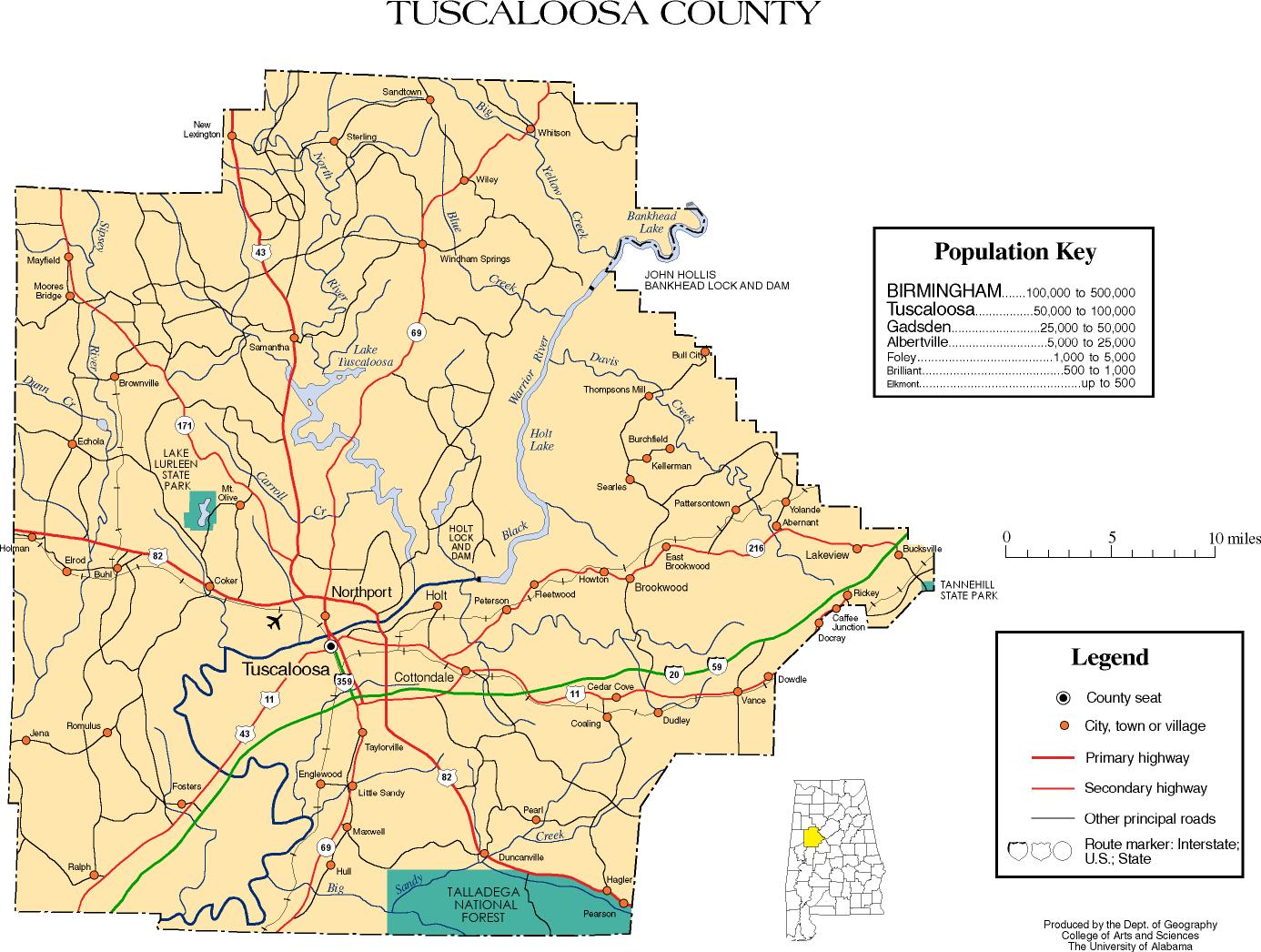
- Tuscaloosa County map of roads/towns (map © 2007 Univ. of Alabama).
- Tuscaloosa County School System
Places adjacent to Tuscaloosa County, Alabama | ||||||||||
|---|---|---|---|---|---|---|---|---|---|---|
| ||||||||||
Municipalities and communities of Tuscaloosa County, Alabama, United States | ||
|---|---|---|
| Cities | Map of Alabama highlighting Tuscaloosa County | |
| Towns | ||
| CDP | ||
| Unincorporated communities | ||
| Ghost town | ||
| Footnotes | ‡This populated place also has portions in an adjacent county or counties | |
Montgomery (capital) | ||
| Topics | ||
| Society |
| |
| Regions | ||
| Flora and fauna | ||
| Largest cities | ||
| Metros |
| |
| Counties |
| |
| Authority control |
|
|---|