Clay County, Alabama
Clay County is a county of the U.S. state of Alabama. As of the 2010 census the population was 13,932.[1] Its county seat is Ashland.[2] Its name is in honor of Henry Clay, famous American statesman, member of the United States Senate from Kentucky and United States Secretary of State in the 19th century. It was the last dry county in Alabama with no wet cities within its boundaries, until a vote on March 1, 2016 approved the sale of alcohol in Lineville and Ashland.[3]
Clay County | |
|---|---|
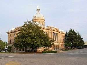 Clay County Courthouse in Ashland | |
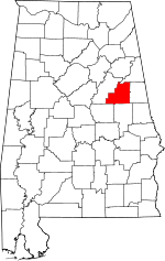 Location within the U.S. state of Alabama | |
 Alabama's location within the U.S. | |
| Coordinates: 33°16′20″N 85°51′40″W | |
| Country | |
| State | |
| Founded | December 7, 1866 |
| Named for | Henry Clay |
| Seat | Ashland |
| Largest city | Lineville |
| Area | |
| • Total | 606 sq mi (1,570 km2) |
| • Land | 604 sq mi (1,560 km2) |
| • Water | 2.0 sq mi (5 km2) 0.3%% |
| Population (2010) | |
| • Total | 13,932 |
| • Estimate (2019) | 13,235 |
| • Density | 23/sq mi (8.9/km2) |
| Time zone | UTC−6 (Central) |
| • Summer (DST) | UTC−5 (CDT) |
| Congressional district | 3rd |
| Website | alabamaclaycounty |
| |
History
Clay County was established on December 7, 1866, from land taken from Randolph and Talladega counties. Named after the famous statesman Henry Clay,[4] the county seat itself was named after his estate in Lexington, Kentucky called "Ashland". The county was covered with a heavy growth of trees, and a part of the territory was occupied by the Creek Indians. The early pioneers acquired the lands by government entry and the Indian lands by public auction. The families came wholly from Fayette County, Georgia.[5] Clay County was formed for geographic reasons. The citizens of the area had a difficult time reaching the county seat of Wedowee in Randolph County because of the Tallapoosa River to the east. Talladega was difficult to reach because of the intervening mountains. Even today, Clay County is one of only three counties in Alabama to have no U.S. highways in its boundaries. Ashland was a mining center, particularly for graphite.[6]
During the Desert Shield/Storm conflict, Clay County had more soldiers serving per capita than any other county in the United States.[7]
Geography
According to the U.S. Census Bureau, the county has a total area of 606 square miles (1,570 km2), of which 604 square miles (1,560 km2) is land and 2.0 square miles (5.2 km2) (0.3%) is water.[8]
Adjacent counties
- Cleburne County – north
- Randolph County – east
- Tallapoosa County – south
- Coosa County – southwest
- Talladega County – west
National protected area
- Talladega National Forest (part)
Transportation
Major highways


Demographics
| Historical population | |||
|---|---|---|---|
| Census | Pop. | %± | |
| 1870 | 9,560 | — | |
| 1880 | 12,938 | 35.3% | |
| 1890 | 15,765 | 21.9% | |
| 1900 | 17,099 | 8.5% | |
| 1910 | 21,006 | 22.8% | |
| 1920 | 22,645 | 7.8% | |
| 1930 | 17,768 | −21.5% | |
| 1940 | 16,907 | −4.8% | |
| 1950 | 13,929 | −17.6% | |
| 1960 | 12,400 | −11.0% | |
| 1970 | 12,636 | 1.9% | |
| 1980 | 13,703 | 8.4% | |
| 1990 | 13,252 | −3.3% | |
| 2000 | 14,254 | 7.6% | |
| 2010 | 13,932 | −2.3% | |
| Est. 2019 | 13,235 | [9] | −5.0% |
| U.S. Decennial Census[10] 1790–1960[11] 1900–1990[12] 1990–2000[13] 2010–2018[1] | |||
As of the census[14] of 2010, there were 13,932 people, 5,670 households, and 3,978 families residing in the county. The population density was 23 people per square mile (9/km2). There were 6,776 housing units at an average density of 11 per square mile (4/km2). The racial makeup of the county was 81.7% White (non-Hispanic), 14.8% Black or African American, 0.4% Native American, 0.2% Asian, 0.0% Pacific Islander, 1.2% from other races, and 1.7% from two or more races. 2.9% of the population were Hispanic or Latino of any race.
As of the census[14] of 2000, there were 14,254 people, 5,765 households, and 4,098 families residing in the county. The population density was 24 people per square mile (9/km2). There were 6,612 housing units at an average density of 11 per square mile (4/km2). The racial makeup of the county was 77.62% White (non-Hispanic), 19.70% Black or African American, 0.32% Native American, 0.10% Asian, 0.02% Pacific Islander, 0.46% from other races, and 0.79% from two or more races. 4.77% of the population were Hispanic or Latino of any race.
There were 5,670 households out of which 27.1% had children under the age of 18 living with them, 52.7% were married couples living together, 12.8% had a female householder with no husband present, and 29.8% were non-families. 27.2% of all households were made up of individuals and 11.8% had someone living alone who was 65 years of age or older. The average household size was 2.41 and the average family size was 2.92.
In the county, the population was spread out with 22.6% under the age of 18, 7.8% from 18 to 24, 23.8% from 25 to 44, 28.3% from 45 to 64, and 17.6% who were 65 years of age or older. The median age was 42 years. For every 100 females, there were 96.3 males. For every 100 females age 18 and over, there were 96.4 males.
The median income for a household in the county was $35,595, and the median income for a family was $43,392. Males had a median income of $32,382 versus $30,000 for females. The per capita income for the county was $18,332. About 18.5% of families and 18.8% of the population were below the poverty line, including 21.1% of those under age 18 and 15.4% of those age 65 or over.
Government
Clay County is governed by a five-member Board of Commissioners: Commissioner Morrison, Commissioner Harris, Commissioner Denny, Commissioner Milstead and Commissioner Burney. Within Clay County are two principal cities, Ashland and Lineville. The mayor of Ashland is Larry J. Fetner who works closely with five community members that run the city government, they are Billy Joe Smith for District 1, Bobbie Steed for District 2 he is also Mayor Pro Tem, Kim M. Cain for District 3, Annette F. Gaither for District 4, Tommy Cantrell for District 5.[15]
The second and smaller of the two cities is Lineville. The mayor is Roy Adamson and is also run by a five-member board. City Council members being as follows: Carolyn Smith for District 1, David Proctor for District 2, Joseph Appleby for District 3, Robert Milstead for District 4 and Johnny Appleby for District 5.[16]
Legislators for the county are Rep. Richard Laird for State of Alabama House, District 37. Sen. Gerald Dial State of Alabama Senate, District 13. The U.S. Representatives are Rep. Mike Rogers (R-AL), 3rd District, Sen. Doug Jones and Sen. Richard Shelby.[17]
| Year | GOP | Dem | Others |
|---|---|---|---|
| 2016 | 79.2% 5,245 | 18.7% 1,237 | 2.1% 142 |
| 2012 | 72.1% 4,817 | 26.6% 1,777 | 1.3% 85 |
| 2008 | 73.1% 4,984 | 25.8% 1,760 | 1.1% 75 |
| 2004 | 70.3% 4,624 | 28.8% 1,893 | 0.9% 59 |
| 2000 | 63.2% 3,719 | 34.8% 2,045 | 2.0% 119 |
| 1996 | 48.4% 2,694 | 41.4% 2,306 | 10.2% 568 |
| 1992 | 49.7% 2,859 | 36.0% 2,073 | 14.3% 823 |
| 1988 | 66.7% 3,496 | 30.6% 1,602 | 2.7% 140 |
| 1984 | 68.2% 3,432 | 28.9% 1,456 | 2.9% 145 |
| 1980 | 48.1% 2,764 | 49.7% 2,858 | 2.2% 125 |
| 1976 | 38.8% 1,883 | 60.6% 2,946 | 0.6% 29 |
| 1972 | 88.2% 3,948 | 11.3% 507 | 0.4% 19 |
| 1968 | 14.0% 706 | 5.1% 256 | 80.9% 4,082 |
| 1964 | 70.1% 2,815 | 29.9% 1,199 | |
| 1960 | 46.8% 1,548 | 52.7% 1,743 | 0.5% 16 |
| 1956 | 48.1% 1,597 | 50.5% 1,677 | 1.5% 49 |
| 1952 | 37.4% 1,183 | 62.3% 1,972 | 0.3% 9 |
| 1948 | 25.8% 387 | 74.2% 1,115 | |
| 1944 | 32.4% 741 | 67.0% 1,535 | 0.6% 14 |
| 1940 | 28.3% 854 | 71.2% 2,153 | 0.5% 16 |
| 1936 | 23.5% 700 | 71.8% 2,138 | 4.7% 140 |
| 1932 | 30.4% 931 | 68.7% 2,103 | 0.9% 28 |
| 1928 | 65.9% 1,889 | 34.1% 978 | 0.0% 1 |
| 1924 | 38.1% 1,017 | 59.9% 1,597 | 2.0% 53 |
| 1920 | 49.6% 2,133 | 50.3% 2,165 | 0.1% 3 |
| 1916 | 36.1% 677 | 63.7% 1,196 | 0.2% 4 |
| 1912 | 3.0% 64 | 52.5% 1,109 | 44.5% 941 |
| 1908 | 39.8% 594 | 57.8% 863 | 2.5% 37 |
| 1904 | 41.6% 990 | 56.5% 1,345 | 1.9% 44 |
Notable people
- Hugo Black (1886–1971), born in Harlan, served as an associate justice of the U.S. Supreme Court from 1937 until 1971
- Barney Lee Whatley (1885–1979), born on Idaho Rd, best friend and law partner of Hugo Black. Became a prominent Colorado attorney.
- LaFayette L. Patterson (1888–1987), born near Delta, served three terms in the U.S. Congress from 1928 to 1933
- Byron Lavoy Cockrell (1935–2007), born in Lineville, rocket scientist and engineer
- Kenneth F. Ingram (1929-2014), born in Ashland, Judge Alabama Court of Civil Appeals. Justice Alabama Supreme Court.
- Bob Riley (b. 1944), U.S. Congressman and Alabama's 52nd governor, native of Ashland
- Major General Flem Bowen Donnie Walker, Jr. (b. 1964), Deputy Commanding General, US Army Central Command, native of Lineville
Places of interest
Clay County is home to parts of Cheaha State Park in the Talladega National Forest and Lake Wedowee on the eastern boundary. Outdoor adventures abound in Clay County and the surrounding area. The Pinhoti Trail system[19] weaves its way through the Talladega National Forest to Mt. Cheaha, the highest point in Alabama. Hikers along the trail may spy some of the local wildlife, including whitetail deer, wild turkey, and the rare bald eagle.
Home of Doc Hilt Trails for Off-Highway Vehicles. On May 5, 2010, Doc Hilt Trails was awarded the distinction of being a National Recreation Trail.[20] One of only two private motorized parks in the nation to ever be awarded the NRT designation.
Clay County has two sites listed on the National Register of Historic Places, the Hugo Black House (destroyed, but still listed) and the Clay County Courthouse.[21]
See also
References
- "State & County QuickFacts". United States Census Bureau. Archived from the original on May 17, 2014. Retrieved May 15, 2014.
- "Find a County". National Association of Counties. Archived from the original on May 31, 2011. Retrieved June 7, 2011.
- "Alabama's last dry county legalizes alcohol sales". USA Today. Retrieved March 3, 2016.
- Gannett, Henry (1905). The Origin of Certain Place Names in the United States. Govt. Print. Off. pp. 83.
- History of Clay County, Alabama Ingram, Clanda Garrett 1966
- Graphite Deposits of Ashland, Alabama by John Stafford Brown, 1925
- Small Town Historic Markers, Alabama Tourism Department, archived from the original on February 3, 2011, retrieved February 2, 2011
- "2010 Census Gazetteer Files". United States Census Bureau. August 22, 2012. Retrieved August 22, 2015.
- "Population and Housing Unit Estimates". Retrieved May 21, 2019.
- "U.S. Decennial Census". United States Census Bureau. Retrieved August 22, 2015.
- "Historical Census Browser". University of Virginia Library. Retrieved August 22, 2015.
- Forstall, Richard L., ed. (March 24, 1995). "Population of Counties by Decennial Census: 1900 to 1990". United States Census Bureau. Retrieved August 22, 2015.
- "Census 2000 PHC-T-4. Ranking Tables for Counties: 1990 and 2000" (PDF). United States Census Bureau. April 2, 2001. Retrieved August 22, 2015.
- "U.S. Census website". United States Census Bureau. Retrieved May 14, 2011.
- "City of Ashland, AL". cityofashland. Retrieved June 23, 2018.
- "Welcome to Lineville". citysite. Retrieved June 23, 2018.
- "Alabama Members of Congress | ALSHRM State Council". al.shrm.org. Retrieved June 23, 2018.
- "Dave Leip's Atlas of U.S. Presidential Elections". Retrieved November 16, 2016.
- "The Pinhoti Trail - Alabama & Georgia". PureBound.com. 2012. Archived from the original on April 9, 2009. Retrieved July 16, 2012.
- "National Recreation Trail Database". AmericanTrails.org. 2012. Retrieved July 16, 2012.
- "National Register Information System". National Register of Historic Places. National Park Service. July 9, 2010.
Places adjacent to Clay County, Alabama | ||||||||||
|---|---|---|---|---|---|---|---|---|---|---|
| ||||||||||
Municipalities and communities of Clay County, Alabama, United States | ||
|---|---|---|
| City | Map of Alabama highlighting Clay County | |
| Town | ||
| CDPs | ||
| Unincorporated communities | ||
Montgomery (capital) | ||
| Topics | ||
| Society |
| |
| Regions | ||
| Flora and fauna | ||
| Largest cities | ||
| Metros |
| |
| Counties |
| |
| Authority control |
|
|---|