Crenshaw County, Alabama
Crenshaw County is a county located in the south central portion of the U.S. state of Alabama. It is located immediately south of the Montgomery metropolitan area. As of the 2010 census, the population was 13,906.[1] Its county seat is Luverne.[2] Its name is in honor of an Alabama judge, Anderson Crenshaw.
Crenshaw County | |
|---|---|
 Crenshaw County courthouse in Luverne | |
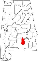 Location within the U.S. state of Alabama | |
 Alabama's location within the U.S. | |
| Coordinates: 31°43′41″N 86°18′36″W | |
| Country | |
| State | |
| Founded | November 30, 1866 |
| Named for | Anderson Crenshaw |
| Seat | Luverne |
| Largest city | Luverne |
| Area | |
| • Total | 611 sq mi (1,580 km2) |
| • Land | 609 sq mi (1,580 km2) |
| • Water | 2.1 sq mi (5 km2) 0.3%% |
| Population (2010) | |
| • Total | 13,906 |
| • Estimate (2019) | 13,772 |
| • Density | 23/sq mi (8.8/km2) |
| Time zone | UTC−6 (Central) |
| • Summer (DST) | UTC−5 (CDT) |
| Congressional district | 2nd |
| Website | crenshawcountyalonline.com |
| |
History
Crenshaw County was established after the American Civil War on November 30, 1866, by the Reconstruction era legislature. It was formed from parts of Butler, Coffee, Covington, Pike and Lowndes counties. While part of the coastal area, this county had relatively infertile soils, limiting cotton and other agriculture. Its planters used enslaved African Americans for all needed types of labor. Many of their descendants stayed in the area, and nearly one-quarter of the county population is African American.
Crenshaw County became a center of timbering in the Piney Wood region, especially after the Montgomery and Florida Railroad Company constructed a line through the county in 1886. This provided transport to markets for timber. It connected with Sprague Junction in Montgomery County, Alabama. The timber camps were rough work areas where racial tensions sometimes flared.
Geography
According to the U.S. Census Bureau, the county has a total area of 611 square miles (1,580 km2), of which 609 square miles (1,580 km2) is land and 2.1 square miles (5.4 km2) (0.3%) is water.[3] The county is located in the Gulf Coastal Plain region of the state. Much of the land is also covered by forests that are used for logging.
Major highways


Adjacent counties
- Montgomery County (north)
- Pike County (east)
- Coffee County (southeast)
- Covington County (south)
- Butler County (west)
- Lowndes County (northwest)
Demographics
| Historical population | |||
|---|---|---|---|
| Census | Pop. | %± | |
| 1870 | 11,156 | — | |
| 1880 | 11,726 | 5.1% | |
| 1890 | 15,425 | 31.5% | |
| 1900 | 19,668 | 27.5% | |
| 1910 | 23,313 | 18.5% | |
| 1920 | 23,017 | −1.3% | |
| 1930 | 23,656 | 2.8% | |
| 1940 | 23,631 | −0.1% | |
| 1950 | 18,981 | −19.7% | |
| 1960 | 14,909 | −21.5% | |
| 1970 | 13,188 | −11.5% | |
| 1980 | 14,110 | 7.0% | |
| 1990 | 13,635 | −3.4% | |
| 2000 | 13,665 | 0.2% | |
| 2010 | 13,906 | 1.8% | |
| Est. 2019 | 13,772 | [4] | −1.0% |
| U.S. Decennial Census[5] 1790–1960[6] 1900–1990[7] 1990–2000[8] 2010–2018[1] | |||
At the 2000 census there were 13,665 people, 5,577 households, and 3,892 families living in the county. The population density was 22 people per square mile (9/km2). There were 6,644 housing units at an average density of 11 per square mile (4/km2). The racial makeup of the county was 73.82% White, 24.79% Black or African American, 0.37% Native American, 0.11% Asian, 0.01% Pacific Islander, 0.20% from other races, and 0.70% from two or more races. 0.64% of the population were Hispanic or Latino of any race.[9] Of the 5,577 households 31.00% had children under the age of 18 living with them, 50.70% were married couples living together, 15.40% had a female householder with no husband present, and 30.20% were non-families. 28.20% of households were one person and 14.70% were one person aged 65 or older. The average household size was 2.42 and the average family size was 2.96.
The age distribution was 24.70% under the age of 18, 7.90% from 18 to 24, 26.30% from 25 to 44, 23.90% from 45 to 64, and 17.10% 65 or older. The median age was 39 years. For every 100 females there were 89.80 males. For every 100 females age 18 and over, there were 83.60 males.
The median household income was $26,054 and the median family income was $31,724. Males had a median income of $27,286 versus $17,703 for females. The per capita income for the county was $14,565. About 18.60% of families and 22.10% of the population were below the poverty line, including 28.30% of those under age 18 and 23.50% of those age 65 or over.
2010 census
At the 2010 census there were 13,906 people, 5,652 households, and 3,882 families living in the county. The population density was 23 people per square mile (9/km2). There were 6,735 housing units at an average density of 11 per square mile (4/km2). The racial makeup of the county was 72.6% White, 23.4% Black or African American, 0.4% Native American, 1.4% Asian, 0.1% Pacific Islander, 0.7% from other races, and 1.5% from two or more races. 1.5% of the population were Hispanic or Latino of any race.[10] Of the 5,652 households 27.3% had children under the age of 18 living with them, 48.7% were married couples living together, 15.6% had a female householder with no husband present, and 31.3% were non-families. 28.1% of households were one person and 11.9% were one person aged 65 or older. The average household size was 2.44 and the average family size was 2.97.
The age distribution was 23.8% under the age of 18, 8.0% from 18 to 24, 23.6% from 25 to 44, 28.7% from 45 to 64, and 15.9% 65 or older. The median age was 40.7 years. For every 100 females there were 93.4 males. For every 100 females age 18 and over, there were 95.3 males.
The median household income was $35,140 and the median family income was $47,685. Males had a median income of $35,598 versus $22,410 for females. The per capita income for the county was $19,793. About 13.7% of families and 17.7% of the population were below the poverty line, including 25.5% of those under age 18 and 16.7% of those age 65 or over.
The largest self-reported ancestry groups in Crenshaw County were English (64.5%), German (12.1%), Irish (11.2%), Italian (3.9%), "American" (3.1%), Scottish (2.9%) and Portuguese (1.8%).
Government
| Year | GOP | Dem | Others |
|---|---|---|---|
| 2016 | 72.0% 4,513 | 26.6% 1,664 | 1.4% 90 |
| 2012 | 67.4% 4,331 | 31.9% 2,050 | 0.7% 43 |
| 2008 | 68.7% 4,319 | 30.8% 1,938 | 0.5% 34 |
| 2004 | 68.7% 3,777 | 30.9% 1,698 | 0.5% 25 |
| 2000 | 58.3% 2,793 | 40.3% 1,934 | 1.4% 68 |
| 1996 | 43.6% 1,939 | 48.8% 2,172 | 7.6% 336 |
| 1992 | 44.2% 2,339 | 45.4% 2,404 | 10.3% 547 |
| 1988 | 58.4% 2,617 | 41.0% 1,836 | 0.6% 25 |
| 1984 | 61.9% 3,261 | 36.1% 1,904 | 2.0% 107 |
| 1980 | 47.2% 2,478 | 51.5% 2,704 | 1.4% 74 |
| 1976 | 34.2% 1,801 | 64.0% 3,372 | 1.8% 93 |
| 1972 | 72.9% 3,129 | 25.3% 1,085 | 1.9% 80 |
| 1968 | 3.8% 209 | 13.3% 726 | 82.9% 4,545 |
| 1964 | 78.7% 3,008 | 21.3% 816 | |
| 1960 | 16.4% 573 | 83.5% 2,923 | 0.1% 5 |
| 1956 | 19.1% 567 | 75.7% 2,252 | 5.2% 156 |
| 1952 | 17.9% 544 | 82.0% 2,485 | 0.1% 3 |
| 1948 | 2.7% 38 | 97.4% 1,394 | |
| 1944 | 5.6% 118 | 94.1% 1,980 | 0.3% 7 |
| 1940 | 3.0% 84 | 96.7% 2,680 | 0.3% 9 |
| 1936 | 3.9% 96 | 96.0% 2,371 | 0.2% 4 |
| 1932 | 5.3% 127 | 92.1% 2,200 | 2.6% 61 |
| 1928 | 42.7% 978 | 57.3% 1,314 | 0.0% 0 |
| 1924 | 9.4% 117 | 89.1% 1,107 | 1.5% 19 |
| 1920 | 17.9% 310 | 81.6% 1,411 | 0.5% 8 |
| 1916 | 8.8% 139 | 90.4% 1,427 | 0.8% 12 |
| 1912 | 4.0% 47 | 84.5% 986 | 11.5% 134 |
| 1908 | 20.9% 311 | 74.1% 1,100 | 5.0% 74 |
| 1904 | 13.3% 180 | 79.3% 1,077 | 7.5% 102 |
Communities
City
- Luverne (county seat)
Unincorporated communities
- Fullers Crossroads
- Highland Home
- Honoraville
- Lapine (partly in Montgomery County)
- Moodys Crossroads
- Mulberry
- Panola
- Social Town
- Theba
- Weedville
See also
References
- "State & County QuickFacts". United States Census Bureau. Archived from the original on May 17, 2014. Retrieved May 16, 2014.
- "Find a County". National Association of Counties. Archived from the original on May 31, 2011. Retrieved June 7, 2011.
- "2010 Census Gazetteer Files". United States Census Bureau. August 22, 2012. Retrieved August 22, 2015.
- "Population and Housing Unit Estimates". Retrieved May 21, 2019.
- "U.S. Decennial Census". United States Census Bureau. Retrieved August 22, 2015.
- "Historical Census Browser". University of Virginia Library. Retrieved August 22, 2015.
- Forstall, Richard L., ed. (March 24, 1995). "Population of Counties by Decennial Census: 1900 to 1990". United States Census Bureau. Retrieved August 22, 2015.
- "Census 2000 PHC-T-4. Ranking Tables for Counties: 1990 and 2000" (PDF). United States Census Bureau. April 2, 2001. Retrieved August 22, 2015.
- "U.S. Census website". United States Census Bureau. Retrieved May 14, 2011.
- "U.S. Census website". United States Census Bureau. Retrieved June 20, 2015.
- "Dave Leip's Atlas of U.S. Presidential Elections". Retrieved November 16, 2016.
Places adjacent to Crenshaw County, Alabama | ||||||||||
|---|---|---|---|---|---|---|---|---|---|---|
| ||||||||||
Municipalities and communities of Crenshaw County, Alabama, United States | ||
|---|---|---|
| Cities | Map of Alabama highlighting Crenshaw County | |
| Towns | ||
| Unincorporated communities | ||
| Footnotes | ‡This populated place also has portions in an adjacent county or counties | |
Montgomery (capital) | ||
| Topics | ||
| Society |
| |
| Regions | ||
| Flora and fauna | ||
| Largest cities | ||
| Metros |
| |
| Counties |
| |
| Authority control |
|
|---|