Conecuh County, Alabama
Conecuh County (/kəˈnɛkə/) is a county located in the south central portion of the U.S. state of Alabama. As of the 2010 census the population was 13,228.[1] Its county seat is Evergreen.[2] Its name is believed to be derived from a Creek Indian term meaning "land of cane."
Conecuh County | |
|---|---|
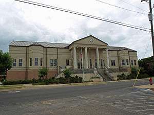 The Conecuh County Government Center in Evergreen | |
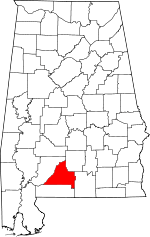 Location within the U.S. state of Alabama | |
 Alabama's location within the U.S. | |
| Coordinates: 31°25′32″N 86°59′38″W | |
| Country | |
| State | |
| Founded | February 13, 1818 |
| Seat | Evergreen |
| Largest city | Evergreen |
| Area | |
| • Total | 853 sq mi (2,210 km2) |
| • Land | 850 sq mi (2,200 km2) |
| • Water | 2.6 sq mi (7 km2) 0.3%% |
| Population (2010) | |
| • Total | 13,228 |
| • Estimate (2019) | 12,067 |
| • Density | 16/sq mi (6.0/km2) |
| Time zone | UTC−6 (Central) |
| • Summer (DST) | UTC−5 (CDT) |
| Congressional district | 2nd |
| |
History
The areas along the rivers had been used by varying cultures of indigenous peoples for thousands of years. French and Spanish explorers encountered the historic Creek Indians. Later, British colonial traders developed relationships with the Creek, and several married high-status Creek women. As the tribe has a matrilineal system, children are considered born into their mother's clan and take their status from her family.
During the American Revolutionary War, the Upper Creek chief Alexander McGillivray, whose father was Scottish, allied his tribe with the British, hoping they could stop colonial Americans from encroaching on Creek land. Commissioned a British colonel, McGillivray named Jean-Antoine Le Clerc, a French adventurer who lived with the Creeks for 20 years, as the war chief to lead the Creek warriors.
Conecuh County was established by Alabama on February 13, 1818. Some of its territory was taken in 1868 by the Republican state legislature during the Reconstruction era to establish Escambia County. Located in the coastal plain, 19th century Conecuh County was an area of plantations and cotton cultivation, and it is still quite rural today. Thousands of African American residents left in the 1940s, during the Second Great Migration, mostly for industrial regions in the major cities.
In September 1979, the county was declared a disaster area, due to damage caused by Hurricane Frederic.
Conecuh County was mentioned as the birthplace of Theodore Bagwell in the television series Prison Break.
Geography
According to the U.S. Census Bureau, the county has a total area of 853 square miles (2,210 km2), of which 850 square miles (2,200 km2) is land and 2.6 square miles (6.7 km2) (0.3%) is water.[3]
Major highways
.svg.png)


Adjacent counties
- Butler County (northeast)
- Covington County (southeast)
- Escambia County (south)
- Monroe County (northwest)
Demographics
| Historical population | |||
|---|---|---|---|
| Census | Pop. | %± | |
| 1820 | 5,713 | — | |
| 1830 | 7,444 | 30.3% | |
| 1840 | 8,197 | 10.1% | |
| 1850 | 9,322 | 13.7% | |
| 1860 | 11,311 | 21.3% | |
| 1870 | 9,574 | −15.4% | |
| 1880 | 12,605 | 31.7% | |
| 1890 | 14,594 | 15.8% | |
| 1900 | 17,514 | 20.0% | |
| 1910 | 21,433 | 22.4% | |
| 1920 | 24,593 | 14.7% | |
| 1930 | 25,429 | 3.4% | |
| 1940 | 25,489 | 0.2% | |
| 1950 | 21,776 | −14.6% | |
| 1960 | 17,762 | −18.4% | |
| 1970 | 15,645 | −11.9% | |
| 1980 | 15,884 | 1.5% | |
| 1990 | 14,054 | −11.5% | |
| 2000 | 14,089 | 0.2% | |
| 2010 | 13,228 | −6.1% | |
| Est. 2019 | 12,067 | [4] | −8.8% |
| U.S. Decennial Census[5] 1790–1960[6] 1900–1990[7] 1990–2000[8] 2010–2018[1] | |||
2010
According to the 2010 U.S. Census:
- 51.3% White
- 46.5% Black
- 0.3% Native American
- 0.1% Asian
- 0.0% Native Hawaiian or Pacific Islander
- 1.0% Two or more races
- 1.2% Hispanic or Latino (of any race)
2000
As of the census[9] of 2000, there were 14,089 people, 5,792 households, and 3,938 families residing in the county. The population density was 17 people per square mile (6/km2). There were 7,265 housing units at an average density of 8 per square mile (3/km2). The racial makeup of the county was 55.40% White, 43.55% Black or African American, 0.20% Native American, 0.11% Asian, 0.05% Pacific Islander, 0.09% from other races, and 0.60% from two or more races. 0.72% of the population were Hispanic or Latino of any race.
There were 5,792 households out of which 30.90% had children under the age of 18 living with them, 47.70% were married couples living together, 16.20% had a female householder with no husband present, and 32.00% were non-families. 30.10% of all households were made up of individuals and 13.50% had someone living alone who was 65 years of age or older. The average household size was 2.42 and the average family size was 3.01.
In the county, the population was spread out with 25.90% under the age of 18, 8.30% from 18 to 24, 25.80% from 25 to 44, 24.30% from 45 to 64, and 15.80% who were 65 years of age or older. The median age was 38 years. For every 100 females there were 89.80 males. For every 100 females age 18 and over, there were 84.30 males.
The median income for a household in the county was $22,111, and the median income for a family was $31,424. Males had a median income of $28,115 versus $19,350 for females. The per capita income for the county was $12,964. About 21.70% of families and 26.60% of the population were below the poverty line, including 36.10% of those under age 18 and 28.90% of those age 65 or over.
Government
Conecuh is a swing county in presidential elections; since 1972 it has voted for both parties an equal number of times.
| Year | GOP | Dem | Others |
|---|---|---|---|
| 2016 | 51.9% 3,420 | 46.8% 3,080 | 1.3% 85 |
| 2012 | 49.0% 3,439 | 50.6% 3,555 | 0.4% 31 |
| 2008 | 50.0% 3,470 | 49.4% 3,429 | 0.6% 44 |
| 2004 | 54.3% 3,271 | 45.2% 2,719 | 0.5% 31 |
| 2000 | 48.6% 2,699 | 50.1% 2,783 | 1.2% 69 |
| 1996 | 38.3% 2,093 | 53.2% 2,903 | 8.5% 465 |
| 1992 | 39.1% 2,463 | 50.0% 3,155 | 10.9% 689 |
| 1988 | 51.2% 3,256 | 47.5% 3,022 | 1.2% 79 |
| 1984 | 55.9% 3,538 | 43.2% 2,735 | 1.0% 61 |
| 1980 | 47.7% 2,948 | 50.2% 3,102 | 2.1% 131 |
| 1976 | 36.4% 1,812 | 62.0% 3,086 | 1.7% 82 |
| 1972 | 74.8% 3,214 | 24.3% 1,042 | 0.9% 40 |
| 1968 | 3.5% 186 | 21.5% 1,151 | 75.0% 4,009 |
| 1964 | 81.3% 2,782 | 18.7% 639 | |
| 1960 | 25.8% 650 | 72.2% 1,815 | 2.0% 50 |
| 1956 | 32.1% 885 | 61.3% 1,687 | 6.6% 182 |
| 1952 | 30.5% 749 | 68.3% 1,678 | 1.3% 31 |
| 1948 | 4.5% 64 | 95.5% 1,345 | |
| 1944 | 7.7% 127 | 91.3% 1,498 | 0.9% 15 |
| 1940 | 2.1% 50 | 97.7% 2,345 | 0.2% 5 |
| 1936 | 3.9% 89 | 95.6% 2,195 | 0.5% 12 |
| 1932 | 5.1% 114 | 94.9% 2,125 | 0.0% 0 |
| 1928 | 56.5% 1,113 | 43.5% 858 | 0.0% 0 |
| 1924 | 8.5% 92 | 88.1% 955 | 3.4% 37 |
| 1920 | 12.6% 189 | 87.4% 1,315 | 0.0% 0 |
| 1916 | 3.8% 42 | 94.4% 1,036 | 1.7% 19 |
| 1912 | 6.1% 60 | 80.9% 802 | 13.0% 129 |
| 1908 | 13.9% 111 | 81.8% 651 | 4.3% 34 |
| 1904 | 12.3% 106 | 85.4% 739 | 2.3% 20 |
Communities
City
- Evergreen (county seat)
Towns
- Castleberry
- McKenzie (partly in Butler County)
- Repton
Unincorporated communities
Historic sites
Conecuh County has three sites listed on the National Register of Historic Places, the Asa Johnston Farmhouse, Louisville and Nashville Depot, and New Evergreen Commercial Historic District.[11]
See also
References
- "State & County QuickFacts". United States Census Bureau. Archived from the original on May 17, 2014. Retrieved May 16, 2014.
- "Find a County". National Association of Counties. Archived from the original on May 31, 2011. Retrieved June 7, 2011.
- "2010 Census Gazetteer Files". United States Census Bureau. August 22, 2012. Retrieved August 22, 2015.
- "Population and Housing Unit Estimates". Retrieved May 17, 2019.
- "U.S. Decennial Census". United States Census Bureau. Retrieved August 22, 2015.
- "Historical Census Browser". University of Virginia Library. Retrieved August 22, 2015.
- Forstall, Richard L., ed. (March 24, 1995). "Population of Counties by Decennial Census: 1900 to 1990". United States Census Bureau. Retrieved August 22, 2015.
- "Census 2000 PHC-T-4. Ranking Tables for Counties: 1990 and 2000" (PDF). United States Census Bureau. April 2, 2001. Retrieved August 22, 2015.
- "U.S. Census website". United States Census Bureau. Retrieved 2008-01-31.
- "Dave Leip's Atlas of U.S. Presidential Elections". Retrieved November 15, 2016.
- "National Register Information System". National Register of Historic Places. National Park Service. July 9, 2010.
External links
- Coastal Gateway Regional Economic Development Alliance
- B.F. Riley, History of Conecuh County, (1881)
- The Monthly View Newspaper
Places adjacent to Conecuh County, Alabama | ||||||||||
|---|---|---|---|---|---|---|---|---|---|---|
| ||||||||||
Municipalities and communities of Conecuh County, Alabama, United States | ||
|---|---|---|
| City | Map of Alabama highlighting Conecuh County | |
| Towns | ||
| Unincorporated communities | ||
| Footnotes | ‡This populated place also has portions in an adjacent county or counties | |
Montgomery (capital) | ||
| Topics | ||
| Society |
| |
| Regions | ||
| Flora and fauna | ||
| Largest cities | ||
| Metros |
| |
| Counties |
| |
| Authority control |
|
|---|