Lauderdale County, Alabama
Lauderdale County is a county located in the northwestern corner of the U.S. state of Alabama. As of the 2010 census the population was 92,709.[2] Its county seat is Florence.[3] Its name is in honor of Colonel James Lauderdale, of Tennessee.
Lauderdale County | |
|---|---|
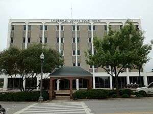 Lauderdale County Courthouse in Florence | |
 Location within the U.S. state of Alabama | |
 Alabama's location within the U.S. | |
| Coordinates: 34°53′57″N 87°39′01″W | |
| Country | |
| State | |
| Founded | February 6, 1818[1] |
| Named for | James Lauderdale |
| Seat | Florence |
| Largest city | Florence |
| Area | |
| • Total | 721 sq mi (1,870 km2) |
| • Land | 668 sq mi (1,730 km2) |
| • Water | 53 sq mi (140 km2) 7.4%% |
| Population (2010) | |
| • Total | 92,709 |
| • Estimate (2019) | 92,729 |
| • Density | 130/sq mi (50/km2) |
| Time zone | UTC−6 (Central) |
| • Summer (DST) | UTC−5 (CDT) |
| Congressional district | 5th |
| Website | https://lauderdalecountyal.gov/ |
| |
Lauderdale is part of the Florence-Muscle Shoals, AL Metropolitan Statistical Area, also known as "The Shoals".
History
Lauderdale County was named in honor of Col. James Lauderdale[4] who was born in Virginia about 1780. In the early 19th century, Lauderdale, who moved to West Tennessee, became a major in General John Coffee's cavalry of volunteers. Later promoted to Lieutenant Colonel, he commanded a brigade of mounted riflemen, serving under Andrew Jackson in many battles against the Indians. According to reliable historians, Col. Lauderdale did not die in the Battle of New Orleans, but was wounded in the Battle of Talladega and died on December 23, 1814, seventeen days before Jackson's crushing defeat of the British at New Orleans. Several towns and counties in the southern states were named in his honor, though it is said that he never set foot in Lauderdale County.
Lauderdale County was established in 1818,[1] a year before Alabama became a state. Florence, the county seat of Lauderdale County, was also established in 1818. At this time a group of investors, under the name of Cypress Land Company purchased from the government 5,515 acres (22.32 km2) of land consisting of the original town site. Other towns in Lauderdale County competing for early settlers because of their proximity to the river were Savage's Spring, nine miles (14 km) below Florence and Waterloo, some 20 miles (32 km) downriver.
Among the older settlements in the county is Center Star, located between Killen and Rogersville. This area was once claimed by both the Chickasaws and Cherokees, necessitating a cession of territory from each tribe before the settlement could be established. At one time, the remains of an old Indian village could be seen southwest of Center Star. Other old settlements included Middleton and Elgin, the latter known first as Ingram's Elgin Cross Roads.
Rogersville, lying some 23 miles (37 km) to the east of Florence, was named for John Rogers, an Indian trader, whose sons were fast friends of the great Sam Houston. The late Will Rogers is said to have been a descendant of this same family. An early ferry that operated for many years was Lamb's Ferry near Rogersville.
Lexington, Springfield, and Anderson lie to the north of the Lee Highway, the town of Lexington being a part of the territory once claimed by the Cherokee. Many of the settlers of that area came from Tennessee and the Carolinas. The first post office of record at Lexington was on the Loretto Road, north of town, in 1880. Mail at that time was brought in from Loretto, Tennessee, by horseback and carts.
The town of St. Florian was established in 1872 on the Jackson Highway and named by its German Catholic founders for their patron saint.
Four Alabama governors were from the county - Hugh McVay, Robert M. Patton, Edward A. O'Neal and Emmett O'Neal.[5]
Geography
According to the U.S. Census Bureau, the county has a total area of 721 square miles (1,870 km2), of which 668 square miles (1,730 km2) is land and 53 square miles (140 km2) (7.4%) is water.[6]
National protected areas
Rivers
- Tennessee River
- Elk River
Adjacent counties
- Wayne County, Tennessee - north
- Lawrence County, Tennessee - north
- Giles County, Tennessee - northeast
- Limestone County - east
- Lawrence County - southeast
- Colbert County - south
- Tishomingo County, Mississippi - west
- Hardin County, Tennessee - northwest
Demographics
| Historical population | |||
|---|---|---|---|
| Census | Pop. | %± | |
| 1820 | 4,963 | — | |
| 1830 | 11,781 | 137.4% | |
| 1840 | 14,485 | 23.0% | |
| 1850 | 17,172 | 18.6% | |
| 1860 | 17,420 | 1.4% | |
| 1870 | 15,091 | −13.4% | |
| 1880 | 21,035 | 39.4% | |
| 1890 | 23,739 | 12.9% | |
| 1900 | 26,559 | 11.9% | |
| 1910 | 30,936 | 16.5% | |
| 1920 | 39,556 | 27.9% | |
| 1930 | 41,130 | 4.0% | |
| 1940 | 46,230 | 12.4% | |
| 1950 | 54,179 | 17.2% | |
| 1960 | 61,622 | 13.7% | |
| 1970 | 68,111 | 10.5% | |
| 1980 | 80,546 | 18.3% | |
| 1990 | 79,661 | −1.1% | |
| 2000 | 87,966 | 10.4% | |
| 2010 | 92,709 | 5.4% | |
| Est. 2019 | 92,729 | [7] | 0.0% |
| U.S. Decennial Census[8] 1790–1960[9] 1900–1990[10] 1990–2000[11] 2010–2018[2] | |||
2010
According to the 2010 United States Census:
- 86.4% White
- 10.0% Black
- 0.4% Native American
- 0.7% Asian
- 0.0% Native Hawaiian or Pacific Islander
- 1.4% Two or more races
- 2.2% Hispanic or Latino (of any race)
2000
As of the census[12] of 2000, there were 87,966 people, 36,088 households, and 25,153 families residing in the county. The population density was 131 people per square mile (51/km2). There were 40,424 housing units at an average density of 60 per square mile (23/km2). The racial makeup of the county was 84.38% White or European American, 13.85% Black or African American, 0.25% Native American, 0.35% Asian, 0.02% Pacific Islander, 0.36% from other races, and 0.79% from two or more races. 1.02% of the population were Hispanic or Latino of any race.
In 2005 87.8% of the county population was non-Hispanic whites. African Americans were 11.7% of the population and Latinos 1.2% of the population.
According to the census[13] of 2000, the largest ancestry groups in Lauderdale County were English 41.9%, African 13.85%, Scots-Irish 9.66%, Scottish 4.11%, Irish 3.19% and Welsh 2.5%
In 2000 there were 36,088 households out of which 30.40% had children under the age of 18 living with them, 55.80% were married couples living together, 10.80% had a female householder with no husband present, and 30.30% were non-families. 26.40% of all households were made up of individuals and 11.00% had someone living alone who was 65 years of age or older. The average household size was 2.39 and the average family size was 2.89.
In the county, the population was spread out with 23.00% under the age of 18, 10.10% from 18 to 24, 27.90% from 25 to 44, 23.90% from 45 to 64, and 15.10% who were 65 years of age or older. The median age was 38 years. For every 100 females, there were 91.70 males. For every 100 females age 18 and over, there were 88.20 males.
The median income for a household in the county was $33,354, and the median income for a family was $41,438. Males had a median income of $33,943 versus $20,804 for females. The per capita income for the county was $18,626. About 10.50% of families and 14.40% of the population were below the poverty line, including 18.50% of those under age 18 and 11.30% of those age 65 or over.
Transportation
Major highways


Points of interest
Lauderdale County is home to the W. C. Handy Home and Museum and the Rosenbaum House.
Recreation
- Joe Wheeler State Park
- North Alabama Birding Trail - collection of birdwatching areas.
- Natchez Trace Parkway - 444 miles (715 km) of linear park and roadway that travel from Nashville, Tennessee to Natchez, Mississippi. It has road pull-offs with educational kiosks with information about the land, history, and native species.
- Shoal Creek Preserve Tract - a 298 acres (121 ha) tract for the preservation of native plants and animals. Also, the land has recreational opportunities, including bird watching, a horse trail loop that is 2.1 miles (3.4 km) long, 4.2 miles (6.8 km) of hiking trails and limited hunting.[14] This tract is located north of St. Florian, Alabama.
Government
| Year | GOP | Dem | Others |
|---|---|---|---|
| 2016 | 70.6% 27,899 | 25.2% 9,952 | 4.2% 1,674 |
| 2012 | 64.6% 23,911 | 33.8% 12,511 | 1.7% 610 |
| 2008 | 63.2% 24,068 | 35.0% 13,329 | 1.9% 707 |
| 2004 | 59.7% 22,161 | 39.4% 14,628 | 0.9% 318 |
| 2000 | 54.4% 17,478 | 43.2% 13,875 | 2.4% 784 |
| 1996 | 46.2% 14,058 | 44.8% 13,619 | 9.1% 2,759 |
| 1992 | 40.7% 13,728 | 47.2% 15,936 | 12.1% 4,092 |
| 1988 | 49.4% 12,942 | 49.1% 12,862 | 1.4% 376 |
| 1984 | 53.6% 15,354 | 45.0% 12,907 | 1.4% 398 |
| 1980 | 38.4% 10,467 | 56.5% 15,379 | 5.1% 1,397 |
| 1976 | 31.2% 7,226 | 67.1% 15,549 | 1.8% 410 |
| 1972 | 71.7% 14,410 | 25.4% 5,112 | 2.9% 586 |
| 1968 | 15.6% 2,952 | 11.5% 2,166 | 72.9% 13,765 |
| 1964 | 47.6% 5,978 | 52.5% 6,593 | |
| 1960 | 29.2% 3,570 | 70.1% 8,565 | 0.7% 84 |
| 1956 | 21.0% 2,458 | 78.3% 9,150 | 0.7% 84 |
| 1952 | 21.2% 1,910 | 78.6% 7,097 | 0.2% 20 |
| 1948 | 14.3% 546 | 85.7% 3,276 | |
| 1944 | 12.8% 590 | 86.8% 4,001 | 0.4% 20 |
| 1940 | 9.0% 507 | 90.4% 5,065 | 0.6% 34 |
| 1936 | 7.6% 390 | 91.4% 4,685 | 1.0% 50 |
| 1932 | 11.4% 432 | 88.0% 3,336 | 0.6% 21 |
| 1928 | 33.8% 1,410 | 66.2% 2,763 | 0.0% 1 |
| 1924 | 25.9% 823 | 71.3% 2,266 | 2.8% 89 |
| 1920 | 30.1% 1,164 | 68.3% 2,644 | 1.6% 62 |
| 1916 | 17.5% 369 | 79.6% 1,678 | 2.9% 60 |
| 1912 | 13.0% 263 | 68.7% 1,386 | 18.3% 369 |
| 1908 | 26.1% 427 | 71.9% 1,177 | 2.0% 33 |
| 1904 | 19.7% 316 | 79.0% 1,269 | 1.3% 21 |
Education
Lauderdale County School District serves areas outside of Florence, while Florence City Schools serves people in Florence itself.
Communities

City
- Florence (county seat)
Towns
- Anderson
- Killen
- Lexington
- Rogersville
- St. Florian
- Waterloo
Census-designated place
Unincorporated communities
See also
References
- A digest of the laws of the State of Alabama: containing the statutes and resolutions in force at the end of the General Assembly in January, 1823. Published by Ginn & Curtis, J. & J. Harper, Printers, New-York, 1828. Title 10. Chapter XII. Pages 85. An Act to establish the western and southern Boundaries of Madison County, and to establish the Counties of Limestone and Lauderdale--Passed February 6, 1818.
- "State & County QuickFacts". United States Census Bureau. Archived from the original on June 24, 2011. Retrieved May 16, 2014.
- "Find a County". National Association of Counties. Retrieved June 7, 2011.
- Gannett, Henry (1905). The Origin of Certain Place Names in the United States. U.S. Government Printing Office. p. 182.
- "The History of Lauderdale County". Lauderdale County, Alabama Government. Retrieved 21 March 2012.
- "2010 Census Gazetteer Files". United States Census Bureau. August 22, 2012. Retrieved August 22, 2015.
- "Population and Housing Unit Estimates". Retrieved May 16, 2019.
- "U.S. Decennial Census". United States Census Bureau. Retrieved August 22, 2015.
- "Historical Census Browser". University of Virginia Library. Retrieved August 22, 2015.
- Forstall, Richard L., ed. (March 24, 1995). "Population of Counties by Decennial Census: 1900 to 1990". United States Census Bureau. Retrieved August 22, 2015.
- "Census 2000 PHC-T-4. Ranking Tables for Counties: 1990 and 2000" (PDF). United States Census Bureau. April 2, 2001. Retrieved August 22, 2015.
- "U.S. Census website". United States Census Bureau. Retrieved May 14, 2011.
- "U.S. Census website". United States Census Bureau. Retrieved January 31, 2008.
- "26. The Shoal Creek Preserve Tract". Forever Wild Program Land Tracts. Outdoor Alabama: Alabama Department of Conservation and Natural Resources. Archived from the original on February 11, 2012. Retrieved 19 March 2012.
- "Dave Leip's Atlas of U.S. Presidential Elections". Retrieved November 21, 2016.
Further reading
- William Lindsey McDonald (2003). A Walk Through the Past: People and Places of Florence and Lauderdale County, Alabama. Heart of Dixie Publishing. ISBN 978-0-9719945-6-0.
External links
| Wikimedia Commons has media related to Lauderdale County, Alabama. |
Places adjacent to Lauderdale County, Alabama | |
|---|---|
Municipalities and communities of Lauderdale County, Alabama, United States | ||
|---|---|---|
| Cities | Map of Alabama highlighting Lauderdale County | |
| Towns |
| |
| CDPs | ||
| Unincorporated communities | ||
Montgomery (capital) | ||
| Topics | ||
| Society |
| |
| Regions | ||
| Flora and fauna | ||
| Largest cities | ||
| Metros |
| |
| Counties |
| |
| Authority control |
|
|---|