Tampico, Illinois
Tampico /ˈtæm.pɪ.koʊ/ is a village located in Tampico Township, Whiteside County, Illinois, United States next to Rock Falls and Sterling IL. As of the 2010 census the village had a total population of 790, up from 772 at the 2000 census. It is known as the birthplace of Ronald Reagan, the 40th President of the United States.
Tampico | |
|---|---|
Village | |
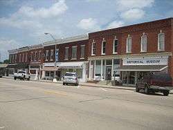 The Main Street Historic District in downtown Tampico | |
 Location of Tampico in Whiteside County, Illinois | |
.svg.png) Location of Illinois in the United States | |
| Coordinates: 41°37′50″N 89°47′07″W | |
| Country | United States |
| State | Illinois |
| County | Whiteside |
| Township | Tampico |
| Founded | 1875 |
| Area | |
| • Total | 0.39 sq mi (1.00 km2) |
| • Land | 0.39 sq mi (1.00 km2) |
| • Water | 0.00 sq mi (0.00 km2) |
| Elevation | 640 ft (200 m) |
| Population (2010) | |
| • Total | 790 |
| • Estimate (2018)[2] | 735 |
| • Density | 1,932.99/sq mi (746.98/km2) |
| Time zone | UTC-6 (CST) |
| • Summer (DST) | UTC-5 (CDT) |
| ZIP code | 61283 |
| Area code(s) | 815, 779 |
| FIPS code | 17-74470 |
| Wikimedia Commons | Tampico, Illinois |
| Website | www |
History
The area containing the future Tampico township was a slough. The first nonaboriginal settlers arrived in 1852. The township of Tampico was established in 1861. In 1863-64, the area was drained. The local railroad CB&Q went into service in 1871 and was taken out in the early 80s. In June 1874, a tornado struck, destroying 27 buildings. In 1875, the village of Tampico was incorporated.[3]
Geography

Tampico is located at 41°37′50″N 89°47′07″W (41.6304686 -89.7853130).[4] Its elevation is 640 ft (200 m).
According to the 2010 census, Tampico has a total area of 0.39 square miles (1.01 km2), all land.[5] About 1 mi (1.6 km) east of Tampico is the Hennepin Canal feeder.
Tampico is located about 40 mi (64 km) east-northeast of Moline and approximately 110 mi (180 km) west of Chicago.
Demographics
| Historical population | |||
|---|---|---|---|
| Census | Pop. | %± | |
| 1880 | 424 | — | |
| 1890 | 429 | 1.2% | |
| 1900 | 807 | 88.1% | |
| 1910 | 849 | 5.2% | |
| 1920 | 788 | −7.2% | |
| 1930 | 693 | −12.1% | |
| 1940 | 727 | 4.9% | |
| 1950 | 760 | 4.5% | |
| 1960 | 790 | 3.9% | |
| 1970 | 838 | 6.1% | |
| 1980 | 966 | 15.3% | |
| 1990 | 833 | −13.8% | |
| 2000 | 772 | −7.3% | |
| 2010 | 790 | 2.3% | |
| Est. 2018 | 735 | [2] | −7.0% |
| U.S. Decennial Census[6] | |||
At the 2000 census there were 772 people, 292 households, and 205 families in the village. The population density was 1,941.3 inhabitants per square mile (749.5/km2). There were 315 housing units at an average density of 792.1 per square mile (305.8/km2). The racial makeup of the village was 99.74% White, 0.00% Black, 0.00% Native American, 0.00% Asian, 0.00% Pacific Islander, 0.13% from other races, and 0.13% from two or more races. 1.55% of the population were Hispanic or Latino of any race.[7]

There were 292 households, 33.2% had children under the age of 18 living with them, 57.2% were married couples living together, 9.2% had a female householder with no husband present, and 29.5% were non-families. 24.7% of households were one person and 13.0% were one person aged 65 or older. The average household size was 2.64 and the average family size was 3.10.
The age distribution was 28.9% under the age of 18, 7.9% from 18 to 24, 26.2% from 25 to 44, 23.6% from 45 to 64, and 13.5% 65 or older. The median age was 36 years. For every 100 females, there were 102.1 males. For every 100 females age 18 and over, there were 102.6 males.
The median household income was $40,221 and the median family income is $43,646. Males had a median income of $30,667 versus $18,409 for females. The per capita income for the village was $14,467. 8.5% of the population and 6.4% of families were below the poverty line. Out of the total population, 10.2% of those under the age of 18 and 4.6% of those 65 and older were living below the poverty line.
Notable people
- Hazel A. McCaskrin, Illinois state legislator; born in Tampico
- Ronald Reagan, 40th President of the United States; born February 6, 1911 in Tampico
- Joseph M. Reeves, U.S. Navy Admiral and veteran of the Spanish–American War, World War I and World War II, born in Tampico
See also
References
- "2016 U.S. Gazetteer Files". United States Census Bureau. Retrieved Jun 30, 2017.
- "Population and Housing Unit Estimates". Retrieved September 19, 2019.
- Portrait and Biographical Album of Whiteside County, 1885
- "US Gazetteer files: 2010, 2000, and 1990". United States Census Bureau. 2011-02-12. Retrieved 2011-04-23.
- "G001 - Geographic Identifiers - 2010 Census Summary File 1". United States Census Bureau. Archived from the original on 2020-02-13. Retrieved 2015-12-25.
- "Census of Population and Housing". Census.gov. Retrieved June 4, 2015.
- "U.S. Census website". United States Census Bureau. Retrieved 2008-01-31.
External links
Municipalities and communities of Whiteside County, Illinois, United States | ||
|---|---|---|
| Cities | Map of Illinois highlighting Whiteside County | |
| Villages | ||
| Townships | ||
| CDP | ||
| Other unincorporated communities |
| |


| Authority control |
|
|---|