Park Ridge, Illinois
Park Ridge is a city in Cook County, Illinois, United States, and a Chicago suburb. The population was 37,480 at the 2010 census. It is located 15 miles (24 km) northwest of downtown Chicago. It is close to O'Hare International Airport, major expressways, and rail transportation. It is a part of the Chicago metropolitan area, bordering three northwestern neighborhoods of Chicago's Far North Side (Edison Park, Norwood Park, and O'Hare.)
Park Ridge, Illinois | |
|---|---|
| City of Park Ridge | |
 | |
 Location of Park Ridge in Cook County, Illinois. | |
| Coordinates: 42°0′43″N 87°50′30″W | |
| Country | United States |
| State | Illinois |
| County | Cook |
| Township | Maine, Leyden, Norwood Park |
| Incorporated | 1873 |
| Government | |
| • Type | Council–manager |
| • Mayor | Marty Malone |
| • Budget | $47,684,900 (2004-2005) (fiscal year: 2006-07) |
| Area | |
| • Total | 7.13 sq mi (18.48 km2) |
| • Land | 7.09 sq mi (18.35 km2) |
| • Water | 0.05 sq mi (0.12 km2) 0.56% |
| Population | |
| • Total | 37,480 |
| • Estimate (2019)[3] | 36,950 |
| • Density | 5,291.56/sq mi (2,042.95/km2) |
| Down 0.8% from 2000 | |
| Demonym(s) | Park Ridgian |
| ZIP code(s) | 60068 |
| Area code(s) | 847, 224 |
| FIPS code | 17-57875 |
| Website | www |
As its name suggests, Park Ridge lies on a ridge. The soil is abundant with clay deposits, which made it a brick-making center for the developing city of Chicago. Park Ridge was originally called Pennyville to honor George Penny, the businessman who owned the local brickyard along with Robert Meacham. Later it was named Brickton.[4] The Des Plaines River divides Park Ridge from neighboring Des Plaines, Illinois, which is west of Park Ridge. Chicago is south and east of Park Ridge, and Niles and unincorporated Maine Township are to its north.[5]
History
The area of Park Ridge was inhabited by the Potawatomie until they were removed in 1833. The area was a convenient portage between the Des Plaines and Chicago rivers for the French explorers and in the early 1830s, the first settlers arrived from New England and New York. In 1854 George Penny established a brickworks in the area. In 1910 Park Ridge had a population of 2,009. In 1930 the population was 10,417. In 1950 the population was 16,602. In 1960 the population was 32,625, with 99.9% of the population white. There were five African-Americans and 31 people classed other than black or white. By 1970, the population had risen to 42,466.[6] In 2016, former First Lady Hillary Rodham Clinton campaigned as the Democratic candidate for President of the United States. She was a graduate of the first class of Park Ridge's Maine Township High School South (1965).[7]
Geography
According to the 2010 census, Park Ridge has a total area of 7.134 square miles (18.48 km2), of which 7.09 square miles (18.36 km2) (or 99.38%) is land and 0.044 square miles (0.11 km2) (or 0.62%) is water.[8]
Climate
Park Ridge falls under the USDA 5b Plant Hardiness zone.[9]
| Climate data for Park Ridge, Illinois | |||||||||||||
|---|---|---|---|---|---|---|---|---|---|---|---|---|---|
| Month | Jan | Feb | Mar | Apr | May | Jun | Jul | Aug | Sep | Oct | Nov | Dec | Year |
| Record high °F (°C) | 67.0 (19.4) |
75.0 (23.9) |
88.0 (31.1) |
91.0 (32.8) |
98.0 (36.7) |
104.0 (40.0) |
105.0 (40.6) |
102.0 (38.9) |
101.0 (38.3) |
94.0 (34.4) |
81.0 (27.2) |
71.0 (21.7) |
105.0 (40.6) |
| Average high °F (°C) | 30 (−1) |
35 (2) |
46 (8) |
58 (14) |
70 (21) |
79 (26) |
84 (29) |
81 (27) |
74 (23) |
62 (17) |
47 (8) |
34 (1) |
58 (15) |
| Average low °F (°C) | 14 (−10) |
19 (−7) |
29 (−2) |
38 (3) |
47 (8) |
63 (17) |
62 (17) |
54 (12) |
42 (6) |
42 (6) |
32 (0) |
20 (−7) |
39 (4) |
| Record low °F (°C) | −27.0 (−32.8) |
−21.0 (−29.4) |
−12.0 (−24.4) |
7.0 (−13.9) |
27.0 (−2.8) |
35.0 (1.7) |
45.0 (7.2) |
42.0 (5.6) |
29.0 (−1.7) |
14.0 (−10.0) |
−2.0 (−18.9) |
−25.0 (−31.7) |
−27.0 (−32.8) |
| Average precipitation inches (mm) | 1.73 (44) |
1.87 (47) |
2.50 (64) |
3.38 (86) |
3.68 (93) |
3.45 (88) |
3.7 (94) |
4.9 (120) |
3.21 (82) |
3.15 (80) |
3.15 (80) |
2.25 (57) |
33.82 (859) |
| Source: <Park Ridge, Illinois Weather= >weather.com. "Park Ridge, Illinois Weather". Park Ridge, Illinois Weather Data. Open Publishing. Retrieved February 24, 2014. | |||||||||||||
Demographics
| Historical population | |||
|---|---|---|---|
| Census | Pop. | %± | |
| 1880 | 457 | — | |
| 1890 | 987 | 116.0% | |
| 1900 | 1,340 | 35.8% | |
| 1910 | 2,009 | 49.9% | |
| 1920 | 3,383 | 68.4% | |
| 1930 | 10,417 | 207.9% | |
| 1940 | 12,063 | 15.8% | |
| 1950 | 16,602 | 37.6% | |
| 1960 | 32,659 | 96.7% | |
| 1970 | 42,614 | 30.5% | |
| 1980 | 38,704 | −9.2% | |
| 1990 | 36,175 | −6.5% | |
| 2000 | 37,775 | 4.4% | |
| 2010 | 37,480 | −0.8% | |
| Est. 2019 | 36,950 | [3] | −1.4% |
| U.S. Decennial Census[10] | |||

| Demographics (2010)[11] | |||
|---|---|---|---|
| White | Black | Asian | |
| 93.4% | 0.5% | 3.7% | |
| Islander | Native | Other | Hispanic (any race) |
| 0.01% | 0.1% | 1.3% | 4.7% |
As of the census[12] of 2000, there were 37,775 people, 14,219 households, and 10,465 families residing in the city. The population density was 5,374.6 people per square mile (2,074.7/km2). There were 14,646 housing units at an average density of 2,083.8 per square mile (804.4/km2). The racial makeup of the city was 95.4% White, 0.2% African American, 0.06% Native American, 2.66% Asian, 0.05% Pacific Islander, 0.87% from other races, and 0.74% from two or more races. Hispanic or Latino of any race were 2.90% of the population.
There were 14,219 households out of which 32.3% had children under the age of 18 living with them, 63.4% were married couples living together, 8.0% had a female householder with no husband present, and 26.4% were non-families. 24.1% of all households were made up of individuals and 12.8% had someone living alone who was 65 years of age or older. The average household size was 2.61 and the average family size was 3.13. The median cost of a house is $420,000.
The City's population consists of 24.5% persons under the age of 18, 5.5% aged 18 to 24, 24.5% aged 25 to 44, 25.8% aged 45 to 64, and 19.6% age 65 or older. The median age was 42 years. For every 100 females, there were 90.1 males. For every 100 females age 18 and over, there were 85.2 males.
According to a 2007 estimate, the median income for a household in the city was $91,674, and the median income for a family was $110,842.[13] Males had a median income of $61,959 versus $39,794 for females. The per capita income for the city was $36,646. About 1.7% of families and 2.2% of the population were below the poverty line, including 2.1% of those under age 18 and 3.1% of those age 65 or over.
Education
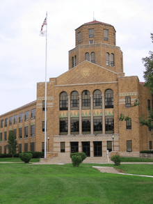

Park Ridge is served by the Park Ridge-Niles School District 64, which has its headquarters in the Raymond E. Hendee Educational Service Center in Park Ridge.[14] Area middle schools include Lincoln Middle School and Emerson Middle School in Niles. At one point there were nine public K–6 elementary schools: Oakton, Madison, Edison, Merrill, Carpenter, Field, Franklin, Roosevelt, and Washington. Only the latter five remain today, and all are in Park Ridge. Jefferson School is also part of the district and houses the special needs preschool for children ages 3 and 4, the extended day kindergarten program, and the after school program for grades K–6.[15]
St. Paul of the Cross and Mary Seat of Wisdom are the two Catholic elementary schools.[16] St. Andrews is a Lutheran elementary school.
The town is served by Maine Township High School District 207, which includes Maine South High School, and Maine East High School. Students who live in northern Park Ridge have the option of attending either Maine East or Maine South. Maine West High School is located to the west in Des Plaines. Maine North High School was a school in unincorporated Maine Township and part of Maine Township High School District 207. It closed in 1981 as the student population of Maine Township shrank.
District 207 shares student-run radio and television stations operating with the call letters WMTH-FM (W Maine Township High). Actor Harrison Ford, known for his roles in the Indiana Jones, Star Wars, and Blade Runner movies, went to Maine East, and has been credited as being the radio station's first sports announcer. Since 2007, WMTH Radio can be heard live on any of the district high school homepage.
The town is a part of the Oakton Community College district.
Athletics
Park Ridge is home to the Park Ridge Falcons, the 2002 Pop Warner Football Tomlin Division Pee Wee National Champions.
Park Ridge is home to three American Youth Football National Champions (2006, 2007, 2009) and one American Youth Cheerleading National Champion (2007).
The Maine South Hawks football team were State Champions in 1995, 2000, 2008, 2009, 2010 and 2016, and Runners-Up in 2003, 2004, and 2005.
Economy
Top employers
According to Park Ridge's 2018 Comprehensive Annual Financial Report,[17] the top employers in the city were:
| # | Employer | # of Employees |
|---|---|---|
| 1 | Advocate Lutheran General Hospital | 4,200[18] |
| 2 | Maine Township High School District 207 | 908 |
| 3 | Park Ridge Park District | 813 |
| 4 | Park Ridge-Niles School District 64 | 722 |
| 5 | City of Park Ridge | 453 |
| 6 | Presence Resurrection Health Care | 300 |
| 7 | Mariano's Fresh Market | 276 |
| 8 | Nesset Healthcare (Advocate) | 221 |
| 9 | Park Ridge Community Bank | 220 |
| 10 | Avantara Park Ridge | 200 |
Notable people
Park Ridge is the hometown of Hillary Rodham Clinton. When she visited Park Ridge on the occasion of her 50th birthday in 1997, the city renamed the southeast corner of the intersection of Elm and Wisner streets, next to her childhood home, "Rodham Corner". Clinton graduated from Maine Township High School South, a new school built to accommodate the population of baby boomers coming through at the time.[19]
Park Ridge is also the hometown of movie stars Carrie Snodgress, Karen Black, and Harrison Ford. All four attended Maine Township High School East. Sean Giambrone also grew up in Park Ridge. He is most notable for his role in The Goldbergs as Adam. He went to Lincoln Middle School and Maine South High School.
The first U.S. citizen to be canonized, Mother Frances Cabrini, attended St. Paul of the Cross Church and owned a farm at the north edge of Park Ridge.[20]
Culture
Landmarks
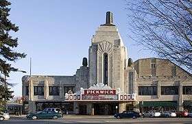

- Park Ridge's most recognizable landmark is the Pickwick Theatre, an Art Deco building dating back to 1928. It is a movie theater and a venue for plays and concerts. In 1975, the theater was named to the National Register of Historic Places. Although smaller theaters have been added to the rear of the building, the main auditorium theater remains intact in its original large five-aisle state. The main auditorium can seat up to 1,400 people. In the 1980s, the Pickwick's facade was one of many used as the backdrop for the opening credits of Gene Siskel and Roger Ebert's At the Movies.
- Park Ridge Public Library.
References in popular culture
In film
- The 1980 film The Blues Brothers had some scenes filmed in Park Ridge. The scenes where the brothers were first pulled over by the state police and the beginning of the subsequent chase were filmed there. The Nelson Funeral Home and Shell gas station which the brothers drove past as the police pulled out to intercept them are still in business at the intersection of Talcott and Cumberland avenues. The brothers were pulled over at the intersection of Cumberland and Gillick. As the chase progressed, a trooper radioed that the chase was "proceeding on Courtland Avenue". The scene where the Blues Brothers and the police spun out in a three-way intersection occurred at the intersection of Devon Avenue, Talcott Road, and Courtland Avenue.[22][23][24][25]
- In the 1990 film Home Alone, Buzz McCallister wears a Maine South High School letterman's jacket.
External links
- City of Park Ridge official website
- Park Ridge Public Library
- Park Ridge Community Network, from Park Ridge Public Library
- A history of Park Ridge, Illinois
References
- "2016 U.S. Gazetteer Files". United States Census Bureau. Retrieved June 30, 2017.
- "Profile of General Population and Housing Characteristics: 2010 Demographic Profile Data (DP-1): Park Ridge city, Illinois". U.S. Census Bureau, American Factfinder. Archived from the original on February 12, 2020. Retrieved February 13, 2013.
- "Population and Housing Unit Estimates". Retrieved May 21, 2020.
- "The History of Park Ridge". City of Park Ridge.
- "Gazetteer Files - Geography - U.S. Census Bureau". Census.gov. Retrieved April 16, 2014.
- Encyclopedia of Chicago, Park Ridge
- Milton E. Nelson, Park Ridge: Milestones Of History pp. 156, 159 (2017)
- "G001 - Geographic Identifiers - 2010 Census Summary File 1". United States Census Bureau. Archived from the original on February 13, 2020. Retrieved December 27, 2015.
- "USDA Plant Hardiness Zone Map". Agricultural Research Center, PRISM Climate Group Oregon State University. USDA. Archived from the original on February 27, 2014. Retrieved February 24, 2014.
- "Census of Population and Housing". Census.gov. Retrieved June 4, 2015.
- "2010 United States Census Data". census.gov. Archived from the original on June 26, 2012. Retrieved July 20, 2012.
- "U.S. Census website". United States Census Bureau. Retrieved January 31, 2008.
- "2006-2008 American Community Survey for Park Ridge, Illinois". U.S. Census Bureau. Archived from the original on February 10, 2020. Retrieved July 14, 2010.
- "banner_dist.jpg Archived 2013-02-21 at the Wayback Machine." Park Ridge-Niles School District. Retrieved on January 10, 2012. "164 South Prospect Avenue Park Ridge, IL 60068"
- Park Ridge - Niles Phone: 847.318.4300. "Park Ridge - Niles | PowerIT". D64.org. Retrieved April 16, 2014.
- "Welcome to MSW, A Blue Ribbon School of Excellence".
- "City of Park Ridge CAFR" (PDF). parkridge.us.
- "About Us".
- "Hillary Rodham Clinton: Her Park Ridge Connection," Park Ridge Public Library, 2016. Retrieved 13 Aug. 2019.
- Milton E. Nelson, Park Ridge: Milestones of History p. 95 (2017)
- "Archived copy". Archived from the original on August 11, 2017. Retrieved April 4, 2017.CS1 maint: archived copy as title (link)
- "Blues Brothers location guide" Archived 2008-08-24 at the Wayback Machine, Movie-locations.com, Retrieved August 12, 2008
- "Filming locations for The Blues Brothers", IMDb
- Reardon, Patrick T. (January 29, 2008), "Lost Chicago Found on Film", p. 2, Chicago Tribune, Retrieved August 12, 2008
- The Blues Brothers: 25th Anniversary Edition, 2005, scene 4
| Major city | 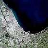 | |
|---|---|---|
| Cities (over 30,000 in 2010) | ||
| Towns and villages (over 30,000 in 2010) |
| |
| Counties | ||
| Regions |
| |
| Sub-regions | ||
Places adjacent to Park Ridge, Illinois | |
|---|---|
| Authority control |
|
|---|