Morgan County, Illinois
Morgan County is a county located in the U.S. state of Illinois. According to the 2010 census, it had a population of 35,547.[1] Its county seat is Jacksonville.[2]
Morgan County | |
|---|---|
 Morgan County Courthouse, Jacksonville | |
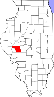 Location within the U.S. state of Illinois | |
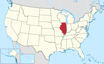 Illinois's location within the U.S. | |
| Coordinates: 39°43′N 90°12′W | |
| Country | |
| State | |
| Founded | 1823 |
| Named for | Daniel Morgan |
| Seat | Jacksonville |
| Largest city | Jacksonville |
| Area | |
| • Total | 572 sq mi (1,480 km2) |
| • Land | 569 sq mi (1,470 km2) |
| • Water | 3.5 sq mi (9 km2) 0.6% |
| Population (2010) | |
| • Total | 35,547 |
| • Estimate (2018) | 33,976 |
| • Density | 62/sq mi (24/km2) |
| Time zone | UTC−6 (Central) |
| • Summer (DST) | UTC−5 (CDT) |
| Congressional district | 18th |
Morgan County is part of the Jacksonville, IL Micropolitan Statistical Area, which is also included in the Springfield-Jacksonville-Lincoln, IL Combined Statistical Area.
History
Morgan County was formed in 1823 out of Greene and Sangamon Counties. It was named in honor of General Daniel Morgan, who defeated the British at the Battle of Cowpens in the American Revolutionary War. General Morgan was serving under General Nathanael Greene at Cowpens. Jacksonville was established by European Americans on a 160-acre tract of land in the center of Morgan County in 1825, two years after the county was founded. The founders of Jacksonville, Illinois consisted entirely of settlers from New England. These people were "Yankee" settlers, that is to say they were descended from the English Puritans who settled New England in the 1600s. They were part of a wave of New England farmers who headed west into what was then the wilds of the Northwest Territory during the early 1800s. Most of them arrived as a result of the completion of the Erie Canal and the end of the Black Hawk War. The Yankee migration to Illinois was a result of several factors, one of which was the overpopulation of New England. The old stock Yankee population had large families, often bearing up to ten children in one household. Most people were expected to have their own piece of land to farm, and due to the massive and nonstop population boom, land in New England became scarce as every son claimed his own farmstead. As a result, there was not enough land for every family to have a self-sustaining farm, and Yankee settlers began leaving New England for the Midwestern United States. When they arrived in what is now Jacksonville there was nothing but dense virgin forest and wild prairie, the "Yankee" New Englanders laid out farms, constructed roads, erected government buildings and established post routes. They brought with them many of their Yankee New England values, such as a passion for education, establishing many schools as well as staunch support for abolitionism. They were mostly members of the Congregationalist Church though some were Episcopalian. Due to the second Great Awakening some of them had converted to Methodism and Presbyterianism while some others became Baptist, before moving to what is now Jacksonville. Jacksonville, like some other parts of Illinois, would be culturally very continuous with early New England culture for most of its early history.[3][4][5][6][7][8][9]
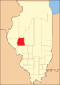 Morgan County from the time of its creation to 1837
 Morgan County between 1837 and 1839, when Scott County was split off
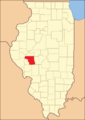 Morgan County between 1839 and 1845
 Morgan County in 1845, when its border with Cass County was moved southward, bringing both to their present borders
Geography
According to the US Census Bureau, the county has a total area of 572 square miles (1,480 km2), of which 569 square miles (1,470 km2) is land and 3.5 square miles (9.1 km2) (0.6%) is water.[10]
Climate and weather
| Jacksonville, Illinois | ||||||||||||||||||||||||||||||||||||||||||||||||||||||||||||
|---|---|---|---|---|---|---|---|---|---|---|---|---|---|---|---|---|---|---|---|---|---|---|---|---|---|---|---|---|---|---|---|---|---|---|---|---|---|---|---|---|---|---|---|---|---|---|---|---|---|---|---|---|---|---|---|---|---|---|---|---|
| Climate chart (explanation) | ||||||||||||||||||||||||||||||||||||||||||||||||||||||||||||
| ||||||||||||||||||||||||||||||||||||||||||||||||||||||||||||
| ||||||||||||||||||||||||||||||||||||||||||||||||||||||||||||
Average temperatures in the county seat of Jacksonville range from a low of 15 °F (−9 °C) in January to a high of 87 °F (31 °C) in July; a record low of −28 °F (−33 °C) was recorded in February 1934 and a record high of 114 °F (46 °C) was recorded in July 1954. Average monthly precipitation ranged from 1.35 inches (34 mm) in January to 4.86 inches (123 mm) in May.[11]
Major highways
Adjacent counties
- Cass County - north
- Sangamon County - east
- Macoupin County - southeast
- Greene County - south
- Pike County - west
- Scott County - west
- Brown County - northwest
National protected area
Demographics
| Historical population | |||
|---|---|---|---|
| Census | Pop. | %± | |
| 1830 | 12,714 | — | |
| 1840 | 19,547 | 53.7% | |
| 1850 | 16,064 | −17.8% | |
| 1860 | 22,112 | 37.6% | |
| 1870 | 28,463 | 28.7% | |
| 1880 | 31,514 | 10.7% | |
| 1890 | 32,636 | 3.6% | |
| 1900 | 35,006 | 7.3% | |
| 1910 | 34,420 | −1.7% | |
| 1920 | 33,567 | −2.5% | |
| 1930 | 34,240 | 2.0% | |
| 1940 | 36,378 | 6.2% | |
| 1950 | 35,568 | −2.2% | |
| 1960 | 36,571 | 2.8% | |
| 1970 | 36,174 | −1.1% | |
| 1980 | 37,502 | 3.7% | |
| 1990 | 36,397 | −2.9% | |
| 2000 | 36,616 | 0.6% | |
| 2010 | 35,547 | −2.9% | |
| Est. 2018 | 33,976 | [12] | −4.4% |
| US Decennial Census[13] 1790-1960[14] 1900-1990[15] 1990-2000[16] 2010-2013[1] | |||
As of the 2010 United States Census, there were 35,547 people, 14,104 households, and 8,851 families residing in the county.[17] The population density was 62.5 inhabitants per square mile (24.1/km2). There were 15,515 housing units at an average density of 27.3 per square mile (10.5/km2).[10] The racial makeup of the county was 90.9% white, 6.0% black or African American, 0.5% Asian, 0.2% American Indian, 0.8% from other races, and 1.6% from two or more races. Those of Hispanic or Latino origin made up 2.0% of the population.[17] In terms of ancestry, 25.9% were German, 21.6% were American, 15.4% were Irish, and 14.5% were English.[18] Those citing "American" ancestry in Morgan County, Illinois are of overwhelmingly English extraction, in many cases going back to colonial New England, however most English Americans identify simply as having "American" ancestry because their roots have been in North America for so long, in many cases since the early sixteen hundreds.[19][20][21][22]
Of the 14,104 households, 28.3% had children under the age of 18 living with them, 47.4% were married couples living together, 11.2% had a female householder with no husband present, 37.2% were non-families, and 31.5% of all households were made up of individuals. The average household size was 2.30 and the average family size was 2.86. The median age was 40.8 years.[17]
The median income for a household in the county was $44,645 and the median income for a family was $59,185. Males had a median income of $43,609 versus $29,893 for females. The per capita income for the county was $23,244. About 11.2% of families and 16.4% of the population were below the poverty line, including 25.8% of those under age 18 and 7.5% of those age 65 or over.[23]
Communities
Cities
Politics
Morgan County has been reliably Republican from its beginning; the Democratic nominee has gained a plurality only 19% of the time (6 of 32 elections).
| Year | Republican | Democratic | Third parties |
|---|---|---|---|
| 2016 | 61.3% 9,076 | 31.7% 4,696 | 7.0% 1,028 |
| 2012 | 56.4% 7,972 | 41.1% 5,806 | 2.6% 364 |
| 2008 | 49.3% 7,591 | 48.5% 7,467 | 2.2% 336 |
| 2004 | 61.9% 9,392 | 37.2% 5,650 | 0.9% 138 |
| 2000 | 56.2% 8,058 | 41.2% 5,899 | 2.6% 377 |
| 1996 | 44.6% 6,352 | 43.2% 6,150 | 12.2% 1,736 |
| 1992 | 40.3% 6,566 | 39.0% 6,351 | 20.7% 3,380 |
| 1988 | 59.2% 8,808 | 40.5% 6,032 | 0.3% 46 |
| 1984 | 66.4% 10,683 | 33.3% 5,361 | 0.3% 53 |
| 1980 | 61.2% 10,406 | 32.3% 5,483 | 6.5% 1,108 |
| 1976 | 53.9% 8,885 | 44.9% 7,403 | 1.2% 201 |
| 1972 | 66.1% 11,103 | 33.8% 5,674 | 0.1% 12 |
| 1968 | 54.5% 8,902 | 38.5% 6,281 | 7.0% 1,144 |
| 1964 | 44.0% 7,240 | 56.1% 9,235 | 0.0% 0 |
| 1960 | 57.4% 9,791 | 42.5% 7,259 | 0.1% 12 |
| 1956 | 61.8% 10,262 | 38.1% 6,327 | 0.1% 11 |
| 1952 | 61.0% 10,405 | 38.9% 6,637 | 0.0% 4 |
| 1948 | 55.1% 8,398 | 44.6% 6,798 | 0.4% 59 |
| 1944 | 56.0% 8,923 | 43.7% 6,965 | 0.3% 42 |
| 1940 | 52.6% 10,137 | 47.1% 9,082 | 0.3% 64 |
| 1936 | 47.0% 8,844 | 52.1% 9,800 | 0.9% 167 |
| 1932 | 43.0% 7,787 | 56.1% 10,170 | 1.0% 173 |
| 1928 | 63.5% 10,192 | 36.2% 5,805 | 0.3% 49 |
| 1924 | 55.4% 8,223 | 38.5% 5,721 | 6.1% 900 |
| 1920 | 62.9% 8,169 | 34.2% 4,447 | 2.9% 377 |
| 1916 | 50.3% 7,536 | 47.4% 7,104 | 2.4% 358 |
| 1912 | 27.6% 2,090 | 48.1% 3,648 | 24.3% 1,844 |
| 1908 | 48.1% 4,019 | 47.8% 3,993 | 4.2% 351 |
| 1904 | 51.7% 4,248 | 40.6% 3,343 | 7.7% 634 |
| 1900 | 48.7% 4,341 | 48.4% 4,321 | 2.9% 260 |
| 1896 | 49.3% 4,317 | 49.3% 4,323 | 1.4% 121 |
| 1892 | 43.7% 3,471 | 50.4% 4,006 | 5.9% 470 |
References
- "State & County QuickFacts". US Census Bureau. Archived from the original on June 7, 2011. Retrieved July 7, 2014.
- "Find a County". National Association of Counties. Retrieved June 7, 2011.
- The Yankee Exodus: An Account of Migration from New England by Stewart Hall Holbrook University of Washington Press, 1968
- American Zion: The Old Testament as a Political Text from the Revolution to ... By Eran Shalev, Yale University Press, Mar 26, 2013 ISBN 9780300186925page 70-71
- Recollections of a Nonagenarian of Life in New England, the Middle West, and ... By John Calvin Holbrook pg. 96
- Jacksonville, Illinois: The Traditions Continue By Betty Carlson Kay, Gary Jack Barwick pg. 21
- Yankee Colonies across America: Cities upon the Hills By Chaim M. Rosenberg pg. 81
- New England in the Life of the World: A Record of Adventure and Achievement By Howard Allen Bridgman pg. 93
- Bridgman, Howard Allen (1920). New England in the Life of the World: A Record of Adventure and Achievement. Pilgrim Press.
- "Population, Housing Units, Area, and Density: 2010 - County". US Census Bureau. Archived from the original on February 13, 2020. Retrieved July 12, 2015.
- "Monthly Averages for Jacksonville, Illinois". The Weather Channel. Retrieved January 27, 2011.
- "Population and Housing Unit Estimates". Retrieved November 3, 2019.
- "US Decennial Census". US Census Bureau. Retrieved July 7, 2014.
- "Historical Census Browser". University of Virginia Library. Retrieved July 7, 2014.
- "Population of Counties by Decennial Census: 1900 to 1990". US Census Bureau. Retrieved July 7, 2014.
- "Census 2000 PHC-T-4. Ranking Tables for Counties: 1990 and 2000" (PDF). US Census Bureau. Retrieved July 7, 2014.
- "Profile of General Population and Housing Characteristics: 2010 Demographic Profile Data". US Census Bureau. Archived from the original on February 13, 2020. Retrieved July 12, 2015.
- "Selected Social Characteristics in the United States – 2006-2010 American Community Survey 5-Year Estimates". US Census Bureau. Archived from the original on February 13, 2020. Retrieved July 12, 2015.
- Pulera, Dominic (October 20, 2004). Sharing the Dream: White Males in Multicultural America. A&C Black. p. 57. ISBN 978-0-8264-1643-8.
- Reynolds Farley, 'The New Census Question about Ancestry: What Did It Tell Us?', Demography, Vol. 28, No. 3 (August 1991), pp. 414, 421.
- Stanley Lieberson and Lawrence Santi, 'The Use of Nativity Data to Estimate Ethnic Characteristics and Patterns', Social Science Research, Vol. 14, No. 1 (1985), pp. 44–46.
- Stanley Lieberson and Mary C. Waters, 'Ethnic Groups in Flux: The Changing Ethnic Responses of American Whites', Annals of the American Academy of Political and Social Science, Vol. 487, No. 79 (September 1986), pp. 82–86.
- "Selected Economic Characteristics – 2006-2010 American Community Survey 5-Year Estimates". US Census Bureau. Archived from the original on February 13, 2020. Retrieved July 12, 2015.
- Leip, David. "Dave Leip's Atlas of U.S. Presidential Elections". uselectionatlas.org. Retrieved March 31, 2018.
External links
Places adjacent to Morgan County, Illinois | ||||||||||
|---|---|---|---|---|---|---|---|---|---|---|
| ||||||||||
Municipalities and communities of Morgan County, Illinois, United States | ||
|---|---|---|
| Cities | Map of Illinois highlighting Morgan County | |
| Villages | ||
| Unincorporated communities | ||