Jasper County, Illinois
Jasper County is a county located in the U.S. state of Illinois. According to the 2010 census, it has a population of 9,698.[1] Its county seat is Newton.[2]
Jasper County | |
|---|---|
 Jasper County Courthouse in Newton | |
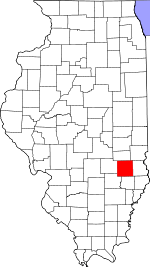 Location within the U.S. state of Illinois | |
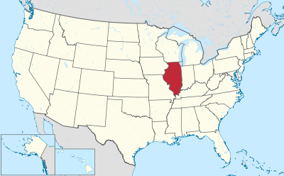 Illinois's location within the U.S. | |
| Coordinates: 39°01′N 88°09′W | |
| Country | |
| State | |
| Founded | 1831 |
| Named for | William Jasper |
| Seat | Newton |
| Largest city | Newton |
| Area | |
| • Total | 498 sq mi (1,290 km2) |
| • Land | 495 sq mi (1,280 km2) |
| • Water | 3.6 sq mi (9 km2) 0.7% |
| Population (2010) | |
| • Total | 9,698 |
| • Estimate (2018) | 9,611 |
| • Density | 19/sq mi (7.5/km2) |
| Time zone | UTC−6 (Central) |
| • Summer (DST) | UTC−5 (CDT) |
| Congressional district | 15th |
History
Jasper County was formed in 1831 out of Clay and Crawford Counties. It was named for Sgt. William Jasper, a Revolutionary War hero from South Carolina. During the defense of Fort Moultrie in 1776, the staff of the American flag was shot away. Sgt. Jasper attached the flag to a pole and stood on the wall waving the flag at the British until a new staff was erected.
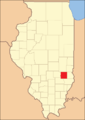 Jasper County at the time of its creation in 1831
Geography
According to the U.S. Census Bureau, the county has a total area of 498 square miles (1,290 km2), of which 495 square miles (1,280 km2) is land and 3.6 square miles (9.3 km2) (0.7%) is water.[3]
Climate and weather
| Newton, Illinois | ||||||||||||||||||||||||||||||||||||||||||||||||||||||||||||
|---|---|---|---|---|---|---|---|---|---|---|---|---|---|---|---|---|---|---|---|---|---|---|---|---|---|---|---|---|---|---|---|---|---|---|---|---|---|---|---|---|---|---|---|---|---|---|---|---|---|---|---|---|---|---|---|---|---|---|---|---|
| Climate chart (explanation) | ||||||||||||||||||||||||||||||||||||||||||||||||||||||||||||
| ||||||||||||||||||||||||||||||||||||||||||||||||||||||||||||
| ||||||||||||||||||||||||||||||||||||||||||||||||||||||||||||
In recent years, average temperatures in the county seat of Newton have ranged from a low of 18 °F (−8 °C) in January to a high of 85 °F (29 °C) in July, although a record low of −28 °F (−33 °C) was recorded in January 1994 and a record high of 112 °F (44 °C) was recorded in July 1954. Average monthly precipitation ranged from 2.38 inches (60 mm) in January to 4.39 inches (112 mm) in May.[4]
Adjacent counties
- Cumberland County – north
- Clark County – northeast
- Crawford County – east
- Richland County – south
- Clay County – southwest
- Effingham County – west
Demographics
| Historical population | |||
|---|---|---|---|
| Census | Pop. | %± | |
| 1840 | 1,472 | — | |
| 1850 | 3,220 | 118.8% | |
| 1860 | 8,364 | 159.8% | |
| 1870 | 11,234 | 34.3% | |
| 1880 | 14,515 | 29.2% | |
| 1890 | 18,188 | 25.3% | |
| 1900 | 20,160 | 10.8% | |
| 1910 | 18,157 | −9.9% | |
| 1920 | 16,064 | −11.5% | |
| 1930 | 12,809 | −20.3% | |
| 1940 | 13,431 | 4.9% | |
| 1950 | 12,266 | −8.7% | |
| 1960 | 11,346 | −7.5% | |
| 1970 | 10,741 | −5.3% | |
| 1980 | 11,318 | 5.4% | |
| 1990 | 10,609 | −6.3% | |
| 2000 | 10,117 | −4.6% | |
| 2010 | 9,698 | −4.1% | |
| Est. 2018 | 9,611 | [5] | −0.9% |
| U.S. Decennial Census[6] 1790–1960[7] 1900–1990[8] 1990–2000[9] 2010–2013[1] | |||

As of the 2010 United States Census, there were 9,698 people, 3,940 households, and 2,800 families living in the county.[10] The population density was 19.6 inhabitants per square mile (7.6/km2). There were 4,345 housing units at an average density of 8.8 per square mile (3.4/km2).[3] The racial makeup of the county was 98.6% white, 0.2% Asian, 0.1% American Indian, 0.1% black or African American, 0.3% from other races, and 0.6% from two or more races. Those of Hispanic or Latino origin made up 0.8% of the population.[10] In terms of ancestry, 39.5% were German, 12.5% were American, 11.0% were Irish, and 9.1% were English.[11]
Of the 3,940 households, 29.7% had children under the age of 18 living with them, 59.1% were married couples living together, 7.9% had a female householder with no husband present, 28.9% were non-families, and 24.5% of all households were made up of individuals. The average household size was 2.45 and the average family size was 2.90. The median age was 42.7 years.[10]
The median income for a household in the county was $46,546 and the median income for a family was $53,034. Males had a median income of $39,167 versus $24,856 for females. The per capita income for the county was $21,467. About 6.3% of families and 8.5% of the population were below the poverty line, including 10.6% of those under age 18 and 5.1% of those aged 65 or over.[12]
Education
Jasper County is largely served by Jasper County Community Unit School District 1, which is based in its county seat, Newton. Five of the district's six schools are located in Jasper County. Saint Thomas Catholic School is a private elementary school, also in Newton.
Communities
City
Villages
Unincorporated communities
- Bogota
- Hunt City
- West Liberty
- Lis
- Boos
- Falmouth
- Gila
- Latona
- Raeftown
- Island Grove
- Advance
- Point Pleasant
Townships
Jasper County is divided into eleven townships:
Notable residents
- Glenn Brummer, baseball catcher for the Major League Baseball St. Louis Cardinals and Texas Rangers; member of the 1982 World Champion Cardinals
- Irene Hunt, author of the classic Across Five Aprils
- Albert Isley, Illinois judge, lawyer, and state senator
- Burl Ives, folk singer, author, and actor
- Ross Wolf, baseball pitcher; plays for the SK Wyverns of the Korea Baseball Championship; formerly played for several Major League Baseball teams
Politics
Jasper is politically a fairly typical "anti-Yankee" Southern Illinois county. Opposition to the "Yankee" Republican Party and that party's Civil War meant that Jasper County voted solidly Democratic until isolationist sentiment drove its voters to Warren G. Harding in 1920.
Since the New Deal, the county has shown a steady trend away from the Democratic Party due to major shifts in that party's views – initially on economic policies, and since the 1990s on social issues.[13] Only one Democrat – Lyndon Johnson in his 1964 landslide – has won a majority since 1940, and as is typical of the Upland South, Barack Obama in 2012 and Hillary Clinton did far worse than any previous Democrat.
| Year | Republican | Democratic | Third parties |
|---|---|---|---|
| 2016 | 77.8% 3,975 | 18.1% 924 | 4.2% 213 |
| 2012 | 69.7% 3,514 | 28.5% 1,436 | 1.8% 93 |
| 2008 | 57.6% 2,964 | 40.1% 2,063 | 2.2% 115 |
| 2004 | 66.1% 3,529 | 33.4% 1,781 | 0.5% 26 |
| 2000 | 62.1% 3,119 | 36.2% 1,815 | 1.7% 87 |
| 1996 | 45.1% 2,234 | 41.2% 2,038 | 13.7% 679 |
| 1992 | 36.4% 1,996 | 41.7% 2,284 | 21.9% 1,200 |
| 1988 | 58.3% 3,024 | 41.1% 2,135 | 0.6% 30 |
| 1984 | 67.4% 3,673 | 32.1% 1,750 | 0.6% 31 |
| 1980 | 63.2% 3,548 | 32.9% 1,846 | 3.9% 218 |
| 1976 | 49.5% 2,794 | 49.1% 2,772 | 1.5% 84 |
| 1972 | 61.2% 3,461 | 37.4% 2,114 | 1.5% 82 |
| 1968 | 51.8% 2,944 | 35.4% 2,012 | 12.8% 730 |
| 1964 | 43.4% 2,614 | 56.6% 3,406 | |
| 1960 | 52.8% 3,393 | 47.1% 3,027 | 0.0% 1 |
| 1956 | 51.8% 3,107 | 48.2% 2,895 | |
| 1952 | 57.8% 3,753 | 42.0% 2,728 | 0.2% 10 |
| 1948 | 49.8% 2,957 | 49.4% 2,936 | 0.8% 50 |
| 1944 | 52.1% 3,453 | 47.4% 3,142 | 0.4% 29 |
| 1940 | 52.2% 4,082 | 47.2% 3,689 | 0.6% 44 |
| 1936 | 42.9% 3,221 | 55.3% 4,149 | 1.8% 132 |
| 1932 | 34.2% 2,300 | 65.3% 4,390 | 0.5% 36 |
| 1928 | 51.0% 3,201 | 48.7% 3,055 | 0.3% 16 |
| 1924 | 47.4% 3,030 | 49.2% 3,144 | 3.5% 223 |
| 1920 | 51.6% 3,279 | 46.8% 2,971 | 1.6% 101 |
| 1916 | 43.4% 3,110 | 54.2% 3,884 | 2.5% 179 |
| 1912 | 31.1% 1,227 | 51.8% 2,042 | 17.1% 675 |
| 1908 | 43.0% 1,860 | 53.6% 2,317 | 3.4% 148 |
| 1904 | 45.2% 1,889 | 48.4% 2,024 | 6.4% 266 |
| 1900 | 41.6% 1,923 | 56.0% 2,591 | 2.4% 112 |
| 1896 | 40.1% 1,867 | 58.5% 2,724 | 1.3% 62 |
| 1892 | 36.7% 1,519 | 53.6% 2,217 | 9.7% 399 |
References
- "State & County QuickFacts". United States Census Bureau. Archived from the original on June 6, 2011. Retrieved July 6, 2014.
- "Find a County". National Association of Counties. Archived from the original on May 31, 2011. Retrieved June 7, 2011.
- "Population, Housing Units, Area, and Density: 2010 – County". United States Census Bureau. Archived from the original on February 12, 2020. Retrieved July 11, 2015.
- "Monthly Averages for Newton, Illinois". The Weather Channel. Retrieved January 27, 2011.
- "Population and Housing Unit Estimates". Retrieved November 6, 2019.
- "U.S. Decennial Census". United States Census Bureau. Retrieved July 6, 2014.
- "Historical Census Browser". University of Virginia Library. Retrieved July 6, 2014.
- "Population of Counties by Decennial Census: 1900 to 1990". United States Census Bureau. Retrieved July 6, 2014.
- "Census 2000 PHC-T-4. Ranking Tables for Counties: 1990 and 2000" (PDF). United States Census Bureau. Retrieved July 6, 2014.
- "DP-1 Profile of General Population and Housing Characteristics: 2010 Demographic Profile Data". United States Census Bureau. Archived from the original on February 13, 2020. Retrieved July 11, 2015.
- "DP02 SELECTED SOCIAL CHARACTERISTICS IN THE UNITED STATES – 2006–2010 American Community Survey 5-Year Estimates". United States Census Bureau. Archived from the original on February 13, 2020. Retrieved July 11, 2015.
- "DP03 SELECTED ECONOMIC CHARACTERISTICS – 2006–2010 American Community Survey 5-Year Estimates". United States Census Bureau. Archived from the original on February 13, 2020. Retrieved July 11, 2015.
- Cohn, Nate; ‘Demographic Shift: Southern Whites’ Loyalty to G.O.P. Nearing That of Blacks to Democrats’, New York Times, April 24, 2014
- Leip, David. "Dave Leip's Atlas of U.S. Presidential Elections". uselectionatlas.org. Retrieved March 31, 2018.
External links
Places adjacent to Jasper County, Illinois | ||||||||||
|---|---|---|---|---|---|---|---|---|---|---|
| ||||||||||
Municipalities and communities of Jasper County, Illinois, United States | ||
|---|---|---|
| Cities | Map of Illinois highlighting Jasper County | |
| Villages | ||
| Townships | ||
| Unincorporated communities | ||

| Authority control |
|
|---|